Sixteen Mile Creek (Niagara Region)
Sixteen Mile Creek is a stream in the municipalities of Lincoln, Pelham and West Lincoln, Regional Municipality of Niagara in Southern Ontario, Canada.[1] It is part of the Great Lakes Basin and flows from the top of the Niagara Escarpment to Sixteen Mile Pond on Lake Ontario. The stream falls within the remit of the Niagara Peninsula Conservation Authority,[2] whose 2012 watershed report card gave the stream watershed grades of D for both water quality and forest cover.[2]
| Sixteen Mile Creek | |
|---|---|
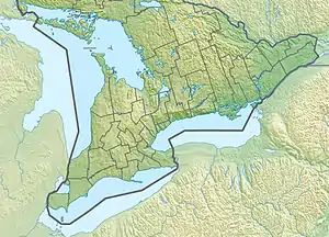 Location of the mouth of Sixteen Mile Creek in southern Ontario | |
| Location | |
| Country | Canada |
| Province | Ontario |
| Region | Southern Ontario |
| Regional Municipality | Niagara |
| Municipalities | |
| Physical characteristics | |
| Source | Field |
| • location | West Lincoln |
| • coordinates | 43°03′41″N 79°31′26″W |
| • elevation | 182 m (597 ft) |
| Mouth | Sixteen Mile Creek Pond at Lake Ontario |
• location | Lincoln |
• coordinates | 43°09′34″N 79°20′02″W |
• elevation | 74 m (243 ft) |
| Basin features | |
| River system | Great Lakes Basin |
References
- "Sixteen Mile Creek". Geographical Names Data Base. Natural Resources Canada. Retrieved 2014-04-18.
- "Lake Ontario South Shore" (PDF). 2012 Watershed Report Card. Niagara Peninsula Conservation Authority. 2013. Retrieved 2014-04-18.
Sources
- Map 3 (PDF) (Map). 1 : 700,000. Official road map of Ontario. Ministry of Transportation of Ontario. 2010-01-01. Retrieved 2014-04-18.
- Restructured municipalities - Ontario map #6 (Map). Restructuring Maps of Ontario. Ontario Ministry of Municipal Affairs and Housing. 2006. Retrieved 2014-04-18.
- "Drainage basins and subwatersheds" (PDF). 2012 Watershed Report Card. Niagara Peninsula Conservation Authority. 2013. Archived from the original (PDF) on 2014-04-16. Retrieved 2014-04-18.
Great Lakes of North America | ||
|---|---|---|
| Main lakes |  | |
| Secondary lakes | ||
| Bays and Waterways |
| |
| Islands | ||
| Historic geology | ||
| Government | ||
| Related topics | ||
This article is issued from Wikipedia. The text is licensed under Creative Commons - Attribution - Sharealike. Additional terms may apply for the media files.