Soo Locks
The Soo Locks (sometimes spelled Sault Locks, but pronounced "soo") are a set of parallel locks, operated and maintained by the United States Army Corps of Engineers, Detroit District, that enable ships to travel between Lake Superior and the lower Great Lakes. They are located on the St. Marys River between Lake Superior and Lake Huron, between the Upper Peninsula of the U.S. state of Michigan and the Canadian province of Ontario. They bypass the rapids of the river, where the water falls 21 feet (6.4 m). The locks pass an average of 10,000 ships per year,[4] despite being closed during the winter from January through March, when ice shuts down shipping on the Great Lakes. The winter closure period is used to inspect and maintain the locks.
St. Marys Falls Canal | |
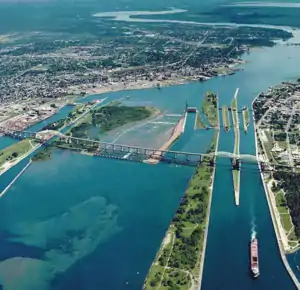 Aerial view of the Soo Locks. View is to the east, with Canada on the left and the United States on the right | |
  | |
| Location | Sault Ste. Marie, Michigan |
|---|---|
| Coordinates | 46°30′02″N 84°21′40″W |
| Built | 1855 |
| Architect | Corps of Engineers |
| NRHP reference No. | 66000394[1] |
| Significant dates | |
| Added to NRHP | November 13, 1966 |
| Designated NHL | November 13, 1966[2] |
| Designated MSHS | February 12, 1959[3] |
The locks share a name (usually shortened and anglicized as Soo) with the two cities named Sault Ste. Marie, in Ontario and in Michigan, located on either side of the St. Marys River. The Sault Ste. Marie International Bridge between the United States and Canada permits vehicular traffic to pass over the locks. A railroad bridge crosses the St. Marys River just upstream of the highway bridge.
The first locks were opened in 1855. Along with the Erie Canal, constructed in 1824 in central New York State, they were one of the great infrastructure engineering projects of the antebellum United States. The Soo Locks were designated a National Historic Landmark in 1966.[5]
During World War II, the Soo Locks and the St. Marys River waterway were heavily guarded by U.S. and Canadian forces coordinated by the U.S. Army's Central Defense Command. A one-way German air attack on the locks by forces based in Norway was thought to be possible.[6]
United States locks
The U.S. locks form part of a 1.6-mile (2.6 km) canal formally named the St. Marys Falls Canal. The entire canal, including the locks, is owned and maintained by the United States Army Corps of Engineers, which provides free passage. The first iteration of the U.S. Soo Locks was completed in May 1855; it was operated by the State of Michigan until transferred to the U.S. Army in 1881. The first federal lock, the Weitzel Lock, was built in 1881 and replaced by the MacArthur Lock in 1943.[7][8]
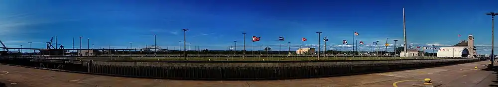
The current configuration consists of four parallel lock chambers, each running east to west. Starting at the Michigan shoreline and moving north toward Ontario, these are:
- The MacArthur Lock, built in 1943. It is 800 feet (240 m) long, 80 feet (24 m) wide, and 29.5 feet (9.0 m) deep.[9] This is large enough to handle ocean-going vessels ("salties") that must also pass through the smaller locks in the Welland Canal. The first vessel through was the SS Carl D. Bradley.
- The Poe Lock was completed on August 3, 1896. The first vessel to pass through was the U.S. Army Corps of Engineers tug USS Hancock.[10] The original Poe Lock was engineered by Orlando Poe and, at 800 feet (240 m) long and 100 feet (30 m) wide, was the largest in the world when completed in 1896.[11] The lock was re-built in 1968 to accommodate larger ships, after the Saint Lawrence Seaway opened and made passage of such ships possible to the Great Lakes. It is now 1,200 feet (370 m) long, 110 feet (34 m) wide, and 32 feet (9.8 m) deep.[9] It can take ships carrying 72,000 short tons (65,000 t) of cargo. The Poe is the only lock that can handle the large lake freighters used on the upper lakes. The first passage after the rebuild was by the Phillip R. Clarke in 1969.[11]
- The Davis Lock, built in 1914. It is 1,350 feet (410 m) long, 80 feet (24 m) wide, and 23.1 feet (7.0 m) deep.[9] This lock is used less frequently (only 5 commercial/private and 34 government vessel passages, on 14 days in October 2008[12]) to lock light freighters, tour boats, and small craft when traffic warrants. The SS James A Farrell was the first vessel to lock through.
- The Sabin Lock, built in 1919. It is 1,350 feet (410 m) long, 80 feet (24 m) wide, and 23.1 feet (7.0 m) deep.[9] This lock has been placed in caretaker status and is no longer used. To get the Sabin lock up and running again would cost roughly $5 million.
The Davis and Sabin locks have been slated for replacement since 1986 with a new 'Super-Lock', which would provide a second lock capable of accommodating the "lakers".[9] Groundbreaking for the new lock project was held on June 30, 2009.[13] This construction will further limit usage of the Davis Lock. Funding was approved October 23, 2018.[14]
In May, 2020 construction on Phase One of the replacement of the Sabin Lock was started. The full project, with a expected completion date of November, 2021, will fill in the existing Davis Lock and widen the Sabin Lock, using part of the space of the current Davis Lock, in order to make it the same size as the Poe Lock.[15]
North of the Sabin Lock is an additional channel with a small hydroelectric plant, which provides electricity for the lock complex.
Engineers Day
The U.S. Army Corps of Engineers, Detroit District, operates the Soo Locks Visitors Center and viewing deck for the public.[16] On the last Friday of every June, the public is allowed to go behind the security fence and cross the lock gates of the U.S. Soo Locks for the annual Engineers Day Open House.[17][18] During this event, visitors are able to get close enough to touch ships passing through the two regularly operating locks. Other than on that day, due to the locks being United States Federal property under command of the U.S. Army Corps of Engineers, unauthorized personnel and civilians are restricted from setting foot on the locks under threat of facing fines or prison time for trespassing.
Canadian lock
A single small lock is operated on the Canadian side of the Soo. Opened in 1895, it was rebuilt in 1998 within a damaged older lock, a wall of which collapsed in 1987, and is 77 meters (253 ft) long, 15.4 meters (51 ft) wide and 13.5 meters (44 ft) deep.[19] The Canadian lock is used for recreational and tour boats; major shipping traffic uses the U.S. locks.
Gallery
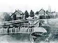 The first Soo Locks in the 19th century
.jpg.webp) Anchor Line steamer in the Soo Locks, ca. 1900s
Anchor Line steamer in the Soo Locks, ca. 1900s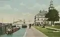 A whaleback traverses the Poe Lock, ca. 1910
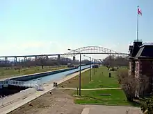 Canadian Lock at Sault Ste. Marie, Ontario
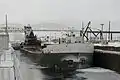 The last ship of the 2013 season passes through the Poe Lock
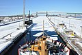 USCGC Mackinaw passes through Soo Locks
References
- 33 CFR 207.440
- 33 CFR 207.441
- "National Register Information System". National Register of Historic Places. National Park Service. January 23, 2007.
- "St. Marys Falls Canal". National Historic Landmark summary listing. National Park Service. Archived from the original on October 6, 2012. Retrieved June 27, 2008.
- State Historic Preservation Office (2009). "Saint Mary's Falls Canal". Historic Sites Online. Michigan State Housing Development Authority. Archived from the original on May 11, 2012. Retrieved June 26, 2010.
- Detroit District. "Facts". United States Army Corps of Engineers. Archived from the original on January 10, 2011. Retrieved October 22, 2008.
- "NHL nomination for St. Marys Falls Canal". National Park Service. Retrieved April 3, 2017.
- Conn, Stetson; Engelman, Rose C.; Fairchild, Byron (2000) [1964]. Guarding the United States and its Outposts. United States Army in World War II. Washington, D.C.: Center of Military History, United States Army. pp. 102–105.
- Saint Marys Falls Ship Canal (Soo Locks Historic District, Soo Canals), Michigan Department of Labor and Economic Opportunity, 2020.
- Lange, Alex, "The Mighty Soo: Construction of the Locks at Sault Ste. Marie, Michigan", The Unwritten Record. National Archives, January 5, 2017.
- David Helwig (March 30, 2002). "$227 million lock replacement could start this year". SooToday.com.
- Arbic, Bernard; Steinhaus, Nancy (2005). Upbound Downbound: The Story of the Soo Locks. Allegan Forest, MI: Priscilla Press. pp. 35–37.
- "Seeing The Light: Orlando Metcalfe Poe". Terrypepper.com. May 30, 2000. Retrieved April 10, 2012.
- United States Army Corps of Engineers. "Traffic Statement: 2008 Navigation Season". p. 3. Archived from the original on July 10, 2009. Retrieved August 30, 2009.
- "Construction beginning on new Soo shipping lock". Detroit Free Press. June 30, 2009. Archived from the original on July 7, 2009. Retrieved July 13, 2009.
- "President signs legislation authorizing funding for new Soo Lock". Boatnerd.com - Great Lakes & Seaway Shipping News Archive. October 24, 2018. Retrieved December 20, 2018.
- "Construction begins this week on new Poe-sized lock at the Soo Locks". WXYZ. May 7, 2020. Retrieved September 21, 2020.
- "Chapter 4: The Watery Boundary". United Divide: A Linear Portrait of the USA/Canada Border. The Center for Land Use Interpretation. Winter 2015.
- Detroit District. "Soo Locks: Sault Ste- Marie". United States Army Corps of Engineers. Archived from the original on January 31, 2011. Retrieved March 5, 2011.
- "Soo Locks Engineer's Day". June 24, 2010. Retrieved March 5, 2011.
- Parks Canada. "Sault Ste. Marie Canal National Historic Site of Canada, Natural Wonders & Cultural Treasures". Parks Canada. Archived from the original on July 18, 2006.
Further reading
- Taylor, Paul (2009). Orlando M. Poe: Civil War General and Great Lakes Engineer. Kent State University Press. ISBN 978-1-60635-040-9.
External links
| Wikimedia Commons has media related to Soo Locks. |
- Aerial views
- Soo Locks homepage U.S. Army Corps of Engineers Soo Locks page
- Web Camera view of the American locks NOTE: This Connection is Untrusted
- Animation of how the Soo Locks work.
- YouTube video HD video of a ship passing through the MacArthur Lock
| Central cities | |
|---|---|
| Counties | |
| Geography | |
| Transportation | |
| Economy | |
| Authority control |
|---|