Skardu–Kargil Road
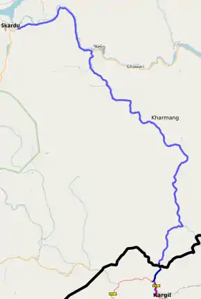
The Skardu–Kargil Road (Urdu: سکردو – کرگل سڑک) is 126 km provincial highway in the Pakistan-administered region of Gilgit-Baltistan running from Skardu, via Kharmang, to the Line of Control with Indian-administered Kashmir.[1] The original road continued on to Kargil, but has been closed down since 1948.[2]
| Skardu–Kargil Road سکردو – کرگل سڑک | |
|---|---|
 | |
| Route information | |
| Maintained by Planning & Development Department | |
| Length | 126 km (78 mi) |
| Major junctions | |
| From | Skardu |
| To | Kharmang |
| Highway system | |
| Roads in Pakistan | |
History
The road from Skardu to Kargil was part of the ancient Silk Route.[3]
Prior to the Partition of India, the regions of Kargil, Leh and Baltistan constituted the Ladakh Wazarat of the princely state of Jammu and Kashmir. During the First Kashmir War, Kargil and Baltistan came under the control of India and Pakistan respectively. The 1949 ceasefire line separated the two regions. Many families still trace their immediate ancestors on the other side of the border.[3]
Many people from both sides of the Line of Control seek to have the road reopened to traffic.[4][5]
References
- http://www.dailytimes.com.pk/opinion/01-Sep-2015/opening-the-kargil-skardu-road
- Khan, M Ismail (9 May 2006). "Political debris blocking the Skardu-Kargil road". The News. Pakistan. Retrieved 26 October 2020.
- Haidar Ali Askary, Kargil-Skardu Road: Only Connect, Greater Kashmir, 24 May 2015.
- https://www.dawn.com/news/198840/refugees-seek-opening-of-skardu-kargil-road
- https://www.dawn.com/news/615159