Skillounta
Skillounta is a former municipality in Elis, West Greece, Greece. Since the 2011 local government reform it is part of the municipality Andritsaina-Krestena, of which it is a municipal unit.[2] The municipal unit has an area of 194.409 km2.[3] It is named after the ancient town Scillus, which was located in the area. Its seat of administration was in the town Krestena. The territory of the municipal unit Skillounta stretches from the plains on the Ionian Sea coast to the forested mountains of southeastern Elis. The river Alfeios forms its northern border. Krestena is 6 km south of Olympia, 12 km north of Zacharo and 18 km southeast of Pyrgos. The Greek National Road 9/E55 (Patras - Pyrgos - Kyparissia) passes through Kallikomo in the western part of Skillounta, and the Greek National Road 76 to Andritsaina and Megalopoli runs west to east through Krestena and Graikas.
Skillounta
Σκιλλούντα | |
|---|---|
 Skillounta Location within the regional unit 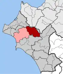 | |
| Coordinates: 37°37′N 21°38′E | |
| Country | Greece |
| Administrative region | West Greece |
| Regional unit | Elis |
| Municipality | Andritsaina-Krestena |
| • Municipal unit | 194.4 km2 (75.1 sq mi) |
| Elevation | 276 m (906 ft) |
| Population (2011)[1] | |
| • Municipal unit | 10,303 |
| • Municipal unit density | 53/km2 (140/sq mi) |
| Time zone | UTC+2 (EET) |
| • Summer (DST) | UTC+3 (EEST) |
| Postal code | 270 55 |
| Area code(s) | 26250 |
| Vehicle registration | ΗΑ |
Subdivisions
The municipal unit Skillounta is subdivided into the following communities (constituent villages in brackets):
- Diasella (Diasella, Ladikaki, Papa Chania, Skala)
- Frixa (Frixa, Anemochoraki)
- Graikas
- Gryllos (Gryllos, Chani Gryllou)
- Kallikomo (Kallikomo, Krounoi, Ladiko)
- Kalyvakia (Nea Kalyvakia)
- Kato Samiko (Kato Samiko, Kleidi, Fragkokklisia)
- Krestena (Krestena, Moschoula, Poros)
- Makrisia
- Platiana
- Ploutochori (Neo Chorio)
- Raches
- Samiko
- Skillountia (Skillountia, Nea Skillountia)
- Trypiti (Trypiti, Lekani)
- Vrina
Sites of interest
- Iardanos Tomb - situated near the village Kleidi, community of Kato Samiko. It was excavated in 1954 and contained 16 graves.[4]
Population
| Year | Municipal unit |
|---|---|
| 1991 | 14,449 |
| 2001 | 15,931 |
| 2011 | 10,303 |
See also
References
- "Απογραφή Πληθυσμού - Κατοικιών 2011. ΜΟΝΙΜΟΣ Πληθυσμός" (in Greek). Hellenic Statistical Authority.
- Kallikratis law Greece Ministry of Interior (in Greek)
- "Population & housing census 2001 (incl. area and average elevation)" (PDF) (in Greek). National Statistical Service of Greece.
- Website
External links
Places adjacent to Skillounta | ||||||||||
|---|---|---|---|---|---|---|---|---|---|---|
| ||||||||||
