Volakas, Elis
Volakas (Greek: Βώλακας) is a former municipality in Elis, West Greece, Greece. After the administrative reform of 2011, it became a part of Pyrgos.[2] The municipal unit has an area of 70.790 km2.[3] Its seat of administration was in the town of Epitalio.
Volakas
Βώλακας | |
|---|---|
 Volakas Location within the regional unit 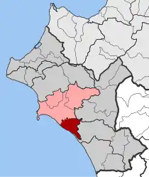 | |
| Coordinates: 37°37′N 21°30′E | |
| Country | Greece |
| Administrative region | West Greece |
| Regional unit | Elis |
| Municipality | Pyrgos |
| • Municipal unit | 70.79 km2 (27.33 sq mi) |
| Elevation | 37 m (121 ft) |
| Population (2011)[1] | |
| • Municipal unit | 2,935 |
| • Municipal unit density | 41/km2 (110/sq mi) |
| Time zone | UTC+2 (EET) |
| • Summer (DST) | UTC+3 (EEST) |
| Postal code | 270 58 |
| Area code(s) | 26210 |
| Vehicle registration | ΗΑ |
| Website | www |
Volakas is situated on the Ionian Sea coast, southeast of Pyrgos and southwest of Olympia. The river Alfeios forms the northern border of the municipal unit. There are wooded hills in the northeastern part of Volakas, the southwestern part along the coast is flat and used for agriculture. The Greek National Road 9 (Patras - Pyrgos - Kyparissia) and the railway from Pyrgos to Kalamata run through Volakas. Operations at the small airport of Epitalio (ICAO: LGEP) have been suspended.[4]
Subdivisions
The municipal unit Volakas was subdivided into the following communities (constituent villages in brackets):
Historical population
| Year | Population |
|---|---|
| 1991 | 3,438 |
| 2001 | 3,552 |
| 2011 | 2,935 |
See also
References
- "Απογραφή Πληθυσμού - Κατοικιών 2011. ΜΟΝΙΜΟΣ Πληθυσμός" (in Greek). Hellenic Statistical Authority.
- Kallikratis law Greece Ministry of Interior (in Greek)
- "Population & housing census 2001 (incl. area and average elevation)" (PDF) (in Greek). National Statistical Service of Greece.
- Greek Civil Aviation Authority
External links
- Volakas municipal unit (in Greek)
Places adjacent to Volakas, Elis | ||||||||||
|---|---|---|---|---|---|---|---|---|---|---|
| ||||||||||