Sky Gate Bridge R
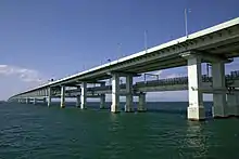
Sky Gate Bridge R (スカイゲートブリッジR), also known as the Kansai International Airport Access Bridge (関西国際空港連絡橋), serves as a link between the mainland of Osaka, Japan to the artificial island in Osaka Bay on which Kansai International Airport is built. It is the longest double-decked truss bridge in the world. The bridge carries six lanes of automobile traffic on top and two of rail below, over nine truss spans.
Sky Gate Bridge R スカイゲートブリッジR | |
|---|---|
 | |
| Coordinates | 34.426333°N 135.278361°E |
| Carries | S Kansai Airport Line, |
| Crosses | Osaka Bay |
| Locale | Izumisano, Osaka, |
| Official name | 関西国際空港連絡橋 (Kansai Kokusai Kūkō Renrakukyō) |
| Characteristics | |
| Design | Continuous truss bridge |
| Total length | 3,750 m (12,300 ft)[1] |
| Width | 29.5 m (97 ft) |
| Height | 25 m (82 ft) |
| Longest span | 150 m (490 ft) |
| History | |
| Opened | 1991 |
| Statistics | |
| Toll | ¥920[2] |
| Location | |

| |
 | |
|---|---|
| Route information | |
| Length | 4.6 km[3] (2.9 mi) |
| Existed | 2009–present |
| Component highways | |
| Major junctions | |
| South end | Rinku Junction in Izumisano, Osaka |
| North end | Kansai International Airport Interchange in Izumisano, Osaka |
| Highway system | |
| National highways of Japan Expressways of Japan | |

Structural specifications
The Sky Gate Bridge is a continuous truss bridge that measures 3,750 meters long, 29.5 meters wide (6 lanes), and 25 meters at its highest point in the center.[1][4]
History
The bridge commenced construction in June 1987, and was completed in March 1994.[1] On 21 April 2009, management of the expressway portion of the bridge was handed over to the West Nippon Expressway Company.[3] This expressway was numbered E71 alongside the Kansai-Kūkō Expressway in 2016.[5]
Typhoon Jebi
The bridge was damaged on 4 September 2018, by Typhoon Jebi. A 2600-ton tanker lost power and was blown into one side, severely damaging half of the automobile lanes and the rail lines.[6] The bridge, being the sole link between the airport and the mainland, stranded approximately 3000 passengers and 2000 staff[7] overnight at the airport. They were evacuated the next day via the Kōbe–Kankū Bay Shuttle (神戸-関空ベイ・シャトル) ferry to nearby Kobe Airport,[8] later joined by buses over the undamaged half of the bridge.[7] The bridge was partially reopened to vehicle traffic on 7 March 2019 with four lanes open.[9] The bridge's full capacity with six lanes of traffic was restored on 8 April 2019.[10]
Junction list
The entire expressway is in Osaka Prefecture. The sequence of kilometer posts continue from the Kansai-Kūkō Expressway.
| Location | km[11] | mi | Exit | Name | Destinations | Notes | |
|---|---|---|---|---|---|---|---|
| Izumisano | 6.6 | 4.1 | 3 | Rinkū | Southern terminus, E71 continues on to the Kansai-Kūkō Expressway | ||
| 6.6 | 4.1 | 4 | Rinku | Osaka Prefecture Route 29 east – Kaizuka Osaka Prefecture Route 63 south – Sennan | Northbound entrance, southbound exit; southern end of National Route 481 concurrency | ||
| 11.2 | 7.0 | 5 | Kansai International Airport | Northern terminus of E71 and National Route 481; toll gate | |||
1.000 mi = 1.609 km; 1.000 km = 0.621 mi
| |||||||
References
- "About Kansai International Airport". Kansai Airports. Retrieved 27 February 2018.
- "Road Map and Access Bridge Tolls". Kansai Airports. Retrieved 5 September 2018.
- "関西国際空港連絡橋(道路)の移管に伴う料金変更について" (in Japanese). 21 April 2009. Retrieved 30 October 2019.
- "LONG SPAN & NEWER STEEL BRIDGES IN JAPAN". Daido University. Retrieved 6 September 2018.
- "Japan's Expressway Numbering System". www.mlit.go.jp. Retrieved 30 October 2019.
- "Ship smashes into Kansai airport bridge as typhoon hits Japan". The Mainichi. 4 September 2018. Retrieved 4 September 2018.
- Williams, Martin (7 September 2018). "What Kansai airport flooding can teach Hong Kong about the perils of reclamation amid climate change". South China Morning Post.
- "First of 5,000 people stranded by typhoon at Kansai airport evacuated as storm death toll hits 10". The Japan Times. 5 September 2018.
- "関西空港自動車道" (in Japanese). Retrieved 29 October 2019.
- "関西国際空港連絡橋 6車線確保について" (PDF) (in Japanese). Retrieved 12 May 2019.
- Google (30 October 2019). "Kansai Int'l Airport Access Bridge" (Map). Google Maps. Google. Retrieved 30 October 2019.
| Wikimedia Commons has media related to Sky Gate Bridge R. |