Osaka Prefecture
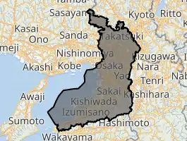
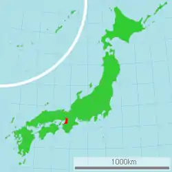
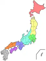
Osaka Prefecture (大阪府, Ōsaka-fu, pronounced [oːsaka ɸɯ]) is a prefecture of Japan located in the Kansai region of Honshu.[1] Osaka Prefecture has a population of 8,823,358 (as of 1 June 2019) and has a geographic area of 1,905 square kilometres (736 sq mi). Osaka Prefecture borders Hyōgo Prefecture to the northwest, Kyoto Prefecture to the north, Nara Prefecture to the southeast, and Wakayama Prefecture to the south.
Osaka Prefecture
大阪府 | |||||||||||||
|---|---|---|---|---|---|---|---|---|---|---|---|---|---|
| Japanese transcription(s) | |||||||||||||
| • Japanese | 大阪府 | ||||||||||||
| • Rōmaji | Ōsaka-fu | ||||||||||||
 Flag  Symbol | |||||||||||||
| |||||||||||||
 | |||||||||||||
| Coordinates: 34°41′11″N 135°31′12″E | |||||||||||||
| Country | |||||||||||||
| Region | Kansai | ||||||||||||
| Island | Honshu | ||||||||||||
| Capital | Osaka | ||||||||||||
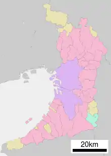
| Subdivisions | Districts: 5, Municipalities: 43 | ||||||||||||
| Government | |||||||||||||
| • Governor | Hirofumi Yoshimura | ||||||||||||
| Area | |||||||||||||
| • Total | 1,905.14 km2 (735.58 sq mi) | ||||||||||||
| Area rank | 46th | ||||||||||||
| Population (July 1, 2019) | |||||||||||||
| • Total | 8,823,358 | ||||||||||||
| • Rank | 3rd | ||||||||||||
| • Density | 4,600/km2 (12,000/sq mi) | ||||||||||||
| ISO 3166 code | JP-27 | ||||||||||||
| Website | www | ||||||||||||
| |||||||||||||
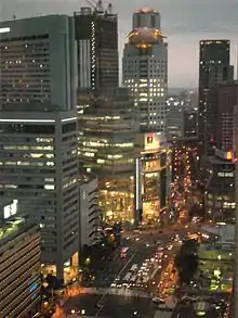
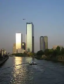
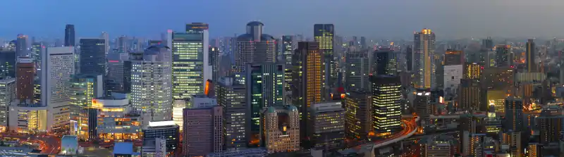
Osaka is the capital and largest city of Osaka Prefecture, and the third-largest city in Japan, with other major cities including Sakai, Higashiōsaka, and Hirakata.[2] Osaka Prefecture is the third-most-populous and second-smallest prefecture by geographic area, and at 4,600 inhabitants per square kilometre (12,000/sq mi) is the second-most densely populated after Tokyo. Osaka Prefecture is one of Japan's two "urban prefectures" using the designation fu (府) rather than the standard ken for prefectures, along with Kyoto Prefecture. Osaka Prefecture forms the center of the Keihanshin metropolitan area, the second-most-populated urban region in Japan after the Greater Tokyo area and one of the world's most productive regions by GDP.
History
| Year | Pop. | ±% p.a. |
|---|---|---|
| 1890 | 1,324,216 | — |
| 1903 | 1,823,456 | +2.49% |
| 1913 | 2,461,067 | +3.04% |
| 1920 | 2,587,847 | +0.72% |
| 1925 | 3,059,502 | +3.41% |
| 1930 | 3,540,017 | +2.96% |
| 1935 | 4,297,174 | +3.95% |
| 1940 | 4,792,966 | +2.21% |
| 1945 | 2,800,958 | −10.19% |
| 1950 | 3,857,047 | +6.61% |
| 1955 | 4,618,308 | +3.67% |
| 1960 | 5,504,746 | +3.57% |
| 1965 | 6,657,189 | +3.87% |
| 1970 | 7,620,480 | +2.74% |
| 1975 | 8,278,925 | +1.67% |
| 1980 | 8,473,446 | +0.47% |
| 1985 | 8,668,095 | +0.46% |
| 1990 | 8,734,516 | +0.15% |
| 1995 | 8,797,268 | +0.14% |
| 2000 | 8,805,081 | +0.02% |
| 2005 | 8,817,166 | +0.03% |
| 2010 | 8,865,245 | +0.11% |
| 2015 | 8,838,908 | −0.06% |
| source:[3] | ||
Until the Meiji Restoration, the area of Osaka prefecture was known as Kawachi, Izumi,[4][5] and Settsu provinces.[6]
Osaka Prefecture was created on June 21, 1868, at the very beginning of the Meiji era.[7] During the instigation of Fuhanken Sanchisei in 1868, the prefecture received its suffix fu, designating it as an prefecture.
On September 1, 1956, the city of Osaka was promoted to a city designated by government ordinance and thereby divided into 24 wards.
In 2000, Fusae Ota became Japan's first female governor when she replaced Knock Yokoyama, who resigned after prosecution for sexual harassment.[8]
On April 1, 2006: the city of Sakai was promoted to a city designated by government ordinance and thereby divided into seven wards.
In 2008, Tōru Hashimoto, previously famous as a counselor on television, was elected at the age of 38 as the youngest governor in Japan.
06/18/2018 - 2018 Osaka earthquake.
Reform
In 2010, the Osaka Restoration Association was created with backing by Governor Tōru Hashimoto, attempting to reform Osaka Prefecture into Osaka Metropolis reducing affiliated organizations of Osaka Prefecture and the City of Osaka.
In the 2011 local elections the association was able to win the majority of the prefectural seats.
The plan was narrowly defeated in the 2015 referendum (49.62% yes and 50.38% no).
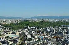
Geography
Osaka Prefecture neighbors the prefectures of Hyōgo and Kyoto in the north, Nara in the east and Wakayama in the south. The west is open to Osaka Bay. The Yodo and Yamato Rivers flow through the prefecture.
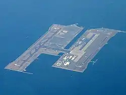
Prior to the construction of Kansai International Airport, Osaka was the smallest prefecture in Japan. The artificial island on which the airport was built added enough area to make it slightly larger than Kagawa Prefecture.[9][10]
As of 1 April 2012, 11% of the total land area of the prefecture was designated as Natural Parks, namely Kongō-Ikoma-Kisen and Meiji no Mori Minō Quasi-National Parks and Hokusetsu and Hannan-Misaki Prefectural Natural Parks.[11]
Cities
Government Ordinance Designated City City Town Village
Thirty-three cities are located in Osaka Prefecture:
Towns and villages
These are the towns and villages in each district:
Mergers
Economy
The gross prefecture product of Osaka for the fiscal year 2004 was ¥38.7 trillion, second after Tokyo with an increase of 0.9% from the previous year. This represented approximately 48% of the Kinki region. The per capita income was ¥3.0 million, seventh in the nation.[12] Commercial sales the same year was ¥60.1 trillion.[13]
Overshadowed by such globally renowned electronics giants as Panasonic and Sharp, the other side of Osaka's economy can be characterized by its Small and Medium Enterprises (SMEs) activities. The number of SMEs based in Osaka in 2006 was 330,737, accounting for 99.6% of the total number of businesses in the prefecture.[14] While this proportion is similar to other prefectures (the average nationwide was 99.7%), the manufactured output of the SMEs amounted to 65.4% of the total within the prefecture, a rate significantly higher than Tokyo's 55.5%, or Kanagawa's 38.4%.[15] One model from Osaka of serving the public interest and restimulating the regional economy, combined with industry-education cooperation efforts, is the Astro-Technology SOHLA,[16] with its artificial satellite project.[17] Having originally started from a gathering of Higashiosaka based SMEs, Astro-Technology SOHLA has not only grown into a Kansai region-wide group but has also won support from the government, through technology and material support from Japan Aerospace Exploration Agency (JAXA),[18] and financial support from NEDO.[19][20]
The Osaka Securities Exchange, specializing in derivatives such as Nikkei 225 Futures, is based in Osaka.
There are many electrical, chemical, pharmaceutical, heavy industry, food, and housing companies in Osaka Prefecture.
Major factories and research institutes
Demographics
According to the 2005 Population Census of Japan, Osaka prefecture has a population of 8,817,166, an increase of 12,085, or 0.14%, since the Census of year 2000.[21]
As of 2013 this prefecture has about 200,000 ethnic Korean persons, the largest such population of any prefecture in Japan. Osaka City. As of 2013 most ethnic Korean children attend ordinary Japanese public schools, although some Korean schools operated by the Chongryon and classes for ethnic Koreans had opened in the prefecture. During the Japanese rule of Korea many ethnic Koreans came to the Osaka area to look for work. Many people from Jeju came to the Osaka area after a 1922 ferry line between Osaka and Jeju opened. During World War II Japanese authorities forced additional ethnic Koreans to move to the Osaka area.[22]
Temples and shrines
Museums
- National Museum of Ethnology, Japan
- Open-Air Museum of Old Japanese Farm Houses (Hattori Ryokuchi Park)
- OSTEC (Osaka Science and Technology Center) Exhibition Hall
- Japan Folk Crafts Museum, Osaka
Education
Public elementary and junior high schools in the prefecture are operated by the municipalities. Public high schools are operated by the Osaka Prefectural Board of Education.
Universities
- Kansai Medical University (Hirakata, Osaka)
- Osaka University (Toyonaka and Suita)
- former Osaka University of Foreign Studies (Minoh)
- Osaka Kyoiku University (Kashiwara)
- Osaka City University (Osaka city)
- Osaka Prefecture University (Sakai)
- Kansai University (Suita, Takatsuki, Osaka city)
- Kindai University (Higashiosaka)
- Kansai Gaidai University (Hirakata) (Kansai University of Foreign Studies)
- Osaka International Educational University (Moriguchi)
- Osaka University of Health and Sport sciences (Kumatori)
- Osaka University of Commerce (Higashiosaka)
- Osaka University of Economic and Law (Yao)
- Osaka College of Music (Toyonaka)
- Osaka Electro Communication University (Neyagawa)
- Osaka Gakuin University (Suita)
- Otemon Gakuin University (Ibaraki)
- Hannan University (Matsubara)
- Setsunan University (Neyagawa)
- St Andrews University (Momoyama Gakuin University) (Izumi)
- Taisei Gakuin University (Mihara, Sakai)
- Tezukayama Gakuin University (Ōsakasayama, Sakai)
Parks
- The Expo Commemoration Park (Suita) Expo '70 held here. About 260 ha. Includes a Japanese garden, National Museum of Art, Osaka, and the amusement park "Expoland".
- Hattori Ryokuchi Park (Toyonaka) about 150 ha.
- Tsurumi Ryokuchi Park (Osaka) about 100 ha. Expo '90 of horticulture held here.[23]
- Nagai Park (Osaka) about 66 ha. The IAAF World Championships in Athletics were held in 2007 at Nagai Stadium in this park.
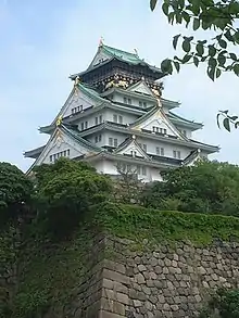
- Osaka Castle Park (Osaka) about 106 ha.
- Nakanoshima Park (Osaka) - The Museum of Oriental Ceramics, public hall (1911, Renaissance Revival architecture), Osaka Prefectural Nakanoshima Library (1904, Baroque Revival architecture), and the city hall of Osaka.
- Yamadaike Park (Osaka) about 73.7 hectares. Osaka Prefectural Park in Hirakata City, Osaka Prefecture. Operated by Osaka Prefecture.
Transportation
Rail
People movers
Expressways
- Meishin Expressway
- Chugoku Expressway
- Hanshin Expressway
- Nishi-Meihan Expressway
- Second Keihan Highway
- Hanwa Expressway
- Second Hanna Highway
- Minami Hanna Highway
National highways
- National Route 1
- National Route 2
- National Route 25
- National Route 26
- National Route 43
- National Route 163
- National Route 165
- National Route 166
- National Route 168
- National Route 170
- National Route 171
- National Route 173
- National Route 176
- National Route 307
- National Route 308
- National Route 309
- National Route 310
- National Route 371
- National Route 423
- National Route 477
- National Route 479
- National Route 480
- National Route 481
Airports
- Osaka International Airport - Domestic flights
- Kansai International Airport - International and domestic flights
Sports
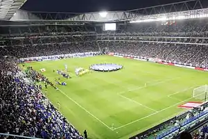
The sports teams listed below are based in Osaka.
League
Non-league
Baseball
Basketball
Rugby union
Prefectural symbols
The symbol of Osaka Prefecture, called the sennari byōtan or "thousand gourds," was originally the crest of Toyotomi Hideyoshi, the feudal lord of Osaka Castle.
See also
Notes
- Nussbaum, Louis-Frédéric. (2005). "Osaka-fu" in Japan Encyclopedia, p. 759, p. 759, at Google Books; "Kansai" in p. 477, p. 477, at Google Books
- Nussbaum, "Osaka" in p. 759, p. 759, at Google Books
- Statistics Bureau of Japan
- 大阪府教育委員会 (2002-03-29). "岸和田城跡". Comprehensive Database of Archaeological Site Reports in Japan. Retrieved 2016-09-02.
- 泉南市教育委員会 (1987-09-21). "海会寺". Comprehensive Database of Archaeological Site Reports in Japan. Retrieved 2016-09-02.
- Nussbaum, "Provinces and prefectures" in p. 780, p. 780, at Google Books
- "大阪のあゆみ (History of Osaka)" (in Japanese). Retrieved 2007-03-12.The creation of Osaka prefecture took place slight earlier than many other prefectures, that had to wait for abolition of the han system in 1871.
- Tolbert, Kathryn. "Election of First Female Governor Boosts Japan's Ruling Party", The Washington Post, February 8, 2000.
- "平成10年全国都道府県市区町村の面積の公表について(Official announcement on the national territory and area of 1998, by prefectures, cities, districts, towns and villages)" Archived 2003-06-11 at the Wayback Machine, Geographical Survey Institute, Government of Japan, January 29, 1999.
- "コラム Vol.017 全国都道府県市区町村面積調 (Column: "National Area Investigation" vol.017)" Archived 2007-09-28 at the Wayback Machine, Alps Mapping K.K., March 8, 2001.
- "General overview of area figures for Natural Parks by prefecture" (PDF). Ministry of the Environment. Retrieved 9 August 2012.
- "平成16年度の県民経済計算について (Prefectural Economy for the fiscal year 2004 based on 93SNA) Cabinet Office, Government of Japan" (PDF) (in Japanese). Archived from the original (PDF) on 2007-06-14. Retrieved 2007-03-13.
- "大阪府民経済計算 (Osaka Prefectural Economy based on 93SNA) Osaka Prefectural Government" (PDF) (in Japanese). Archived from the original (PDF) on 2007-06-14. Retrieved 2007-03-13.
- "2006 White Paper on Small and Medium Enterprises in Japan, Japan Small Business Research Institute (Japan)" (PDF). Archived from the original (PDF) on 2007-03-23. Retrieved 2007-03-13.
- "なにわの経済データ (The Naniwa Economy Data)" (PDF) (in Japanese). Archived from the original (PDF) on 2007-06-14. Retrieved 2007-03-13.
- "Astro-Technology SOHLA" (in Japanese). Archived from the original on 2007-03-09. Retrieved 2007-03-14.
- "Japan Advertising Council". Archived from the original on 2007-03-01. Retrieved 2007-03-14. For details on the campaign featuring SOHLA, navigate through the Japanese page to the 2003 campaign listing, at entry "東大阪の人工衛星" (Higashiosaka's Satellite) Archived 2007-03-12 at the Wayback Machine
- ""Smaller firms build a satellite" City of Osaka, Chicago Office". Archived from the original on 2007-09-29. Retrieved 2007-03-14.
- The New Energy and Industrial Technology Development Organization
- ""Study of PETSAT" NEDO, 2005" (PDF) (in Japanese and English). Archived from the original (PDF) on 2007-06-14. Retrieved 2007-03-14.
- "Table 1: 大阪府の人口の推移 ( Population Change of Osaka Prefecture)" (in Japanese). Osaka Prefectural Government. Archived from the original on 2007-01-05. Retrieved 2007-03-13.
- Aoki, Eriko. "Korean children, textbooks, and educational practices in Japanese primary schools" (Chapter 8). In: Ryang, Sonia. Koreans in Japan: Critical Voices from the Margin (Routledge Studies in Asia's Transformations). Routledge, October 8, 2013. ISBN 1136353054, 9781136353055. Start: p. 157. CITED: p. 166.
- 財団法人 国際花と緑の博覧会記念協会:English:Expo'90 Foundation Archived 2011-10-21 at the Wayback Machine
References
- Nussbaum, Louis-Frédéric and Käthe Roth. (2005). Japan encyclopedia. Cambridge: Harvard University Press. ISBN 978-0-674-01753-5; OCLC 58053128
External links
| Wikimedia Commons has media related to Osaka prefecture. |
- Official Osaka Prefecture homepage
- Osaka Tourism & Convention Guidance homepage
- Comprehensive Database of Archaeological Site Reports in Japan
| Osaka |
| |||
|---|---|---|---|---|
| Sakai |
| |||
| Core cities | ||||
| Special cities | ||||
| Cities | ||||
| Districts | ||||
List of mergers in Osaka Prefecture; Note: ☆ - Cities to become core cities | ||||
| Authority control |
|---|