Slawharad
Slawharad or Slavgorod (Belarusian: Слаўгарад; Russian: Славгород, Polish: Sławograd) is a town in the Mogilev Region, Eastern Belarus. It is located in the east of the Region, on the banks of the Sozh River at the confluence with the Pronya River, and serves as the administrative center of the Slawharad District. As of 2009, its population was 7,992.[1]
Slawharad
Слаўгарад Славгород | |
|---|---|
| Slawharad Slavgorod | |
 Church of the Nativity of the Theotokos (1791-1793) | |
 Flag  Coat of arms | |
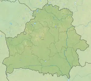 Slawharad Location of Slawharad in Belarus | |
| Coordinates: 53°26′N 31°00′E | |
| Country | |
| Region | Mogilev Region |
| District | Slawharad District |
| Population (2009) | |
| • Total | 7,992 |
| Time zone | UTC+2 (EET) |
| • Summer (DST) | UTC+3 (EEST) |
| License plate | 6 |
History
Slawharad was first mentioned in the chronicles in 1136 as Prupoy. It was also mentioned later under the names of Proposhensk, Propolsk, and Propoysk. In the 14th century, Propoysk became a part of the Grand Duchy of Lithuania, and eventually of Poland, where it was a part of Mstsislaw Voivodeship. Propoysk was badly damaged during the Russo–Polish War (1654–67). In September 1772, as a result of the First Partition of Poland, the town was transferred to the Russian Empire and became a part of Mogilev Governorate.[2] It was the center of Propoyskaya Volost of Bykhovsky Uyezd. As of 1881, the population of Propoysk was 3400. In the 19th century, the town was one of major centers of iron production, however, the production stopped in 1872. It was also an important river port.[2]
In 1919, Mogilev Governorate was abolished, and Slawharad was transferred to Gomel Governorate. On July 17, 1924, the governorate was abolished as well, and Propoysk became the administrative center of Propoysk Raion, which belonged to Mogilev Okrug of Byelorussian Soviet Socialist Republic. On January 15, 1938, the raion was transferred to Mogilev Region.[3] In January 1939, the population of Propoysk included 1,038 Jews, 22 percent of the total population.[4] During the Second World War, the town was occupied by German troops and severely damaged. The Jews of the town were murdered in several operations in November 1941.
On May 23, 1945, Propoysk was renamed Slawharad (Slavgorod), and Propoysk Raion was renamed Slawharad Raion. In 1986, it was considerably affected by the Chernobyl disaster.
Economy
Industry

The industry in Slawharad produces food and serves local agriculture.[5]
Culture and recreation
The Propoysk Castle did not survive, but its location, the Castle Hill, between the Sozh and the Pronya, is an archaeological monument. There are several monuments of architecture which were built in the 18th and the 19th century. The most notable one is the Church of the Nativity of the Theotokos (1791-1793), located close to the Castle Hill.[6]
References
![]() Media related to Slaŭharad at Wikimedia Commons
Media related to Slaŭharad at Wikimedia Commons
- Численность населения областей и районов: Могилевская (PDF) (in Russian). Национальный статистический комитет Республики Беларусь. Archived from the original (PDF) on 18 September 2010. Retrieved 30 January 2012.
- История (in Russian). Славгородский районный исполнительный комитет. Archived from the original on 4 December 2013. Retrieved 11 February 2012.
- Административно-территориальное деление Беларуси (in Russian). Белорусский научно-исследовательский центр электронной документации. Retrieved 12 February 2012.
- http://www.yadvashem.org/untoldstories/database/index.asp?cid=180
- Экономика (in Russian). Славгородский районный исполнительный комитет. Retrieved 12 February 2012.
- Славгород (in Russian). Глобус Беларуси. Retrieved 12 February 2012.
External links
- The murder of the Jews of Slawharad during World War II, at Yad Vashem website.
| Districts (raiony) |  | |
|---|---|---|
| Cities and towns | ||