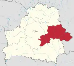
Mogilev Region
Mogilev Region or Mogilev Oblast or Mahilyow Voblasts (Belarusian: Магілёўская во́бласць; Mahilioŭskaja voblasć; Russian: Могилёвская о́бласть; Mogilyovskaya Oblast), is a region (oblast) of Belarus with its administrative center at Mogilev (Mahilyow).
Mogilev Region
Mogilev Oblast, Mahilyow Voblasts | |
|---|---|
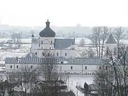 The Saint Nicholas Monastery, Mogilev | |
 Flag  Coat of arms | |
 | |
| Administrative center | Mogilev |
| Largest cities | Mogilev - 365,100 Babruysk - 220,800 Asipovichy - 34,700 |
| Raions | 21 Towns - 14 Urban localities - 12 |
| City raions | 3 |
| Government | |
| • Chairman | Leonid Zayats [1] |
| Area | |
| • Total | 29,079.01 km2 (11,227.47 sq mi) |
| Highest elevation | 239 m (784 ft) |
| Lowest elevation | 126 m (413 ft) |
| Population (2019) | |
| • Total | 1,052,877 |
| • Density | 37/km2 (100/sq mi) |
| ISO 3166 code | BY-MA |
| HDI (2018) | 0.796[2] high · 6th |
| Website | mogilev-region |
Both Mogilev and Gomel Regions suffered severely after the Chernobyl nuclear radioactive reactor catastrophe in April 1986.
Important cities within the region include Mogilev, Asipovichy and Babruysk.
Geography
The Mogilev Region covers a total area of 29,100 km2 (11,200 sq mi),[3] about 14% of the national total. The oblast's greatest extent from north to south is 150 km (93 mi), from east to west - 300 km (190 mi), while the highest point is 239 metres (784 ft) above sea level and the lowest at 126 m (413 ft) above sea level.
Many rivers flow through the Mogilev Region including the Dnieper (Dniapro), Berezina, Sozh, Druts, Pronya and Ptsich. The oblast' also has small lakes, the largest being the Zaozerye Lake with a surface area of 0.58 km2 (0.22 sq mi). The Chihirin Reservoir on the Druts River has an area of 21.1 km2 (8.1 sq mi).
The extreme eastern point of Belarus is situated within the Mogilev Region to the east of the Khotimsk District.[4]
Climate
Mogilev Region has a temperate continental climate. The region has cold winters and warm summers. January's average temperature reaches from −8.2 °C (17.2 °F) in the northeast to −6.5 °C (20.3 °F) in the southwest. July's average temperature reaches from 17.8 °C (64.0 °F) in the northeast to 18.7 °C (65.7 °F) in the southwest. The region's average yearly vegetative period lasts around 183–194 days. The average precipitation is 575–675 millimetres (22.6–26.6 in) a year with approximately 70% falling during the warm season (April–October).
Demographics
With a total population of 1,088,100 (2011),[3] 353,600 inhabitants live in rural areas and 855,000 live in cities or towns. There are 639,300 women and 567,300 men in the region, of which 288,100 are under 18 while 267,300 are elderly people.
Of the major nationalities living in the Mogilev Region, 1,044,000 inhabitants are Belarusians, 132,000 are Russians, 3,500 are Jewish, 2,800 are Poles, 2,110 are Ukrainians, 1,700 are Tatars, 1,300 are Lithuanians, 1,100 are Armenians, and 1,070 are Romani.
.png.webp) Belarusians in the region>95%90–95%85—90%<85%
Belarusians in the region>95%90–95%85—90%<85%.png.webp) Russians in the region>10%8–10%5–8%<5%
Russians in the region>10%8–10%5–8%<5%
Tourism
The number of travel agencies in Mogilev Region has grown from 20 in 2000 to 50 in 2010, 12 of which provide agent services, the others are tour operators.[5][6] Mogilev Region hosts 3-4% of all the organized tourist arrivals to the Republic of Belarus.[7] Most popular cities to visit in the region are Mogilev and Bobruisk.
Administrative subdivisions
Today the region consists of 21 districts (raions), 195 selsovets, 14 towns, 3 city municipalities, and 12 urban-type settlements.
Districts of Mogilev Region
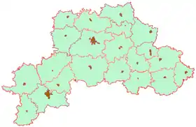
The twenty-one raions (districts) of the Mogilev Region are:
Cities and towns
Population of cities and towns in Mogilev Region
| English | Belarusian | Russian | Łacinka | Pop. |
|---|---|---|---|---|
| Mogilev | Belarusian: Магілёў | Russian: Могилёв | Łacinka: Mahiloŭ | 365,100 |
| Babruysk | Belarusian: Бабруйск | Russian: Бобруйск | 220,800 | |
| Asipovichy | Belarusian: Асiповiчы | Russian: Осипо́вичи | Łacinka: Asipovičy | 34,700 |
| Horki | Belarusian: Горкі | 34,000 | ||
| Krychaw | Belarusian: Крычаў | Łacinka: Kryčaŭ | 28,200 | |
| Bykhaw | Belarusian: Бы́хаў | Russian: Бы́хов | 17,300 | |
| Kastsyukovichy | Russian: Костюковичи | 16,100 | ||
| Klimavichy | Belarusian: Клiмавiчы | Russian: Климовичи | Łacinka: Klimavičy | 16,000 |
| Shklow | Belarusian: Шклоў | Russian: Шклов | Łacinka: Škłoŭ | 15,900 |
| Mstsislaw or Amstsislaw | Belarusian: Мсці́слаў, Амсьці́слаў, Мсьці́слаў | Russian: Мстиславль | Łacinka: Amścisłaŭ | 11,700 |
| Chavusy | Belarusian: Чавусы | Russian: Чаусы | Łacinka: Čavusy | 10,800 |
| Cherykaw | Russian: Чериков | 8,400 | ||
| Slawharad | Belarusian: Слаўгарод | Russian: Славгород | 8,300 | |
| Klichaw | Belarusian: Клічаў | Belarusian: Кличев | Łacinka: Klyčaŭ | 7,500 |
See also
References
- "Могилевский облсовет утвердил в должности председателя облисполкома Леонида Зайца". www.belta.by (in Russian). 2019-04-03. Retrieved 2019-12-06.
- "Sub-national HDI - Area Database - Global Data Lab". hdi.globaldatalab.org. Retrieved 2018-09-13.
- "Main Geographic Characteristics of the Republic of Belarus. Territory and population density of Belarus by region as of January 1, 2011". Land of Ancestors. The Scientific and Production State Republican Unitary Enterprise “National Cadastre Agency” of the State Property Committee of the Republic of Belarus. 2011. Archived from the original on 27 September 2013. Retrieved 24 September 2013.
- "Main Geographic Characteristics of the Republic of Belarus". Land of Ancestors. The Scientific and Production State Republican Unitary Enterprise “National Cadastre Agency” of the State Property Committee of the Republic of Belarus. 2011. Archived from the original on 21 September 2013. Retrieved 20 September 2013.
- Ministry of Sports and Tourism of the Republic of Belarus. (2011). "Number of organizations engaged in tourist activities in 2010 in Belarus". Land of Ancestors. National Statistical Committee of the Republic of Belarus. Archived from the original on 13 October 2013. Retrieved 10 October 2013.
- Ministry of Sports and Tourism of the Republic of Belarus. (2011). "Number of organizations engaged in tourist activities in Belarus by region". Land of Ancestors. National Statistical Committee of the Republic of Belarus. Archived from the original on 13 October 2013. Retrieved 10 October 2013.
- "Arrivals of organized tourists to the Republic of Belarus by region". Land of Ancestors. National Statistical Committee of the Republic of Belarus. 2011. Retrieved 10 October 2013.
External links
| Wikimedia Commons has media related to Mahilioŭ Region. |
- (in Russian and English) Mogilev Regional Executive Committee
| Districts (raiony) | | |
|---|---|---|
| Cities and towns | ||
| Authority control |
|---|