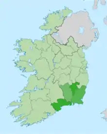
South-East Region, Ireland
The Ireland South East Region (coded IE052)[1] is a NUTS Level III statistical region of Ireland. The region comprises the counties of Waterford, Carlow, Kilkenny and Wexford. Waterford City is the regional capital.[2] The South-East region spans 7,198 km2, 10.2% of the total area of the state and according to the 2016 census had a population of 422,062.
History and geography
Ireland South East has a diverse mix of history – key towns and cities such as Waterford and Wexford have Viking origins, while Kilkenny city grew around a Norman merchant town. In terms of landscape and geography, Ireland South East is home to Europe's longest beaches, a number of mountain ranges (such as the Comeraghs, the Blackstairs and the Galtees) and rivers (such as the Nore, the Suir and the Barrow). It also Ireland's sunniest region and is affectionately known as the "Sunny South East".
Ireland South East is home to over 16,000 students, as the region includes Waterford Institute of Technology and Institute of Technology, Carlow. It is also home to global company brand names such as Glanbia; Bausch and Lomb; Red Hat; Zurich; Burnside Engineering; and Cartoon Saloon.
The region consistently scores highly on all quality of life metrics. It is known for the diversity and quantity of its festivals such as the Wexford Opera Festival, the Borris House Festival of Literature and Ideas, the Kilkenny Arts Festival and the Spraoi festival.
The region's economy is also strengthened by its good quality transport and economic infrastructure – including 2 international ports (Rosslare Europort); Waterford airport; a modern motorway network; and close proximity to Dublin.
Economy
The Ireland South East region has grown steadily over the past decade and has strong economic clusters in Engineering, Life Sciences, Financial Services, ICT, Agri-Food and the Creative sectors. Eurostat data shows the region as being the 6th fastest growing region in the EU in terms of job creation (2012–2017) and the 7th fastest growing region in terms of Gross Value Added (GVA) per person.
Ireland South East represents a place of opportunity for business, careers, investment, and tourism. A qualitative analysis of the company and infrastructural activity in the region also shows continuing positivity, with new job announcements, new investments, and major infrastructural projects underway. The region continues to score well on affordability and quality of life metrics making it an attractive place for talent and investment.
Regional GDP in 2017 was given as €15,513m, with income per person standing at 90.5% of the State average. The 2019 unemployment rate for the region stood at 8.1%.[3]
Tourism in the region is aided by its rich natural, historic and archaeological sites, which attract over 1 million people annually.[2]
Demography
According to the 2016 census, the region had a population of 422,062 which constitutes 8.86% of the national population. Its population density was 58.6 persons per km2. The population of the regional capital, Waterford, was 53,504.[2]
The main urban centres within the region each exceed 17,000 in terms of population with an evenly distributed network of second and third-tier towns.[2] This is also supplemented by a strong rural settlement initiative.[2]
Major settlements
A list of the ten largest settlements in the South-East region. County capitals are included and are shown in bold.
| Rank | Urban Centres | County | Population (2016 census) |
|---|---|---|---|
| 1 | Waterford | Waterford | 53,504 |
| 2 | Kilkenny | Kilkenny | 26,512 |
| 3 | Carlow | Carlow | 24,272 |
| 4 | Wexford | Wexford | 20,188 |
| 5 | Enniscorthy | Wexford | 11,381 |
| 6 | Tramore | Waterford | 10,381 |
| 7 | Gorey | Wexford | 10,366 |
| 8 | Dungarvan | Waterford | 9,227 |
| 9 | New Ross | Wexford | 8,040 |
| 10 | Tullow | Carlow | 4,673 |
Current Regional Authority
A number of local authority changes were made by the Irish government in June 2014, however these were not reflected in the NUTS 3 statistical units until June 2018, when appropriate updates were made following the implementation of Commission Regulation (EU) 2016/2066. North Tipperary County Council and South Tipperary County Council were unified into a single local authority for the county in 2014, however Tipperary remained divided between two NUTS 3 regions for statistical purposes. In June 2018 Tipperary was transferred in its entirety to the Mid-West Region.
Additionally, Waterford City Council was merged with Waterford County Council in 2014, however this too was not reflected at NUTS 3 level until 2018. Therefore the number of local authorities in the South-East Region has been reduced from 6 to 4. Prior to the change, South Tipperary comprised 23.8% of the South-East's land area and 19.1% of its population, making it the region's second largest county by area, and second smallest county by population.
The local authorities in the South-East Region are as follows:
- Carlow County Council
- Kilkenny County Council
- Waterford City and County Council
- Wexford County Council
Since the 2014 reforms, NUTS Level III regions have had no administrative role. The elected representatives of these councils instead convene at the Southern Regional Assembly for planning and local government purposes.
References
- "Revision to the Irish NUTS2 and NUTS3 regions". cso.ie.
- "iro.ie". www.iro.ie. Archived from the original on July 19, 2011.