County Dublin
County Dublin (Irish: Contae Bhaile Átha Cliath[2] or Contae Átha Cliath) is one of the thirty-two traditional counties of Ireland. Prior to 1994 it was also an administrative county covering the whole county outside of Dublin City Council. In 1994, as part of a reorganisation of local government within Dublin the boundaries of Dublin City were redrawn, Dublin County Council was abolished and three new administrative county councils were established: Dún Laoghaire–Rathdown, Fingal and South Dublin.
County Dublin
Contae Bhaile Átha Cliath | |
|---|---|
 Coat of arms | |
| Motto(s): Beart do réir ár mbriathar (Irish) "Action to match our speech" | |
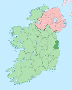 County Dublin shown darker on the green of Ireland with Northern Ireland in pink | |
| Country | Ireland |
| EU Parliament | Dublin |
| Province | Leinster |
| Established | 1190s[1] |
| County town | Dublin |
| Area | |
| • Total | 922 km2 (356 sq mi) |
| Area rank | 30th |
| Highest elevation (Kippure) | 757 m (2,484 ft) |
| Population (2016) | 1,345,402 |
| • Rank | 1st |
| • Density | 1,459/km2 (3,780/sq mi) |
| Demonym(s) | Dubliner Dub |
| Time zone | UTC±0 (GMT) |
| • Summer (DST) | UTC+1 (IST) |
| Eircode routing keys | D01–D18, D6W, D20, D22, D24, A41, A42, A45, A94, A96, K34, K45, K67, K78 |
| Telephone area codes | 01 |
| Vehicle index mark code | D |
While it is no longer used as an administrative division for local government, it retains a strong identity in popular culture. There still exists a sheriff appointed for County Dublin.[3] Although Constituency Commissions are must avoid breaching county boundaries when delineating Dáil constituencies, the three new counties in Dublin are excepted.[4] It is in the province of Leinster, and is named after the city of Dublin, the capital city of Ireland. County Dublin was one of the first parts of Ireland to be shired by John, King of England following the Norman invasion of Ireland.
According to the 2016 census, the total population of County Dublin was 1,345,402, approximately 27% of the Republic of Ireland's population.[5] The county is a NUTS 3 region,[6] and is part of the NUTS 2 region of Eastern and Midland.[7]
Local government and politics
Local authorities
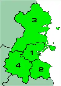
There are four local authorities whose remit collectively encompasses the geographic area of the county and city of Dublin. These are Dublin City Council, South Dublin County Council, Dún Laoghaire–Rathdown County Council and Fingal County Council.
Prior to the enactment of the Local Government (Dublin) Act 1993, the county was a unified whole even though it was administered by two local authorities – Dublin County Council and Dublin Corporation. Since the enactment of the Local Government Act 2001 in particular, the geographic area of the county has been divided between three entities at the level of "county" and a further entity at the level of "city". They rank equally as first level local administrative units of the NUTS 3 Dublin Region for Eurostat purposes. There are 34 LAU 1 entities in the Republic of Ireland. Each local authority is responsible for certain local services such as sanitation, planning and development, libraries, the collection of motor taxation, local roads and social housing.
Dublin County Council (which did not include the county borough of Dublin) was abolished in 1994 and the area divided among the administrative counties of Dún Laoghaire–Rathdown, Fingal and South Dublin each with its county seat. To these areas may be added the area of Dublin city which collectively comprise the Dublin Region[8] (Réigiúin Átha Cliath) and come under the remit of the Dublin Regional Authority.
The area lost its administrative county status in 1994, with Section 9 Part 1(a) of the Local Government (Dublin) Act, 1993 stating that "the county shall cease to exist."[9][10] In discussing the legislation to dissolve Dublin County Council, Avril Doyle TD said, "The Bill before us today effectively abolishes County Dublin, and as one born and bred in these parts of Ireland I find it rather strange that we in this House are abolishing County Dublin. I am not sure whether Dubliners realise that that is what we are about today, but in effect that is the case."[11]
The county is part of the Dublin constituency for the purposes of European elections. For elections to Dáil Éireann, the area of the county is currently (2016) divided into eleven constituencies: Dublin Bay North, Dublin Bay South, Dublin Central, Dublin Fingal, Dublin Mid-West, Dublin North-West, Dublin Rathdown, Dublin South-Central, Dublin South-West, Dublin West, and Dún Laoghaire. Together they return 45 deputies (TDs) to the Dáil.
| Dublin City | Dún Laoghaire–Rathdown | Fingal | South Dublin | |
|---|---|---|---|---|
| Coat of Arms |  |
 |
 |
 |
| Motto | Obedientia Civium Urbis Felicitas (Latin) "An Obedient Citizenry Produces a Happy City" |
Ó Chuan go Sliabh (Irish) "From Harbour to Mountain" |
Flúirse Talaimh is Mara (Irish) "Abundance of Land and Sea" |
Ag Seo Ár gCúram (Irish) "This We Hold in Trust" |
| County town | Dublin | Dún Laoghaire | Swords | Tallaght |
| Dáil Éireann | Dublin Central Dublin Bay North Dublin North-West Dublin South-Central Dublin Bay South |
Dún Laoghaire Dublin Rathdown |
Dublin Bay North Dublin Fingal Dublin North-West Dublin West |
Dublin Mid-West Dublin South-Central Dublin South-West |
| Local Authority | Dublin City Council | Dún Laoghaire–Rathdown County Council |
Fingal County Council | South Dublin County Council |
| Council Seats | 63 | 40 | 40 | 40 |
| Chairperson | Hazel Chu (Lord Mayor) |
Una Power (Cathaoirleach) |
David Healy (Mayor) |
Ed O'Brien (Mayor) |
| Population (2016) | 554,554 | 218,018 | 296,020 | 278,767 |
| Increase since 2011 | ||||
| Area | 118 km2 (46 sq mi)[12] | 126 km2 (49 sq mi)[13] | 456 km2 (176 sq mi)[14] | 223 km2 (86 sq mi)[15] |
| Density | 4,811/km2 | 1,707/km2 | 652/km2 | 1,252/km2 |
| Highest elevation | N/A | Two Rock 536 m (1,759 ft) |
Knockbrack 176 m (577 ft) |
Kippure 757 m (2,484 ft) |
| Website | www |
www |
www |
www |

Despite the legal status of the Dublin Region, the term "County Dublin" is still in common usage. Many organisations and sporting teams continue to organise on a "County Dublin" or "Dublin Region" basis. The area formerly known as "County Dublin" is now defined in legislation solely as the "Dublin Region" under the Local Government Act, 1991 (Regional Authorities) (Establishment) Order, 1993,[8] and this is the terminology officially used by the four Dublin administrative councils in press releases concerning the former county area. The term Greater Dublin Area, which might consist of some or all of the Dublin Region along with counties of Kildare, Meath and Wicklow, has no legal standing.
Dublin Region
The Dublin Region is a NUTS Level III region of Ireland. The region is one of eight regions of the Republic of Ireland for the purposes of Eurostat statistics. Its NUTS code is IE061.[16] It is co-extensive with the old county. The regional capital is Dublin City which is also the national capital.[17]
The latest Ordnance Survey Ireland "Discovery Series" (Third Edition 2005) 1:50,000 map of the Dublin Region, Sheet 50, shows the boundaries of the city and three surrounding counties of the region. Extremities of the Dublin Region, in the north and south of the region, appear in other sheets of the series, 43 and 56 respectively.
Subdivisions
Baronies
.png.webp)
There are nine historic baronies in the county.[18] While baronies continue to be officially defined units, they are no longer used for many administrative purposes. The last boundary change of a barony in Dublin was in 1842, when the barony of Balrothery was divided into Balrothery East and Balrothery West. Their official status is illustrated by Placenames Orders made since 2003, where official Irish names of baronies are listed under "Administrative units". The largest barony in Dublin is Uppercross, at 37,307 acres (151 km2), and the smallest barony is Dublin, at 1,693 acres (6.9 km2).
- Balrothery East (Baile an Ridire Thoir)
- Balrothery West (Baile an Ridire Thiar)
- Castleknock (Caisleán Cnucha)
- Coolock (An Chúlóg)
- Dublin (Bhaile Átha Cliath)
- Dublin City (Cathair Baile Átha Cliath)
- Nethercross (An Chrois Íochtarach)
- Newcastle (An Caisleán Nua)
- Rathdown (Ráth an Dúin)
- Uppercross (An Chrois Uachtarach)
Townlands
Townlands are the smallest officially defined geographical divisions in Ireland. There are 1,090 townlands in Dublin, of which 88 are historic town boundaries. These town boundaries are registered as their own townlands and are much larger than rural townlands. The smallest rural townlands in Dublin are just 1 acre in size, most of which are offshore islands (Clare Rock Island, Lamb Island, Maiden Rock, Muglins, Thulla Island). The largest rural townland in Dublin is 2,797 acres (Caastlekelly). The average size of a townland in the county (excluding towns) is 205 acres.
Geography
.jpg.webp)


Dublin is the third smallest of Ireland's 32 counties by area, and the largest in terms of population. It is the third-smallest of Leinster's 12 counties in size and the largest by population. Dublin shares a border with three counties - Meath to the north and west, Kildare to the west and Wicklow to the south. To the east, Dublin has an Irish Sea coastline which stretches for roughly 100 kilometres (62 mi).[19][20]
Dublin is a topographically varied region. The city centre is generally very low-lying, and many areas of coastal Dublin are at or near sea-level. In the south of the county, the topography rises steeply from sea-level at the coast to over 500 metres (1,600 ft) in just a few kilometres. This natural barrier has resulted in densely populated coastal settlements in Dún Laoghaire–Rathdown and westward urban sprawl in South Dublin. In contrast, Fingal is generally rural in nature and much less densely populated than the rest of the county. Consequently, Fingal is significantly larger than the other three local authorities and covers about 49.5% of County Dublin's land area. Fingal is also perhaps the flattest region in Ireland, with the low-lying Naul Hills rising to a maximum height of just 176 metres (577 ft).[21]
Dublin is bounded to the south by the Wicklow Mountains. Where the mountains extend into County Dublin, they are known locally as the Dublin Mountains (Sléibhte Bhaile Átha Cliath). Kippure, on the Dublin-Wicklow border, is the county's highest mountain, at 757 metres (2,484 ft) above sea level. The mountains are a popular amenity area, with Two Rock, Three Rock, Tibradden and Montpelier Hill being among the most heavily foot-falled hiking destinations in Ireland. Forest cover extends to over 6,000 hectares (15,000 acres) within the county, nearly all of which is located in the Dublin Mountains. With just 6.5% of Dublin under forest, it is the 6th least forested county in Ireland.[22]
Much of the county is drained by the River Liffey and two of its main tributaries, the River Tolka in north Dublin and the River Dodder in south Dublin. The Liffey, at 125 kilometres (78 mi) in length, is the 8th longest river in Ireland, and rises near Tonduff in County Wicklow, reaching the Irish Sea at the Dublin Docklands. The Liffey cuts through the centre of Dublin city, and the resultant Northside-Southside divide is an often used social, economic and linguistic distinction. In terms of biodiversity, the estuarine and coastal areas of the county are home to a wealth ecologically important areas. County Dublin contains 11 EU-designated Special Areas of Conservation (SACs) and 11 Special Protection Areas (SPAs).[23]
The bedrock geology of Dublin consists primarily of Lower Carboniferous limestone, which underlies about two thirds of the entire county, stretching from Skerries to Booterstown. During the Lower Carboniferous (ca. 340 Mya), the area was part of a warm tropical sea inhabited by an abundance of corals, crinoids and brachiopods. The oldest rocks in Dublin are the Cambrian shales located on Howth Head, which were laid down ca. 500 Mya. Disruption following the closure of the Iapetus Ocean approximately 400 Mya resulted in the formation of granite.[24] This is now exposed at the surface from the Dublin Mountains to the coastal areas of Dún Laoghaire. 19th-century Lead extraction and smelting at the Ballycorus Leadmines caused widespread lead poisoning, and the area was once nicknamed "Death Valley".[25]
Prominent geographic features
- Dublin Bay
- Dublin Mountains
- Glenasmole Valley
- Howth Head
- Killiney Hill
- Montpelier Hill
- Phoenix Park
- Rivers Liffey, Dodder and Tolka
- Rogerstown Estuary
- Ticknock Forest
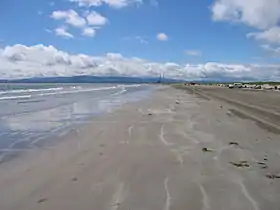
- Velvet Strand
Climate


.jpg.webp)
Dublin is in a maritime temperate oceanic region according to Köppen climate classification. Its climate is characterised by cool winters, mild humid summers, and a lack of temperature extremes. Met Éireann have a number of weather stations in the county, with its two primary stations at Dublin Airport and Casement Aerodrome.
Annual temperatures typically fall within a narrow range. In Merrion Square, the coldest month is February, with an average minimum temperature of 2.7 °C (36.9 °F), and the hottest month is July, with an average maximum temperature of 20.2 °C (68.4 °F). Due to the urban heat island effect, Dublin city has the warmest summertime nights in Ireland. The average minimum temperature at Merrion Square in July is 13.5 °C (56.3 °F), similar to London and Berlin.[26] At Dublin Airport, the driest month is February with 48.8 mm (2 in) of rainfall, and the wettest month is November, with 79.0 mm (3 in) of rain on average.
As the prevailing wind direction in Ireland is from the south and west, the Wicklow Mountains create a rain shadow over much of the county. Dublin's sheltered location makes it the driest place in Ireland, receiving only about half the rainfall of the west coast. Ringsend in the south of Dublin city records the lowest rainfall in the country, with an average annual precipitation of 683 mm (27 in). The wettest area of the county is the Glenasmole Valley, which receives 1,159 mm (46 in) of rainfall per year. As a temperate coastal county, snow is relatively uncommon in lowland areas; however, Dublin is particularly vulnerable to heavy snowfall on rare occasions where cold, dry easterly winds dominate during the winter.[27]
During the late summer and early autumn, Dublin can experience Atlantic storms, which bring strong winds and torrential rain to Ireland. Dublin was the county worst-affected by Hurricane Charley in 1986. It caused severe flooding, especially along the River Dodder, and is reputed to be the worst flood event in Dublin's history. Rainfall records were shattered across the county. Kippure recorded 280 mm (11 in) of rain over a 24-hour period, the greatest daily rainfall total ever recorded in Ireland. The government allocated IR£6,449,000 (equivalent to US$20.5 million in 2020) to repair the damage wrought by Charley.[28] The two reservoirs at Bohernabreena in the Dublin Mountains were upgraded in 2006 after a study into the impact of Hurricane Charley concluded that a slightly larger storm would have caused the reservoir dams to burst, which would have resulted in catastrophic damage and significant loss of life.
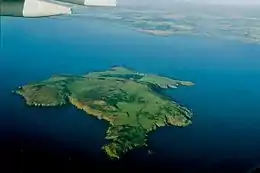
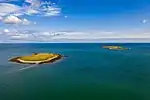
Offshore Islands
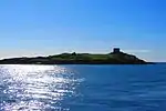
In contrast with the Atlantic Coast, the east coast of Ireland has relatively few islands. County Dublin has the highest concentration of islands on the Irish east coast. Colt Island, St. Patrick's Island and Shenick Island are clustered off the coast of Skerries, and are collectively known as the "Skerries Islands Natural Heritage Area". Further out lies Rockabill, which is Dublin's most isolated island, at about 6 kilometres (3.7 mi) offshore. Lambay Island, at 250 hectares (620 acres), is the largest island off Ireland's east coast and the easternmost point of County Dublin. Lambay supports one of the largest seabird colonies in Ireland and, curiously, also supports a population of non-native Red-necked wallabies.[29] To the south of Lambay lies a smaller island known as Ireland's Eye - the result of a mistranslation of the island's Irish name by invading Vikings.
Bull Island is a man-made island lying roughly parallel to the shoreline which began to form following the construction of the Bull Wall in 1825. The island is still growing and is currently 5 kilometres (3.1 mi) long and 0.8 kilometres (0.50 mi) wide. In 1981, North Bull Island (Oileán an Tairbh Thuaidh) was designated as a UNESCO biosphere.[30]
- Islands of County Dublin
.jpg.webp)

Demographics
Population
| Year | Pop. | ±% |
|---|---|---|
| 1500 | 14,755 | — |
| 1510 | 23,471 | +59.1% |
| 1550 | 21,678 | −7.6% |
| 1580 | 20,345 | −6.1% |
| 1585 | 20,224 | −0.6% |
| 1600 | 24,556 | +21.4% |
| 1610 | 12,567 | −48.8% |
| 1653 | 18,847 | +50.0% |
| 1659 | 21,827 | +15.8% |
| 1672 | 55,678 | +155.1% |
| 1680 | 101,414 | +82.1% |
| 1690 | 145,219 | +43.2% |
| 1700 | 161,234 | +11.0% |
| 1710 | 173,690 | +7.7% |
| 1720 | 205,111 | +18.1% |
| 1725 | 212,670 | +3.7% |
| 1735 | 209,785 | −1.4% |
| 1745 | 217,666 | +3.8% |
| 1755 | 235,799 | +8.3% |
| 1765 | 244,103 | +3.5% |
| 1771 | 255,297 | +4.6% |
| 1775 | 271,475 | +6.3% |
| 1781 | 285,799 | +5.3% |
| 1788 | 291,433 | +2.0% |
| 1790 | 297,644 | +2.1% |
| 1801 | 300,345 | +0.9% |
| 1811 | 305,766 | +1.8% |
| 1813 | 311,798 | +2.0% |
| 1816 | 318,760 | +2.2% |
| 1821 | 335,892 | +5.4% |
| 1831 | 380,167 | +13.2% |
| 1841 | 372,773 | −1.9% |
| 1851 | 405,147 | +8.7% |
| 1861 | 410,252 | +1.3% |
| 1871 | 405,262 | −1.2% |
| 1881 | 418,910 | +3.4% |
| 1891 | 419,216 | +0.1% |
| 1901 | 448,206 | +6.9% |
| 1911 | 477,196 | +6.5% |
| 1926 | 505,654 | +6.0% |
| 1936 | 586,925 | +16.1% |
| 1946 | 636,193 | +8.4% |
| 1951 | 693,022 | +8.9% |
| 1956 | 705,781 | +1.8% |
| 1961 | 718,332 | +1.8% |
| 1966 | 795,047 | +10.7% |
| 1971 | 852,219 | +7.2% |
| 1979 | 983,683 | +15.4% |
| 1981 | 1,003,164 | +2.0% |
| 1986 | 1,021,449 | +1.8% |
| 1991 | 1,025,304 | +0.4% |
| 1996 | 1,058,264 | +3.2% |
| 2002 | 1,122,821 | +6.1% |
| 2006 | 1,187,176 | +5.7% |
| 2011 | 1,270,603 | +7.0% |
| 2016 | 1,345,402 | +5.9% |
| [31][32][33][34][35][36] | ||
.jpeg.webp)
As of the 2016 Census, the population of Dublin was 1,345,402, a 5.7% increase since the 2011 Census. The county's population first surpassed 1 million in 1981, and is projected to reach between 1.5 million and 1.7 million by 2031.[37]
Dublin is Ireland's most populous county, a position it has held since the 1901 Census, when it overtook County Cork. As of 2016, Dublin has over twice the population of Antrim and two and a half times the population of Cork. Approximately 20.5% of Ireland's population lives within County Dublin (27% if only the Republic of Ireland is counted). Additionally, Dublin has more people than the combined populations of Ireland's 16 smallest counties.
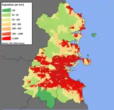
With an area of just 922 km2 (356 sq mi), Dublin is by far the most densely populated county in Ireland. The population density of the county is 1,459 people per square kilometre - nearly 7 times higher than Ireland's second most densely populated county, County Down in Northern Ireland.
During the Celtic Tiger period, a large number of Dublin natives (Dubliners) moved to the rapidly expanding commuter towns in the adjoining counties. As of 2016, approximately 25.8% (305,996) of Dubliners were living outside of County Dublin. People born within Dublin comprise 28% of the population of Meath, 31% of Kildare and 35% of Wicklow. There are 880,457 Dublin natives living within the county, accounting for 66.8% of the population. People born in other Irish counties living within Dublin account for roughly 12.4% of the population.[38]
Between 2011 and 2016, international migration produced a net increase of 25,261 people. Dublin has the highest proportion of international residents of any county in Ireland, with around 21% of the county's population being born outside of the Republic of Ireland.[39]
As of the 2016 Census, 6.8 percent of the county's population was reported as younger than 5 years old, 25.2 percent were between 5 and 25, 55.8 percent were between 25 and 65, and 12.2 percent of the population was older than 65. Of this latter group, 18,276 people (1.4 percent) were over the age of 80. The population was evenly split between females (50.14 percent) and males (49.86 percent).
In 2019, there were 17,682 births within the county, and the average age of a first time mother was 31.[40]
Migration
| Main immigrant groups, 2016[41] | |
| Country of birth | Population |
|---|---|
| 55,391 | |
| 33,751 | |
| 18,119 | |
| 11,572 | |
| 9,865 | |
| 9,013 | |
| 8,485 | |
| 8,223 | |
| 7,313 | |
| 7,290 | |
| 6,770 | |
| *Includes Hong Kong SAR | |
Just over one fifth (20.8 percent) of County Dublin's population was born outside of the Republic of Ireland. In 2016, Fingal had the highest percentage of non-nationals in Dublin (23.2 percent), and South Dublin had the lowest (17.5 percent). The immigrant population of Dublin is mainly from other European countries, however there are also substantial numbers of Indians, Brazilians, Americans and East Asians living in the county. Immigrants from other European Union member states comprise 10.4 percent of Dublin's population, and those from the United Kingdom a further 5.3 percent.[42]
The largest sources of foreign-born residents in Dublin are the United Kingdom and Poland, although the growth of these two groups has slowed in recent years. Prior to the 2000s, the UK was historically the largest single source of non-nationals living in Dublin. Of those born in the UK, 76.3 percent were born in Britain, and the remaining 23.7 percent were born in Northern Ireland. Between 2011 and 2016, the number of UK-born residents living in Dublin declined by 1.8 percent.
There is a large difference between the number of people living in Dublin who were born in the UK (55,391) and those who stated that they were UK citizens in the 2016 census (19,196). This discrepancy can arise for a variety of factors, such as people born in Northern Ireland claiming Irish citizenship rather than UK citizenship, Irish people born in the UK who now live in Dublin, British people who have become natural citizens, and foreign residents of Dublin who were born in the UK but are not UK citizens. Depending on an individual's responses in the census, all of these examples could result in the country of birth being registered by the CSO as the United Kingdom, but nationality being registered as Irish or a third country.
Following its accession to the EU, the Polish quickly became the fastest growing immigrant community in Dublin. Just 188 Poles had applied for Irish work permits in 1999. By 2006 this number had grown to 93,787.[43] After the 2008 Irish economic downturn, as many as 3,000 Poles left Ireland each month. Despite this, Poles still account for roughly one quarter of Dublin's EU foreign residents, and are the largest non-national group in the county, as well as the second largest foreign-born group.
As of 2016, the fastest growing major immigrant group in Dublin was Romanians. Despite being an EU member since 2007, Ireland had restrictions on the number of Romanians who could emigrate to the country until 2012. The removal of the restrictions was followed by a significant increase in the number of Romanians living in Dublin. The five year period from 2011 to 2016 saw a 67.7 percent increase in the number of Romanians living in Dublin, who are now the county's third largest foreign national group. County Dublin is home to around 58 percent of Ireland's Romanian community.
Outside of Europe, Brazil and India are the largest and fastest growing sources of foreign residents in Dublin. The number of Brazilians living in Dublin increased by 48.5 percent between 2011 and 2016, primarily driven by Ireland's participation in the Brazilian government's Ciência sem Fronteiras programme, which sees thousands of Brazilian students come to study in Ireland each year, many of whom remain in the country afterwards. Dublin's Indian community grew by 15.1 percent from 2011-2016, and Indians are now the fourth largest migrant group in the county. The influx of Indians is primarily driven by multinational tech companies such as Microsoft, Google and Facebook who have located their European headquarters within the county, in areas such as the Silicon Docks and Sandyford. In August 2020, the first dedicated Hindu temple in Ireland was built in Walkinstown.[44]
Ethnicity
According to the Central Statistics Office, in 2016 the population of County Dublin self-identified as:
- 87.6% White (75.5% White Irish, 11.7% Other White Background, 0.5% Irish Traveler)
- 3.8% Asian
- 2.3% Mixed background
- 2.2% Black
- 4.1% Not Stated
By ethnicity, in 2016 the population was 87.6% white. Those who identified as White Irish constituted 75.5% of the county's population, and Irish Travelers comprised a further 0.5%. Caucasians who did not identify as ethnically Irish accounted for 11.7% of the population.
In terms of total numbers, Dublin has the largest non-white population Ireland, with an estimated 109,732 residents, accounting for 8.3% of the county's population. Nearly half (44.7 percent) of Ireland's black residents live within the county. In terms of percentage of population, Fingal has the highest percentage of both black (3.9 percent) and non-white (10.1 percent) residents of any local authority in Ireland. Conversely, Dún Laoghaire–Rathdown in the south of the county has one of Ireland's lowest percentages of black residents, with only 0.67% of the population identifying as black in 2016. Additionally, 42.8% of Ireland's multiracial population lives within County Dublin.[45]
Religion
.jpg.webp)
The largest religious denomination by both number of adherents and as a percentage of Dublin's population in 2016 was the Roman Catholic Church, with 68.9 percent. All other Christian denominations including Church of Ireland, Eastern Orthodox, Presbyterian and Methodist accounted for 7.0 percent of Dublin's population. Together, all denominations of Christianity accounted for 75.9 percent of the county's population. According to the 2016 census, Dublin city is the least religious local authority in Ireland, with 18.1 percent of the population declaring themselves non-religious, followed closely by Dún Laoghaire–Rathdown and Galway city (17.1 percent). In the county as a whole, those unaffiliated with any religion represented 14.4 percent of the population, which is the largest percentage of non-religious people of any county in Ireland.
Of the non-Christian religions, Islam is the largest in terms of number of adherents, with Muslims accounting for 2.2% of the population. After Islam, the largest non-Christian religions in 2016 were Hinduism (0.62 percent), Buddhism (0.32 percent) and Judaism (0.11 percent). While small in percentage terms, County Dublin contains over half of Ireland's Hindu (58.4 percent), Jewish (56.3 percent) and Eastern Orthodox (52.1%) residents, and just under half of its Islamic (47.3 percent) and Buddhist (44.0 percent) residents.[46]
Dublin and its hinterland has been a Christian diocese since 1028. For centuries, the Primacy of Ireland was disputed between Dublin, the social and political capital of Ireland, and Armagh, site of Saint Patrick's main church, which was founded in 445 AD. In 1353 the dispute was settled by Pope Innocent VI, who proclaimed that the Archbishop of Dublin was Primate of Ireland, while the Archbishop of Armagh was titled Primate of All Ireland. These two distinct titles were replicated in the Church of Ireland following the Reformation. Historically, County Dublin was the epicentre of Protestantism in Ireland outside of Ulster. Records from the 1891 census show that the county was 21.4 percent Protestant towards the end of the 19th century. By the 1911 census this had gradually declined to around 20% due to poor economic conditions, as Dublin Protestants moved to industrial Belfast. Following the War of Independence (1919-1921), Dublin's Protestant community went into a steady decline, falling to 8.5 percent of the population by 1936.[47]
Between the 2011 and 2016 census, the fastest growing religions in Dublin were Evangelicalism (111.7 percent), Eastern Orthodox (41.0 percent), Hinduism (30.1 percent) and Islam (17.7 percent), while the most rapidly declining religions were Methodist/Wesleyan (-9.6 percent), Catholicism (-5.5 percent) and Anglicanism (-4.7 percent).
Dublin city
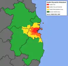
The boundaries of Dublin City Council comprise the urban core of the city, often referred to as "Dublin city centre", an area of 117.8 square kilometres. This encompasses the central suburbs of the city, extending as far south as Terenure and Donnybrook; as far north as Ballymun and Donaghmede; and as far west as Ballyfermot. As of 2016, there were 554,554 people living within Dublin city centre. However, as the continuous built-up area extends beyond the city boundaries, the term "Dublin city and suburbs" is commonly employed when referring to the actual extent of Dublin.
Dublin city and suburbs
Dublin city and suburbs is a CSO-designated urban area which includes the densely populated contiguous built-up area which surrounds Dublin city centre. It encompasses 317.5 square kilometres and contains approximately 87% of County Dublin's population (1,173,179 people) as of the 2016 census.
Dublin Metropolitan Area
As the city proper does not extend beyond Dublin Airport, the towns of "North County Dublin" such as Swords, Lusk, Rush and Malahide are not considered part of the city, and are recorded by the CSO as separate settlements. Under Ireland's National Planning Framework, these towns are considered part of the Dublin Metropolitan Area (DMA). The DMA also includes towns outside of the county, such as Naas, Leixlip and Maynooth in County Kildare, and Bray and Greystones in County Wicklow, but does not include Balbriggan or Skerries, which are located in the far north of County Dublin.[48]
Greater Dublin Area
The Greater Dublin Area (GDA) is a commonly used planning jurisdiction which extends to the wider network of commuter towns that are economically connected to Dublin city. The GDA consists of County Dublin and its three neighboring counties, Meath, Kildare and Wicklow. With a population of 1.9 million and an area of 6,986 square kilometres, it contains 40% of the population of the State, and covers 9.9% of its land area.
| Statistical Area | Population (2016) | Area (km2) | Local Authorities |
|---|---|---|---|
| Dublin City | 554,554 | 117.8 | Dublin |
| Dublin City and suburbs | 1,173,179 | 317.5 | Dublin, Fingal, South Dublin, Dún Laoghaire-Rathdown |
| County Dublin | 1,345,402 | 922 | Dublin, Fingal, South Dublin, Dún Laoghaire-Rathdown |
| Dublin Metropolitan Area | 1,400,000 | 1,000 | Dublin, Fingal, South Dublin, Dún Laoghaire-Rathdown, Meath, Kildare, Wicklow |
| Greater Dublin Area | 1,904,806 | 6,986 | Dublin, Fingal, South Dublin, Dún Laoghaire-Rathdown, Meath, Kildare, Wicklow |
Urban Areas
Under CSO classification, an "Urban Area" is a town with a population greater than 1,500. Dublin is the most urbanised county in Ireland, with 97.75% of its residents residing in urban areas as of 2016. Of Dublin's three non-city local authorities, Fingal has the highest proportion of people living in rural areas (7.9%), while Dún Laoghaire-Rathdown has the lowest (1.19%). The western suburbs of Dublin city such as Tallaght and Blanchardstown have experienced rapid growth in recent decades, and both areas have a population roughly equivalent to Galway city.
Media
.jpg.webp)
Local radio stations include 98FM, FM104, Dublin City FM, Q102, SPIN 1038, Sunshine 106.8, Raidió Na Life and Radio Nova.
Local newspapers include The Echo, and the Liffey Champion.
Most of the area can receive the five main UK television channels as well as the main Irish channels, along with Sky TV and Virgin Media Ireland cable television.
Transport
- Road: The major roads are the N2, N3, N4 and N7 national primary roads, and the M1, M11 and M50 motorways.
- Heavy rail: The InterCity and Commuter rail services (Iarnród Éireann).
- Light rail: The Luas tram system serving Dublin City and its southern and western suburbs.
- Rapid transit: The DART
- Port: Dublin Port and Dún Laoghaire Harbour.
- Air: Dublin Airport.
Economy
The economy of County Dublin was identified as being the powerhouse behind the Celtic Tiger, a period of strong economic growth of the state. This resulted in the economy of the county expanding by almost 100% between the early 1990s and 2007. This growth resulted from incoming high-value industries, such as financial services and software manufacturing, as well as low-skilled retail and domestic services, which caused a shift away from older manufacturing industry.[17] This change saw high unemployment in the 1980s and early 1990s which resulted in damage to the capital's social structure.[17]
According to CSO figures, the region had a GDP of €87.238 bn and a GDP per capita of €68,208 in 2014 (the second highest was Cork at €50,544 per capita).[50]
Separately, Eurostat figures for 2012 suggested the region then had a GDP of €72.384 bn and a GDP per capita of €57,200 – the highest on the island of Ireland (the second highest being Cork with €48,500).[51]
As of early 2017, the unemployment rate for the Dublin region was estimated at 6%.[52]
Transport
County Dublin is the main transport node of Ireland,[17] and contains one international airport, Dublin Airport. It is also served by two main seaports, Dún Laoghaire port and Dublin Port, which is just located outside of the city center. The two main train stations are Dublin Heuston and Dublin Connolly, both of which serve intercity trains.
Towns and suburbs
- Adamstown
- Artane
- Ashtown
- Balbriggan
- Baldoyle
- Balgriffin
- Ballinteer
- Ballsbridge
- Ballyboden
- Ballybrack
- Ballybough
- Ballyfermot
- Ballygall
- Ballymount
- Ballymun
- Ballyroan
- Balrothery
- Bayside
- Beaumont
- Belfield
- Blackrock
- Blanchardstown
- Bluebell
- Booterstown
- Brittas
- Broadstone
- Ballyboughal
- Cabinteely
- Cabra
- Carrickmines
- Castleknock
- Chapelizod
- Cherrywood
- Churchtown
- Citywest
- Clondalkin
- Clongriffin
- Clonsilla
- Clonskeagh
- Clontarf
- Coolmine
- Coolock
- Corduff
- Cornelscourt
- Crumlin
- Dalkey
- Damastown
- Darndale
- Dartry
- Deansgrange
- Dollymount
- Dolphin's Barn
- Donabate
- Donaghmede
- Donnybrook
- Donnycarney
- Drimnagh
- Drumcondra
- Dún Laoghaire
- Dundrum
- East Wall
- Edmondstown
- Fairview
- Finglas
- Firhouse
- Foxrock
- Garristown
- Glasnevin
- Glasthule
- Glencullen
- Glenageary
- Goatstown
- Grangegorman
- Harold's Cross
- Howth
- Inchicore
- Irishtown
- Islandbridge
- Jobstown
- Kill O' The Grange
- Kilbarrack
- Killester
- Killiney
- Kilmacud
- Kilmainham
- Kilnamanagh
- Kilternan
- Kimmage
- Kinsealy
- Knocklyon
- Leopardstown
- Loughlinstown
- Lucan
- Lusk
- Malahide
- Marino
- Milltown
- Monkstown
- Mount Merrion
- Mulhuddart
- Newcastle
- Naul
- Oldbawn
- Ongar
- Palmerstown
- Phibsborough
- Portmarnock
- Portobello
- Raheny
- Ranelagh
- Rathcoole
- Rathfarnham
- Rathgar
- Rathmichael
- Rathmines
- Rialto
- Ringsend
- Rush
- Saggart
- Sallynoggin
- Sandycove
- Sandyford
- Sandymount
- Santry
- Shankill
- Skerries
- Smithfield
- Stepaside
- Stillorgan
- Stoneybatter
- Sutton
- Swords
- Tallaght
- Templeogue
- Terenure
- The Coombe
- Tyrrelstown
- Walkinstown
- Whitechurch
- Whitehall
- Windy Arbour
See also
- For the baronial sub-divisions of the old county
- List of abbeys and priories in Ireland (County Dublin)
- List of mountains and hills of County Dublin
- List of rivers in County Dublin
- List of schools in County Dublin
- List of subdivisions of County Dublin
- List of townlands of County Dublin
- List of regions of Ireland
- Greater Dublin Area
References
- "'Geographical loyalty'? Counties, palatinates, boroughs and ridings". 6 March 2013.
- "Logainm.ie" (PDF).
- Nick, Callan (30 November 2018). "Government makes appointments to Sheriff posts". merrionstreet.ie (Press release). Retrieved 11 July 2019.; Hyland, Paul (5 August 2012). "Explainer: Who and what are Ireland's sheriffs?". TheJournal.ie. Retrieved 11 July 2019.; "Role of County Registrar". Courts Service of Ireland. Retrieved 11 July 2019.; Sheehan, Maeve (22 December 2013). "Good, bad and ugly side of being the city's sheriff". Sunday Independent. Retrieved 11 July 2019.
- "Electoral Act 1997 s.6(4)". electronic Irish Statute Book. Retrieved 12 January 2021.
- Population and Actual and Percentage Change 2011 to 2016 by Sex, Province County or City, CensusYear and Statistic, Central Statistics Office. Retrieved 16 Jul 2016
- Regulation (EC) No 1059/2003 of the European Parliament and of the Council of 26 May 2003 on the establishment of a common classification of territorial units for statistics (NUTS) (OJ L 154 21.6.2003, p. 1).
- "Eastern and Midland Regional Assembly". Eastern & Midland Regional Assembly. Retrieved 30 September 2016.
- "Local Government Act, 1991 (Regional Authorities) (Establishment) Order, 1993". Archived from the original on 11 February 2007. Retrieved 31 July 2009.
- Act of the Oireachtas: Local Government (Dublin) Act, 1993 (Section 9 Part 1(a))
- Local Government (Dublin) Act, 1993 Section 2 specifies: "the county", in relation to any time before the establishment day, means the administrative county of Dublin.
- Dáil Éireann: Parliamentary Debates (3 November 1993) Archived 19 March 2005 at the Wayback Machine
- "Dublin City Profile" (PDF). Maynooth University. Dublin City Development Board. 1 January 2002. Retrieved 6 November 2020.
- "Dún Laoghaire–Rathdown County Progile" (PDF). Maynooth University.
- "Fingal Climate Change Adaptation Plan" (PDF). Fingal County Council.
- "About Us - SDCC". South Dublin County Council.
- "Revision to the Irish NUTS2 and NUTS3 regions". cso.ie.
- "Home Page". Irish Regions European Office.
- Placenames Database of Ireland - Baronies.
- "Coastal Walks". Fingal County Council.
- "Bullock and Sandycove Harbours Draft Masterplan" (PDF). DLRCoCo.
- "Fingal County Council, 2002". Archived from the original on 22 July 2011. Retrieved 27 November 2009.
- "National Forestry Inventory, Third Cycle 2017" (PDF). DAFM.
- "Protected Sites in Ireland". NPWS.
- "Geology of County Dublin" (PDF). geoschol.
- Dún Laoghaire-Rathdown County Council, p. 10.
- "Climatological Information for Merrion Square, Ireland". European Climate Assessment & Dataset.
- "Temperature – Climate – Met Éireann – The Irish Meteorological Service Online". Met.ie. 2 January 1979. Retrieved 20 August 2010.
- Seanad Éireann (8 March 1990). "Storm and Flood Damage: Motion". Office of the Houses of the Oireachtas. Archived from the original on 7 June 2011. Retrieved 26 October 2008.
- "East coast - Knockbane (Hill), Lambay Island". MountainViews.ie. Retrieved 3 June 2020.
Height: 126m OS 1:50k Mapsheet: 43 Grid Reference: O31600 51000
- "North Bull Island". Ramsar Sites Information Service. Retrieved 25 April 2018.
- For 1653 and 1659 figures from Civil Survey Census of those years, Paper of Mr Hardinge to Royal Irish Academy 14 March 1865.
- "Census for post 1821 figures".
- "Histpop – The Online Historical Population Reports Website homepage". Archived from the original on 7 May 2016. Retrieved 4 December 2010.
- "Northern Ireland Census of Population". NISRA. Archived from the original on 17 February 2012. Retrieved 4 December 2010.
- Lee, JJ (1981). "On the accuracy of the Pre-famine Irish censuses". In Goldstrom, J. M.; Clarkson, L. A. (eds.). Irish Population, Economy, and Society: Essays in Honour of the Late K. H. Connell. Oxford, England: Clarendon Press.
- Mokyr, Joel; Ó Gráda, Cormac (November 1984). "New Developments in Irish Population History, 1700-1850" (PDF). The Economic History Review. 37 (4): 473–488. doi:10.1111/j.1468-0289.1984.tb00344.x. hdl:10197/1406.
- "Regional Population Projections" (PDF). CSO.
- "Population Usually Resident and Present in the State 2011 to 2016 by Sex, Aggregate Town or Rural Area, Birthplace, County of Usual Residence and CensusYear". CSO.
- "Census of Population 2016 – Profile 7 Migration and Diversity". CSO.
- "Births by County, Year and Statistic". CSO.
- "Population Usually Resident and Present in the State 2011 to 2016 by Sex, Aggregate Town or Rural Area, Birthplace, County of Usual Residence and CensusYear - StatBank - data and statistics". www.cso.ie. Archived from the original on 10 March 2018. Retrieved 2 May 2018.
- "Population Usually Resident and Present in the State 2011 to 2016 by Sex, Aggregate Town or Rural Area, Birthplace, County of Usual Residence and CensusYear". CSO.
- "Polonia in Dublin" (PDF). Trinity College Dublin.
- "Ireland's first ever Hindu Temple opens today in Dublin". journal.ie.
- "Census of Population 2016 – Profile 8 Irish Travellers, Ethnicity and Religion". CSO.
- "Religion" (PDF). CSO.
- "Population 1891 to 2016 by County, Religion, CensusYear and Statistic". CSO.
- "Regional Planning Guidelines For The Greater Dublin Area 2010-2022" (PDF). The Regional Planning Guidelines Office.
- "CSO". Central Statistics Office. Retrieved 8 June 2019.
- "County Incomes and Regional GDP 2014 - CSO - Central Statistics Office". www.cso.ie.
- "Archived copy". Archived from the original on 16 April 2010. Retrieved 22 November 2016.CS1 maint: archived copy as title (link)
- "Table 9 Persons aged 15 years and over classified by NUTS2 and NUTS3 regions and ILO Economic Status". Quarterly National Household Survey. Central Statistics Office. 21 February 2017.
Bibliography
- Dun Laoghaire Rathdown County Council (2009). Did You Know...? Forgotten Aspects of our Local Heritage. Dublin: Dun Laoghaire Rathdown County Council. ISBN 978-0-9557829-2-3.
External links
| Wikimedia Commons has media related to County Dublin. |
| Wikivoyage has a travel guide for County Dublin. |
| Wikinews has news related to: |
- Dublin Regional Authority
- Architecture of County Dublin
- Civil parishes of County Dublin, from Ireland.com
- Score for 'Quality of Life' in County Dublin
- Gaelscoil stats
- Que ver en Dublín
Places adjacent to County Dublin | ||||||||||
|---|---|---|---|---|---|---|---|---|---|---|
| ||||||||||
Regions of County Dublin | ||
|---|---|---|
| Cities | County Dublin in Ireland | |
| Counties | ||
| Other regions | ||
| Civil sub-divisions | ||
| Baronies of Dublin | ||
The counties are listed per province | ||
 | ||
| ||
| Authority control |
|---|