South Carolina Highway 133
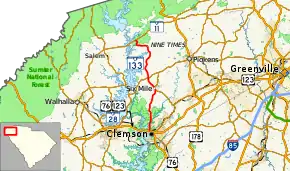
South Carolina Highway 133 (SC 133) is a 20.540-mile (33.056 km) state highway in Pickens County, South Carolina, connecting Clemson and western Pickens County with access to the Blue Ridge Mountains and the SC 11 (Cherokee Foothills Scenic Highway).
| ||||
|---|---|---|---|---|
 | ||||
| Route information | ||||
| Maintained by SCDOT | ||||
| Length | 20.540 mi[1] (33.056 km) | |||
| Existed | 1960s–present | |||
| Major junctions | ||||
| South end | ||||
| North end | ||||
| Location | ||||
| Counties | Pickens | |||
| Highway system | ||||
| ||||

Route description
The route of SC 133 travels generally in a south–north direction, beginning at an intersection with U.S. Routes 76 (US 76) and 123 and SC 28 in Clemson. SC 133 passes under a Norfolk Southern railway viaduct and leaves the Clemson area, passing by Lake Hartwell. The highway skirts rural areas west of Central before entering the community of Six Mile. North of Six Mile, SC 133 becomes more rural and hilly in nature before terminating at SC 11, near Lake Jocassee and Devils Fork State Park.[2]
Prior to streetscaping activities in downtown Clemson, the route used to include College Avenue and terminated at SC 93 at the front of the campus of Clemson University.
History
Junction list
The entire route is in Pickens County.
| Location | mi[1] | km | Destinations | Notes | |
|---|---|---|---|---|---|
| Clemson | 0.000 | 0.000 | Southern terminus; roadway continues as College Avenue. | ||
| Six Mile | 8.120 | 13.068 | Southern end of SC 137 concurrency | ||
| 8.590 | 13.824 | Northern end of SC 137 concurrency | |||
| | 10.760 | 17.317 | |||
| Keowee-Toxaway State Park | 20.540 | 33.056 | Northern terminus | ||
1.000 mi = 1.609 km; 1.000 km = 0.621 mi
| |||||
See also
 U.S. roads portal
References
- "Highway Logmile Report". South Carolina Department of Transportation. Retrieved December 25, 2020.
- Google (May 6, 2018). "South Carolina Highway 133" (Map). Google Maps. Google. Retrieved May 6, 2018.
External links
 Media related to South Carolina Highway 133 at Wikimedia Commons
- SC 133 at Virginia Highways' South Carolina Highways Annex