South Carolina Highway 181
South Carolina Highway 181 (SC 181) is a 6.430-mile-long (10.348 km) state highway in the U.S. state of South Carolina. The highway connects the Georgia state line with Starr.
| ||||
|---|---|---|---|---|
| Smith–McGee Road | ||||
 | ||||
| Route information | ||||
| Maintained by SCDOT | ||||
| Length | 6.430 mi[1] (10.348 km) | |||
| Existed | 1942–present | |||
| Major junctions | ||||
| South end | ||||
| North end | ||||
| Location | ||||
| Counties | Anderson | |||
| Highway system | ||||
| ||||

Route description
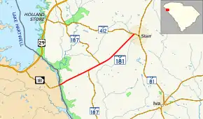
SC 181 begins at the Georgia state line at a point southwest of Starr, within Anderson County, where the roadway crosses over the Savannah River and continues as Georgia State Route 181 (Smith–McGee Highway). It travels to the northeast and has a brief concurrency with SC 187. The highway continues to the northeast and enters Starr. There, it meets its northern terminus, an intersection with SC 412 (Rainey Road/Stones Throw Avenue). Here, the roadway continues as Smith–McGee Road.[2]
Major intersections
The entire route is in Anderson County.
| Location | mi[1] | km | Destinations | Notes | |
|---|---|---|---|---|---|
| | 0.000 | 0.000 | Continuation beyond Georgia state line over the Savannah River | ||
| | 2.370 | 3.814 | Southern end of SC 187 concurrency | ||
| | 3.190 | 5.134 | Northern end of SC 187 concurrency | ||
| Starr | 6.430 | 10.348 | Northern terminus | ||
1.000 mi = 1.609 km; 1.000 km = 0.621 mi
| |||||
See also
 U.S. roads portal
 United States portal
References
- "Highway Logmile Report". South Carolina Department of Transportation. Retrieved December 25, 2020.
- Google (May 19, 2016). "South Carolina Highway 181" (Map). Google Maps. Google. Retrieved May 19, 2016.
External links
 Media related to South Carolina Highway 181 at Wikimedia Commons
- SC 181 at Virginia Highways' South Carolina Highways Annex
This article is issued from Wikipedia. The text is licensed under Creative Commons - Attribution - Sharealike. Additional terms may apply for the media files.