South Carolina Highway 243
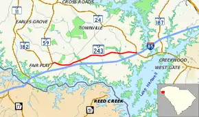
South Carolina Highway 243 (SC 243) is a 8.380-mile-long (13.486 km) state highway in the U.S. state of South Carolina. The highway travels on an east–west direction (though signed as north–south) from SC 59 and SC 182 in Fair Play to Interstate 85 (I-85) exit 11 and SC 24. The highway closely parallels I-85 to the north.
| ||||
|---|---|---|---|---|
 | ||||
| Route information | ||||
| Maintained by SCDOT | ||||
| Length | 8.380 mi[1][2] (13.486 km) | |||
| Existed | 1940–present | |||
| Major junctions | ||||
| West end | ||||
| East end | ||||
| Location | ||||
| Counties | Oconee, Anderson | |||
| Highway system | ||||
| ||||

Route description
SC 243 begins at an intersection with SC 59 and SC 182 in the census designated place of Fair Play, Oconee County. Numerous businesses surround the intersection which also is the southern terminus of SC 182. SC 243 travels east along East Fair Play Boulevard past houses, a store, churches, a cemetery, and a post office. Whitfield Road splits off from the road and travels south to I-85's exit 4. SC 243 continues east-northeast into Anderson County through a mix of farmland and woods. At the highway's end, it intersects SC 24 in front of a cafe. On the opposite side of SC 24, I-85's exit 11 southbound on and off-ramps are present. The northbound ramps of the interchange are located south of this point near SC 24.[3]
Major intersections
| County | Location | mi[1][2] | km | Destinations | Notes |
|---|---|---|---|---|---|
| Oconee | Fair Play | 0.000 | 0.000 | Western terminus of SC 243; southern terminus of SC 182 | |
| | 1.030 | 1.658 | Western terminus of Whitfield Road | ||
| Anderson | | 8.380 | 13.486 | Eastern terminus; I-85 exit 11 | |
| 1.000 mi = 1.609 km; 1.000 km = 0.621 mi | |||||
See also
 U.S. roads portal
References
- "Highway Logmile Report". South Carolina Department of Transportation. Retrieved December 26, 2020.
- "Highway Logmile Report". South Carolina Department of Transportation. Retrieved December 26, 2020.
- Google (January 7, 2017). "South Carolina Highway 243" (Map). Google Maps. Google. Retrieved January 7, 2017.
External links
| Wikimedia Commons has media related to South Carolina Highway 243. |