South Carolina Highway 24
South Carolina Highway 24 (SC 24) is a 30.660-mile-long (49.342 km) state highway in the U.S. state of South Carolina. The highway connects Westminster and Anderson.
| ||||
|---|---|---|---|---|
 | ||||
| Route information | ||||
| Maintained by SCDOT | ||||
| Length | 30.660 mi[1][2] (49.342 km) | |||
| Existed | 1938–present | |||
| Tourist routes | ||||
| Major junctions | ||||
| West end | ||||
| East end | ||||
| Location | ||||
| Counties | Oconee, Anderson | |||
| Highway system | ||||
| ||||

Route description
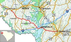
SC 24 begins at an intersection with U.S. Route 76 (US 76) and US 123 (East Main Street) in Westminster, within Oconee County, where the roadway continues as Oak Street. It travels to the southwest and immediately curves to the southeast before leaving the city limits. The highway passes by Pleasant Hill Cemetery and travels through rural areas of the county. Then, it has an intersection with SC 11. The highway continues traveling through rural areas of the county and has an intersection with SC 182 in Oakway. During a short east-northeast section, there is a very brief concurrency with SC 59. The highway passes by Hays Cemetery. SC 24 enters Anderson County and almost immediately has an interchange with Interstate 85 (I-85) which includes an intersection with SC 243 at its northern terminus. It crosses over part of Lake Hartwell on an unnamed bridge. A short distance later, it begins a concurrency with SC 187 at the Portman Shoals Intersection. The two highways cross over another part of the lake on the Calvin Wesley Belcher Bridge. It then enters West Gate, where SC 187 leaves the concurrency. SC 24 travels along the southern city limits of Centerville and passes just north of Anderson Regional Airport. In West Anderson, the highway passes Lakeside Middle School and intersects SC 28. About one mile (1.6 km) later, it enters the city limits of Anderson. Just under 4,000 feet (1,200 m) later, it meets its eastern terminus, an intersection with US 29 Business (US 29 Bus.)/US 76/US 178/SC 28 Bus./SC 81 (Murray Avenue).[3][4]
History
The first SC 24 was an original state highway, which operated as a spur from SC 12 in Hibernia, to Ninety Six. By 1926, SC 24 was extended southeast on new primary routing through Pelion to SC 6 in North. In 1928, SC 24 was extended south, from North, to SC 64 in Olar. In 1929, SC 24 was extended west, in concurrency with US 25 to Hodges, then replacing SC 25 to Donalds, and SC 15 to SC 2 in Clemson. That same year, SC 24 was rerouted to avoid Ninety Six, with its former route becoming SC 246. By 1930, SC 24 was rerouted at North, replacing SC 6 to Orangeburg then in concurrency with SC 2, through Bowman and Rosinville, to US 78. In 1931, SC 24 was extended west along SC 2, through Seneca and Walhalla, then solo through Mountain Rest to the Georgia state line; SC 24 reached its longest at approximately 231 miles (372 km). In 1933, US 178 replaced SC 24 between Anderson and US 78; SC 24 remained west of Anderson to Georgia. In 1938, SC 24 was renumbered as part of SC 28.
The second and current SC 24 was established in 1938 as a renumbering of SC 18, between Westminster and Anderson.[5][6] By 1964, SC 24 eastern terminus changed from Market and Main Streets to Whitier and Main Streets, coinciding with the elimination of SC 80.[7]
Major intersections
| County | Location | mi[1][2] | km | Destinations | Notes |
|---|---|---|---|---|---|
| Oconee | Westminster | 0.000 | 0.000 | Western terminus | |
| | 3.920 | 6.309 | Interchange | ||
| Oakway | 5.710 | 9.189 | Northern terminus of SC 182 | ||
| | 8.192 | 13.184 | Western end of SC 59 concurrency | ||
| | 8.501 | 13.681 | Eastern end of SC 59 concurrency | ||
| Anderson | | 18.810– 18.912 | 30.272– 30.436 | I-85 exit 11; eastern terminus of SC 243 | |
| | 21.513 | 34.622 | Western end of SC 187 concurrency; Portman Shoals Intersection | ||
| Lake Hartwell | 22.388– 22.641 | 36.030– 36.437 | Calvin Wesley Belcher Bridge | ||
| West Gate | 24.290 | 39.091 | Eastern end of SC 187 concurrency | ||
| West Anderson | 28.780 | 46.317 | |||
| Anderson | 30.660 | 49.342 | Eastern terminus | ||
1.000 mi = 1.609 km; 1.000 km = 0.621 mi
| |||||
See also
 U.S. roads portal
 United States portal
References
- "Highway Logmile Report". South Carolina Department of Transportation. Retrieved November 27, 2020.
- "Highway Logmile Report". South Carolina Department of Transportation. Retrieved November 27, 2020.
- Google (May 6, 2016). "Overview map of SC 24 (Westminster–West Gate)" (Map). Google Maps. Google. Retrieved May 6, 2016.
- Google (May 6, 2016). "Overview map of SC 24 (West Gate–Anderson)" (Map). Google Maps. Google. Retrieved May 6, 2016.
- General Highway Map, Oconee County, South Carolina (PDF) (Map). Cartography by SCDOT. South Carolina Department of Transportation. 1939. Retrieved May 19, 2016.
- General Highway Map, Anderson County, South Carolina (PDF) (Map). Cartography by SCDOT. South Carolina Department of Transportation. 1940. Retrieved May 19, 2016.
- General Highway Map, Anderson County, South Carolina (PDF) (Map). Cartography by SCDOT. South Carolina Department of Transportation. 1968. Retrieved May 19, 2016.
External links
 Media related to South Carolina Highway 24 at Wikimedia Commons
- Mapmikey's South Carolina Highways Page: SC 24