South Carolina Highway 267
South Carolina Highway 267 (SC 267) is a 23.200-mile-long (37.337 km) state highway in the U.S. state of South Carolina. The highway connects the Santee area with rural areas of Orangeburg and Calhoun counties, via Elloree.
| ||||
|---|---|---|---|---|
| ||||
| Route information | ||||
| Maintained by SCDOT | ||||
| Length | 23.200 mi[1][2] (37.337 km) | |||
| Major junctions | ||||
| South end | ||||
| North end | ||||
| Location | ||||
| Counties | Orangeburg, Calhoun | |||
| Highway system | ||||
| ||||

Route description
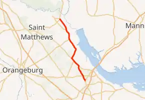
SC 267 begins at an intersection with U.S. Route 15 (US 15; Bass Drive) south-southwest of Santee, within Orangeburg County. It travels to the north-northwest and crosses over Providence Swamp before intersecting US 301 (Five Chop Road). The highway curves to the north and crosses railroad tracks and intersects SC 6 (Old Number Six Highway) southeast of Elloree. The highways travel concurrently to the northwest into Elloree. There, they intersect the northern terminus of SC 47 (West Cleveland Street). Just before leaving town, they pass Joe Miller Park. Approximately 2,000 feet (610 m) later, they split, with SC 267 heading to the north-northeast. The highway enters Calhoun County just before Peachtree Road. Then, SC 267 curves to the north-northwest. It crosses over Halfway Swamp Creek. It crosses some railroad tracks and passes by, but does not enter, Lone Star. It intersects the northern terminus of SC 33 (Cameron Road) northwest of Lone Star. The highway curves to the north and curves back to the northwest and crosses Warley Creek. It intersects SC 419 (Fort Motte Road). SC 267 crosses Squirrel Creek before meeting its northern terminus, an intersection with US 601 (Colonel Thomson Highway) southeast of Fort Motte, where the roadway continues as Adams Road.[3]
Major intersections
| County | Location | mi[1][2] | km | Destinations | Notes |
|---|---|---|---|---|---|
| Orangeburg | | 0.000 | 0.000 | Southern terminus | |
| | 1.710 | 2.752 | |||
| | 5.480 | 8.819 | Southern end of SC 6 concurrency | ||
| Elloree | 7.480 | 12.038 | Northern terminus of SC 47 | ||
| | 8.750 | 14.082 | Northern end of SC 6 concurrency | ||
| Calhoun | | 15.840 | 25.492 | Northern terminus of SC 33 | |
| | 18.910 | 30.433 | Southern terminus of SC 419 | ||
| | 23.200 | 37.337 | Northern terminus | ||
1.000 mi = 1.609 km; 1.000 km = 0.621 mi
| |||||
See also
 U.S. roads portal
 United States portal
References
- "Highway Logmile Report". South Carolina Department of Transportation. Retrieved November 25, 2020.
- "Highway Logmile Report". South Carolina Department of Transportation. Retrieved November 25, 2020.
- Google (May 12, 2016). "South Carolina Highway 267" (Map). Google Maps. Google. Retrieved May 12, 2016.
External links
 Media related to South Carolina Highway 267 at Wikimedia Commons
- SC 267 South Carolina Hwy Index