St. Matthews, South Carolina
St. Matthews is a town in Calhoun County, South Carolina, United States. The population was 2,021 at the 2010 census,[5] a decline from 2,107 in 2000. It is the county seat of Calhoun County.[6]
St. Matthews, South Carolina | |
|---|---|
 | |
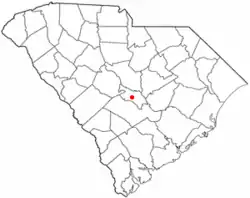 Location of St. Matthews, South Carolina | |
| Coordinates: 33°39′53″N 80°46′44″W | |
| Country | United States |
| State | South Carolina |
| County | Calhoun |
| Founded | 1841 |
| Government | |
| • Mayor | Helen Carson-Peterson |
| Area | |
| • Total | 1.93 sq mi (4.99 km2) |
| • Land | 1.92 sq mi (4.98 km2) |
| • Water | 0.01 sq mi (0.02 km2) |
| Elevation | 279 ft (85 m) |
| Population (2010) | |
| • Total | 2,021 |
| • Estimate (2019)[2] | 1,912 |
| • Density | 994.80/sq mi (384.15/km2) |
| Time zone | UTC-5 (EST) |
| • Summer (DST) | UTC-4 (EDT) |
| ZIP Code | 29135 |
| Area code(s) | 803 |
| FIPS code | 45-62620[3] |
| GNIS feature ID | 1250621[4] |
| Website | stmatthews |
St. Matthews is part of the Columbia, South Carolina Metropolitan Statistical Area.
The town holds an annual Purple Martin festival in April which includes food, music, cars, and more.[7]
History
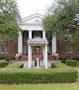
St. Matthews was established as the township of Amelia by Gov. Robert Johnson in the 1730s.[8] The Col. J.A. Banks House, Buyck's Bluff Archeological Site, Calhoun County Courthouse, Calhoun County Library, Cherokee Path, Sterling Land Grant, Col. Olin M. Dantzler House, David Houser House, Prehistoric Indian Village, and Puritan Farm are listed on the National Register of Historic Places.[9]
Geography
St. Matthews is located in the center of Calhoun County at 33°39′53″N 80°46′44″W (33.664734, -80.778976).[10] U.S. Route 601 passes through the town, leading northeast 51 miles (82 km) to Camden and southwest 13 miles (21 km) to Orangeburg. South Carolina Highway 6 crosses US 601 in the center of town and leads west 7 miles (11 km) to Interstate 26 and southeast 22 miles (35 km) to Interstate 95 near Santee.
According to the United States Census Bureau, St. Matthews has a total area of 1.93 square miles (4.99 km2), of which 1.92 square miles (4.97 km2) is land and 0.01 square miles (0.02 km2), or 0.35%, is water.[5]
Education
Public education in St. Matthews is administered by Calhoun County School District. The district operates St. Matthews K-8 School, Sandy Run K-8 School, and Calhoun County High School.[11]
Calhoun Academy, a school founded as a segregation academy, remains a private institution.[12]
St. Matthews has a lending library, the Calhoun County Public Library.[13]
Notable people
- Mike Colter, actor
- Viola Davis, Academy Award-winning actress
- Clarence Felder, actor
- Alshon Jeffery, Philadelphia Eagles (NFL) and (former) University of South Carolina wide receiver; Super Bowl LII champion
- Ludwig Lewisohn, writer, critic and poet
- Phillip Merling, Miami Dolphins defensive end in the NFL
- Horace Ott, musician, orchestral conductor and songwriter
- Eartha Kitt, singer, actress, dancer and activist
- James "Blood" Ulmer, jazz and blues guitarist
- Othniel Wienges, politician and horse breeder
- Webb Carroll, horse trainer and founder of Webb Carroll Training Center
Demographics
| Historical population | |||
|---|---|---|---|
| Census | Pop. | %± | |
| 1880 | 271 | — | |
| 1890 | 524 | 93.4% | |
| 1900 | 758 | 44.7% | |
| 1910 | 1,377 | 81.7% | |
| 1920 | 1,780 | 29.3% | |
| 1930 | 1,750 | −1.7% | |
| 1940 | 2,187 | 25.0% | |
| 1950 | 2,351 | 7.5% | |
| 1960 | 2,433 | 3.5% | |
| 1970 | 2,403 | −1.2% | |
| 1980 | 2,496 | 3.9% | |
| 1990 | 2,345 | −6.0% | |
| 2000 | 2,107 | −10.1% | |
| 2010 | 2,021 | −4.1% | |
| 2019 (est.) | 1,912 | [2] | −5.4% |
| U.S. Decennial Census[14] | |||
As of the census[3] of 2000, there were 2,107 people, 823 households, and 549 families residing in the town. The population density was 1,091.1 people per square mile (421.5/km2). There were 913 housing units at an average density of 472.8 per square mile (182.6/km2). The racial makeup of the town was 37.16% White, 61.46% African American, 0.05% Native American, 0.09% Asian, 0.14% Pacific Islander, 0.38% from other races, and 0.71% from two or more races. Hispanic or Latino of any race were 1.33% of the population.
There were 823 households, out of which 27.2% had children under the age of 18 living with them, 41.8% were married couples living together, 21.4% had a female householder with no husband present, and 33.2% were non-families. 30.6% of all households were made up of individuals, and 14.9% had someone living alone who was 65 years of age or older. The average household size was 2.39 and the average family size was 3.00.
In the town, the population was spread out, with 23.5% under the age of 18, 6.2% from 18 to 24, 23.3% from 25 to 44, 24.0% from 45 to 64, and 23.0% who were 65 years of age or older. The median age was 43 years. For every 100 females, there were 72.8 males. For every 100 females age 18 and over, there were 66.3 males.
The median income for a household in the town was $24,969, and the median income for a family was $36,250. Males had a median income of $29,760 versus $21,311 for females. The per capita income for the town was $14,911. About 19.5% of families and 24.0% of the population were below the poverty line, including 32.8% of those under age 18 and 21.4% of those age 65 or over.
References
- "2019 U.S. Gazetteer Files". United States Census Bureau. Retrieved July 29, 2020.
- "Population and Housing Unit Estimates". United States Census Bureau. May 24, 2020. Retrieved May 27, 2020.
- "U.S. Census website". United States Census Bureau. Retrieved 2008-01-31.
- "US Board on Geographic Names". United States Geological Survey. 2007-10-25. Retrieved 2008-01-31.
- "Geographic Identifiers: 2010 Census Summary File 1 (G001): St. Matthews town, South Carolina". U.S. Census Bureau, American Factfinder. Archived from the original on February 13, 2020. Retrieved June 25, 2015.
- "Find a County". National Association of Counties. Retrieved 2011-06-07.
- Jordan, Larry (24 February 2019). "St. Mathews Purple Martin Festival". T&D. T&D. Retrieved 27 November 2019.
- Jones, Lewis P. (1971). South Carolina: A Synoptic History for Laymen. Orangeburg: Sandlapper. pp. 52–53.
- "National Register Information System". National Register of Historic Places. National Park Service. July 9, 2010.
- "US Gazetteer files: 2010, 2000, and 1990". United States Census Bureau. 2011-02-12. Retrieved 2011-04-23.
- "Homepage". Calhoun County Public Schools. Retrieved 7 June 2019.
- Carol Innerst (March 6, 1990). "All-white school loses its tax status". The Washington Times. Retrieved September 3, 2012.
- "South Carolina libraries and archives". SCIWAY. Retrieved 7 June 2019.
- "Census of Population and Housing". Census.gov. Retrieved June 4, 2015.
External links
| Wikimedia Commons has media related to St. Matthews, South Carolina. |
- Calhoun County Museum and Cultural Center
- Information about St. Matthews from the Calhoun County Chamber of Commerce
Municipalities and communities of Calhoun County, South Carolina, United States | ||
|---|---|---|
| Towns |  Map of South Carolina highlighting Calhoun County | |
| Unincorporated communities | ||
| ||
| Authority control |
|---|