South Carolina Highway 60
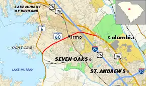
South Carolina Highway 60 (SC 60) is a 5.160-mile (8.304 km) primary state highway in the U.S. state of South Carolina. It serves the town of Irmo, connecting nearby Lake Murray and Harbison State Forest.
| ||||
|---|---|---|---|---|
| Lake Murray Boulevard | ||||
 | ||||
| Route information | ||||
| Maintained by SCDOT | ||||
| Length | 5.160 mi[1][2] (8.304 km) | |||
| Existed | 1929–present | |||
| Major junctions | ||||
| West end | ||||
| East end | ||||
| Location | ||||
| Counties | Lexington, Richland | |||
| Highway system | ||||
| ||||

Route description
SC 60 is a mostly four-lane with median suburban highway that travels 5.16 miles (8.30 km) from SC 6 to U.S. Route 176 (US 176), with an interchange with Interstate 26 (I-26)/US 76.[3]
History
SC 60 was established in 1929 as a new primary routing. The route has remained unchanged since inception, though its eastern endpoint was originally US 76/SC 2; the highway was widened to mostly four lanes with median by 2000.
Junction list
| County | Location | mi[1][2] | km | Destinations | Notes |
|---|---|---|---|---|---|
| Lexington | | 0.000 | 0.000 | Western terminus of SC 60 and Bush River Road | |
| Richland | Irmo | 3.720– 3.744 | 5.987– 6.025 | I-26 exit 102A–B | |
| St. Andrews–Columbia line | 5.160 | 8.304 | Eastern terminus | ||
| 1.000 mi = 1.609 km; 1.000 km = 0.621 mi | |||||
See also
 U.S. roads portal
References
- "Highway Logmile Report". South Carolina Department of Transportation. Retrieved December 23, 2020.
- "Highway Logmile Report". South Carolina Department of Transportation. Retrieved December 23, 2020.
- Google (September 6, 2013). "South Carolina Highway 60" (Map). Google Maps. Google. Retrieved September 6, 2013.
External links
 Media related to South Carolina Highway 60 at Wikimedia Commons
- SC 60 at Virginia Highways' South Carolina Highways Annex
This article is issued from Wikipedia. The text is licensed under Creative Commons - Attribution - Sharealike. Additional terms may apply for the media files.