South Carolina Highway 88
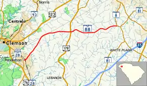
South Carolina Highway 88 (SC 88) is a 14.350-mile (23.094 km) state highway in northern Anderson County, South Carolina with a brief entry into southern Pickens County, connecting Pendleton and areas south of Powdersville. It is sometimes considered an alternate route for U.S. Route 123 (US 123).
| ||||
|---|---|---|---|---|
 | ||||
| Route information | ||||
| Maintained by SCDOT | ||||
| Length | 14.350 mi[1] (23.094 km) | |||
| Existed | 1960s–present | |||
| Major junctions | ||||
| West end | North Broad Street in Pendleton | |||
| East end | ||||
| Location | ||||
| Counties | Anderson, Pickens | |||
| Highway system | ||||
| ||||

Route description
The route travels generally in a west–east direction, signed to begin at an intersection with SC 28 Business (SC 28 Bus.; North Mechanic Street) in downtown Pendleton. However, SCDOT designates the western terminus to not start until North Broad Street a few blocks later. East of Pendleton, SC 88 travels through somewhat rural areas and has a flashing stop light intersection with US 178. The route continues until it terminates at an intersection with SC 8, west of the suburban areas of Powdersville.[2][3]
History
Major intersections
| County | Location | mi[1] | km | Destinations | Notes | |||
|---|---|---|---|---|---|---|---|---|
| Anderson | Pendleton | −0.150 | −0.241 | Signed western terminus | ||||
| 0.000 | 0.000 | North Broad Street / East Queen Street west – Tri-County Technical College | Official western terminus; East Queen Street continues past intersection. | |||||
| Pickens |
No major junctions | |||||||
| Anderson | | 7.870 | 12.666 | |||||
| | 14.350 | 23.094 | ||||||
| 1.000 mi = 1.609 km; 1.000 km = 0.621 mi | ||||||||
See also
 U.S. roads portal
References
- "Highway Logmile Report". South Carolina Department of Transportation. Retrieved December 24, 2020.
- General Highway System - Anderson County, South Carolina (PDF) (Map). South Carolina Department of Transportation. August 2005. Retrieved September 7, 2013.
- General Highway System - Pickens County, South Carolina (PDF) (Map). South Carolina Department of Transportation. August 2005. Retrieved September 7, 2013.
External links
 Media related to South Carolina Highway 88 at Wikimedia Commons