South Carolina Highway 917
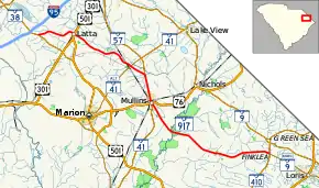
South Carolina Highway 917 (SC 917) is a 39.690-mile (63.875 km) state highway in the northeastern part of the U.S. state of South Carolina. It travels from the SC 410/SC 9 Business (SC 9 Bus.) intersection between Green Sea and Loris in Horry County to the SC 38 intersection outside Latta in Dillon County.
| ||||
|---|---|---|---|---|
 | ||||
| Route information | ||||
| Maintained by SCDOT | ||||
| Length | 39.690 mi[1][2][3] (63.875 km) | |||
| Existed | 1940–present | |||
| Major junctions | ||||
| South end | ||||
| North end | ||||
| Location | ||||
| Counties | ||||
| Highway system | ||||
| ||||

Route description
The highway travels in a southeast-to-northwest direction, but is signed as a north–south highway. It travels between SC 410/SC 9 Bus. in the community of Finklea, through Mullins where it has a concurrency with SC 41 and intersects US 76, Latta where it intersects U.S. Route 301 (US 301) and US 501, to SC 38 south of its interchange with I-95.[4]
History
South Carolina Highway 73
| |
|---|---|
| Location | Latta, South Carolina |
| Existed | 1939–1942 |
South Carolina Highway 73 (SC 73) was a state highway that was established in 1939 from US 301/US 501 in Latta southeast to SC 57 (now SC 41) south-southeast of Fork. In 1942, it was decommissioned and redesignated as SC 573. Today, most of its path is part of SC 917.
Major intersections
| County | Location[4] | mi[1][2][3] | km | Destinations | Notes |
|---|---|---|---|---|---|
| Horry | Finklea | 0.000 | 0.000 | Continuation southeast beyond southern terminus | |
| Southern terminus | |||||
| Marion | Mullins | 18.990 | 30.561 | Southern end of SC 41 concurrency | |
| 19.140 | 30.803 | ||||
| | 23.020 | 37.047 | Northern end of SC 41 concurrency | ||
| Marion–Dillon county line | Smithboro | 25.310 | 40.732 | ||
| Dillon | Latta | 34.460 | 55.458 | ||
| | 39.690 | 63.875 | Northern terminus | ||
1.000 mi = 1.609 km; 1.000 km = 0.621 mi
| |||||
See also
![]() U.S. roads portal
U.S. roads portal
References
- "Highway Logmile Report". South Carolina Department of Transportation. Retrieved December 29, 2020.
- "Highway Logmile Report". South Carolina Department of Transportation. Retrieved December 29, 2020.
- "Highway Logmile Report". South Carolina Department of Transportation. Retrieved December 29, 2020.
- Google (February 25, 2018). "Overview map of SC 917" (Map). Google Maps. Google. Retrieved February 25, 2018.
External links
| Wikimedia Commons has media related to South Carolina Highway 917. |