South Dakota Highway 253
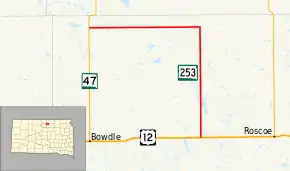
South Dakota Highway 253 (SD 253) is an 18.024-mile-long (29.007 km) state highway in the north-central part of the U.S. state of South Dakota. It exists entirely within Edmunds County, from U.S. Route 12 (US 12) west of Roscoe to SD 47 north of Bowdle. The route is maintained by the South Dakota Department of Transportation (SDDOT) and is not a part of the National Highway System.
| ||||
|---|---|---|---|---|
 | ||||
| Route information | ||||
| Defined by SDCL §31-4-223 | ||||
| Maintained by SDDOT | ||||
| Length | 18.024 mi[1] (29.007 km) | |||
| Existed | 1975[2]–present | |||
| Major junctions | ||||
| South end | ||||
| North end | ||||
| Location | ||||
| Counties | Edmunds | |||
| Highway system | ||||
| ||||

Route description
SD 253 begins at an intersection with US 12 near Gretna and heads north through flat farmland. It passes a railroad almost immediately and continues north. The route passes by a couple of lakes and turns west. Directly after turning east, SD 253 enters the city of Hosmer. After running through the city, the highway passes by a cemetery and treks west. The route reaches its northern terminus approximately eight miles (13 km) west of Hosmer at an intersection with SD 47.[3][4]
SD 253 is maintained by SDDOT. In 2012, the traffic on the road was measured in average annual daily traffic. The highway had an average of 214 vehicles on the north–south segment and an average of 195 vehicles on the east–west segment.[1] The designation is not a part of the National Highway System,[5] a system of highways important to the nation's defense, economy, and mobility.[6]
Major intersections
The entire route is in Edmunds County.
| Location | mi[1] | km | Destinations | Notes | |
|---|---|---|---|---|---|
| Cottonwood Lake–Glen township line | 0.000 | 0.000 | Southern terminus of SD 253; northern terminus of CR 5 | ||
| Modena Township | 18.024 | 29.007 | Northern terminus of SD 253; eastern terminus of CR 2W | ||
| 1.000 mi = 1.609 km; 1.000 km = 0.621 mi | |||||
References
- "State Highway Log" (PDF). South Dakota Department of Transportation. January 2012. Retrieved March 9, 2013.
- "Highway Division Makes Road Numbering Changes". The Sioux Falls Argus-Leader. March 20, 1975. p. 2 (32). Retrieved March 18, 2020 – via Newspapers.com.

- Google (March 9, 2013). "South Dakota Highway 253" (Map). Google Maps. Google. Retrieved March 9, 2013.
- South Dakota Atlas & Gazetteer. Yarmouth, ME: DeLorme. 2009. pp. 18, 19. ISBN 0-89933-330-3.
- National Highway System: South Dakota (PDF) (Map). Federal Highway Administration. October 1, 2012. Retrieved March 9, 2013.
- Natzke, Stefan; Neathery, Mike; Adderly, Kevin (September 26, 2012). "What is the National Highway System?". National Highway System. Federal Highway Administration. Retrieved March 9, 2013.