South Dakota Highway 258
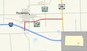
South Dakota Highway 258 (SD 258) is a 2.552-mile-long (4.107 km) state highway in Aurora County, South Dakota. It runs from Interstate 90 (I-90) to U.S. Route 281 (US 281), and is maintained by the South Dakota Department of Transportation (SDDOT). The route is not a part of the National Highway System.
| ||||
|---|---|---|---|---|
 | ||||
| Route information | ||||
| Defined by SDCL §31-4-224 | ||||
| Maintained by SDDOT | ||||
| Length | 2.552 mi[1] (4.107 km) | |||
| Major junctions | ||||
| West end | ||||
| East end | ||||
| Location | ||||
| Counties | Aurora | |||
| Highway system | ||||
| ||||

Route description
SD 258 begins at a diamond interchange with exit 308 of I-90 and travels north. The route enters the city of Plankinton almost immediately and continues north. The highway turns east onto Davenport Street in Plankinton and a curve takes the highway to the northeast. After leaving Plankinton, the road curves back to the east and continues through open plains for about one mile (1.6 km) before reaching its eastern terminus at an intersection with US 281. The roadway continues east of this intersection as County Road 34.[2][3]
SD 258 is maintained by SDDOT. In 2012, the traffic on the road was measured in average annual daily traffic. SD 258 was measured at 900 vehicles.[1] The highway is not a part of the National Highway System,[4] a system of highways important to the nation's defense, economy, and mobility.[5]
Major intersections
The entire route is in Aurora County.
| Location | mi[1] | km | Destinations | Notes | |
|---|---|---|---|---|---|
| Plankinton Township | 0.000 | 0.000 | Western terminus | ||
| 1.627 | 2.618 | ||||
| Plankinton–Hopper township line | 2.552 | 4.107 | Eastern terminus | ||
| 1.000 mi = 1.609 km; 1.000 km = 0.621 mi | |||||
References
- "State Highway Log" (PDF). South Dakota Department of Transportation. January 2012. Retrieved March 10, 2013.
- Google (March 10, 2013). "South Dakota Highway 258" (Map). Google Maps. Google. Retrieved March 10, 2013.
- South Dakota Atlas & Gazetteer. Yarmouth, ME: DeLorme. 2009. p. 56. ISBN 0-89933-330-3.
- National Highway System: South Dakota (PDF) (Map). Federal Highway Administration. October 1, 2012. Retrieved March 10, 2013.
- Natzke, Stefan; Neathery, Mike; Adderly, Kevin (September 26, 2012). "What is the National Highway System?". National Highway System. Federal Highway Administration. Retrieved March 10, 2013.