Edmunds County, South Dakota
Edmunds County is a county in the U.S. state of South Dakota. At the 2010 United States Census, the population was 4,071.[1] Its county seat is Ipswich.[2] The county was established in 1873 and organized in 1883.[3] It is named for Newton Edmunds, the second Governor of Dakota Territory.[4]
Edmunds County | |
|---|---|
 | |
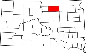 Location within the U.S. state of South Dakota | |
 South Dakota's location within the U.S. | |
| Coordinates: 45°25′N 99°13′W | |
| Country | |
| State | |
| Founded | 1873 (founded) 1883 (organized) |
| Named for | Newton Edmunds |
| Seat | Ipswich |
| Largest city | Ipswich |
| Area | |
| • Total | 1,151 sq mi (2,980 km2) |
| • Land | 1,126 sq mi (2,920 km2) |
| • Water | 25 sq mi (60 km2) 2.2% |
| Population (2010) | |
| • Total | 4,071 |
| • Estimate (2018) | 3,875 |
| • Density | 3.5/sq mi (1.4/km2) |
| Time zone | UTC−6 (Central) |
| • Summer (DST) | UTC−5 (CDT) |
| Congressional district | At-large |
| Website | edmunds |
Edmunds County is part of the Aberdeen, SD Micropolitan Statistical Area.
Geography
The terrain of Edmunds County consists of rolling hills, mostly dedicated to agriculture. The terrain's highest point is on the west portion of the north boundary line, at 1,978' (603m) ASL.[5] The county has a total area of 1,151 square miles (2,980 km2), of which 1,126 square miles (2,920 km2) is land and 25 square miles (65 km2) (2.2%) is water.[6]
Major highways
Adjacent counties
- McPherson County - north
- Brown County - east
- Faulk County - south
- Potter County - southwest
- Walworth County - west
Protected areas
- Bowdle-Hosmer State Game Production Area[7]
- Heilman State Game Production Area[8]
- Hosmer State Game Production Area[9]
- Light State Game Production Area
- Losee State Game Production Area
- Mina Lake State Recreation Area[10]
- Mina State Game Production Area
- North Scatterwood State Game Production Area
- Rosette State Game Production Area
- Schaber State Game Production Area
- Shaner State Game Production Area
- Steigelmier State Game Production Area[11]
Lakes
- Alkali Lake
- Bowdle-Hosmer Lake
- Grass Lake
- Lake Parmley
- North Scatterwood Lake (partial)
Demographics
| Historical population | |||
|---|---|---|---|
| Census | Pop. | %± | |
| 1890 | 4,399 | — | |
| 1900 | 4,916 | 11.8% | |
| 1910 | 7,654 | 55.7% | |
| 1920 | 8,336 | 8.9% | |
| 1930 | 8,712 | 4.5% | |
| 1940 | 7,814 | −10.3% | |
| 1950 | 7,275 | −6.9% | |
| 1960 | 6,079 | −16.4% | |
| 1970 | 5,548 | −8.7% | |
| 1980 | 5,159 | −7.0% | |
| 1990 | 4,356 | −15.6% | |
| 2000 | 4,367 | 0.3% | |
| 2010 | 4,071 | −6.8% | |
| 2019 (est.) | 3,829 | [12] | −5.9% |
| US Decennial Census[13] 1790-1960[14] 1900-1990[15] 1990-2000[16] 2010-2018[1] | |||
2000 census
In the 2000 census,[17] there were 4,367 people, 1,681 households and 1,210 families in the county. The population density was 4 per square mile (1.5/km2). There were 2,022 housing units at an average density of 2 per square mile (0.77/km2). The racial make-up of the county was 99.20% White, 0.07% Black or African American, 0.25% Native American, 0.09% Asian, 0.02% Pacific Islander, 0.05% from other races, and 0.32% from two or more races. 0.48% of the population were Hispanic or Latino of any race. 69.4% were of German and 6.2% Norwegian ancestry.
There were 1,681 households, of which 31.50% had children under the age of 18 living with them, 64.90% were married couples living together, 4.80% had a female householder with no husband present, and 28.00% were non-families. 25.60% of all households were made up of individuals, and 15.00% had someone living alone who was 65 years of age or older. The average household size was 2.52 and the average family size was 3.04.
26.70% of the population were under the age of 18, 5.10% from 18 to 24, 23.30% from 25 to 44, 22.70% from 45 to 64, and 22.20% who were 65 years of age or older. The median age was 42 years. For every 100 females, there were 97.20 males. For every 100 females age 18 and over, there were 94.30 males.
The median household income was $32,205 and the median family income was $37,174. Males had a median income of $26,609 and females $18,080. The per capita income was $16,149. About 10.40% of families and 13.80% of the population were below the poverty line, including 16.80% of those under age 18 and 14.00% of those age 65 or over.
2010 census
At the 2010 census, there were 4,071 people, 1,607 households and 1,057 families residing in the county.[18] The population density was 3.6 per square mile (1.4/km2). There were 1,966 housing units at an average density of 1.7 per square mile (0.66/km2).[19] The racial make-up of the county was 97.8% white, 0.4% American Indian, 0.1% black or African American, 0.1% Asian, 0.5% from other races, and 1.0% from two or more races. Those of Hispanic or Latino origin made up 1.4% of the population.[18] In terms of ancestry, 70.8% were German, 11.4% were Norwegian, 10.1% were Russian, 5.9% were English and 2.4% were American.[20]
Of the 1,607 households, 26.4% had children under the age of 18 living with them, 58.9% were married couples living together, 4.0% had a female householder with no husband present, 34.2% were non-families, and 31.0% of all households were made up of individuals. The average household size was 2.27 and the average family size was 2.84. The median age was 45.7 years.[18]
The median household income was $47,026 and the median family income was $56,599. Males had a median income of $37,713 and females $26,287. The per capita income was $24,268. About 6.9% of families and 11.6% of the population were below the poverty line, including 11.0% of those under age 18 and 13.6% of those age 65 or over.[21]
Notable events
Edmunds County is where the Learjet of the PGA golfer Payne Stewart crashed, killing him and five others on board. The plane crashed just south of the community of Mina at the approximate coordinates of 45°25' N 98°45' W.
Communities
Townships
- Adrian
- Belle
- Bowdle
- Bryant
- Clear Lake
- Cleveland
- Cloyd
- Cordlandt
- Cottonwood Lake
- Fountain
- Glen
- Glover
- Harmony
- Hillside
- Hosmer
- Hudson
- Huntley
- Ipswich
- Kent
- Liberty
- Madison
- Modena
- Montpelier
- North Bryant
- Odessa
- Pembrook
- Powell
- Richland
- Rosette
- Sangamon
- Union
- Vermont
Politics
Edmunds County voters have long been reliably Republican. Since 1936, in only three elections has the county selected the Democratic Party candidate. Although it was one of only 130 counties nationwide to back George McGovern in his landslide 1972 defeat, it has voted for fewer Democratic presidential nominees (six) than any other county McGovern carried, with Jimmy Carter in 1976 the last Democrat to carry the county and Hillary Clinton not passing twenty percent in 2016.
| Year | Republican | Democratic | Third parties |
|---|---|---|---|
| 2016 | 74.7% 1,433 | 19.8% 380 | 5.5% 105 |
| 2012 | 65.3% 1,264 | 32.1% 622 | 2.6% 50 |
| 2008 | 58.4% 1,213 | 39.5% 819 | 2.1% 44 |
| 2004 | 64.2% 1,434 | 34.2% 765 | 1.6% 35 |
| 2000 | 63.3% 1,257 | 34.0% 676 | 2.7% 53 |
| 1996 | 45.7% 1,055 | 42.1% 973 | 12.2% 282 |
| 1992 | 41.8% 944 | 39.6% 894 | 18.7% 422 |
| 1988 | 51.1% 1,327 | 48.4% 1,259 | 0.5% 13 |
| 1984 | 60.4% 1,553 | 39.2% 1,007 | 0.4% 10 |
| 1980 | 64.6% 1,881 | 30.3% 883 | 5.2% 150 |
| 1976 | 44.1% 1,294 | 55.6% 1,629 | 0.3% 9 |
| 1972 | 48.7% 1,567 | 51.2% 1,646 | 0.1% 3 |
| 1968 | 52.2% 1,534 | 41.7% 1,225 | 6.2% 181 |
| 1964 | 45.8% 1,442 | 54.2% 1,708 | |
| 1960 | 51.8% 1,728 | 48.2% 1,609 | |
| 1956 | 51.6% 1,685 | 48.4% 1,580 | |
| 1952 | 68.3% 2,178 | 31.8% 1,013 | |
| 1948 | 54.0% 1,493 | 45.3% 1,253 | 0.7% 19 |
| 1944 | 64.7% 1,762 | 35.3% 961 | |
| 1940 | 61.9% 2,341 | 38.1% 1,443 | |
| 1936 | 46.8% 1,818 | 52.2% 2,030 | 1.0% 40 |
| 1932 | 30.8% 1,183 | 67.5% 2,588 | 1.7% 65 |
| 1928 | 52.0% 1,743 | 47.6% 1,597 | 0.5% 15 |
| 1924 | 42.4% 1,043 | 11.3% 277 | 46.4% 1,141 |
| 1920 | 60.4% 1,486 | 11.5% 283 | 28.2% 693 |
| 1916 | 55.5% 894 | 39.3% 634 | 5.2% 84 |
| 1912 | 49.1% 729 | 50.9% 755 | |
| 1908 | 50.1% 726 | 45.4% 658 | 4.4% 64 |
| 1904 | 65.9% 786 | 29.6% 353 | 4.5% 54 |
| 1900 | 52.0% 621 | 46.3% 553 | 1.8% 21 |
| 1896 | 41.8% 371 | 57.4% 510 | 0.8% 7 |
| 1892 | 44.2% 386 | 17.9% 156 | 37.9% 331 |
References
- "State & County QuickFacts". United States Census Bureau. Archived from the original on June 7, 2011. Retrieved November 25, 2013.
- "Find a County". National Association of Counties. Archived from the original on July 4, 2012. Retrieved 7 June 2011.
- "Dakota Territory, South Dakota, and North Dakota: Individual County Chronologies". Dakota Territory Atlas of Historical County Boundaries. The Newberry Library. 2006. Retrieved March 29, 2015.
- Gannett, Henry (1905). The Origin of Certain Place Names in the United States. Govt. Print. Off. p. 115.
- ""Find an Altitude" Google Maps (accessed 2 February 2019)". Archived from the original on May 21, 2019. Retrieved February 3, 2019.
- "2010 Census Gazetteer Files". US Census Bureau. August 22, 2012. Retrieved March 24, 2015.
- Bowdle-Hosmer Public Shooting Area, Bowdle SD, Google Maps. Retrieved February 2, 2019.
- Heilman State Public Shooting Area, Bowdle SD, Google Maps. Retrieved February 2, 2019.
- Hosmer State Public Shooting Area, Hosmer SD, Google Maps. Retrieved February 2, 2019.
- Mina Lake State Recreation Area, Google Maps. Retrieved February 2, 2019.
- Steigelmier State Public Shooting Area, Onaka SD, Google Maps. Retrieved February 2, 2019.
- "Annual Estimates of the Resident Population for Counties: April 1, 2010 to July 1, 2019". Retrieved April 10, 2020.
- "US Decennial Census". US Census Bureau. Retrieved March 24, 2015.
- "Historical Census Browser". University of Virginia Library. Retrieved March 24, 2015.
- Forstall, Richard L., ed. (March 27, 1995). "Population of Counties by Decennial Census: 1900 to 1990". US Census Bureau. Retrieved March 24, 2015.
- "Census 2000 PHC-T-4. Ranking Tables for Counties: 1990 and 2000" (PDF). US Census Bureau. April 2, 2001. Retrieved October 4, 2020.
- "U.S. Census website". US Census Bureau. Retrieved May 14, 2011.
- "Profile of General Population and Housing Characteristics: 2010 Demographic Profile Data". US Census Bureau. Archived from the original on February 13, 2020. Retrieved March 11, 2016.
- "Population, Housing Units, Area, and Density: 2010 - County". US Census Bureau. Archived from the original on February 13, 2020. Retrieved March 11, 2016.
- "Selected Social Characteristics in the US – 2006-2010 American Community Survey 5-Year Estimates". US Census Bureau. Archived from the original on February 13, 2020. Retrieved March 11, 2016.
- "Selected Economic Characteristics – 2006-2010 American Community Survey 5-Year Estimates". US Census Bureau. Archived from the original on February 13, 2020. Retrieved March 11, 2016.
- Craven SD, Google Maps. Retrieved February 2, 2019.
- Gretna SD, Google Maps. Retrieved February 2, 2019.
- Plainview Colony SD, Google Maps. Retrieved February 2, 2019.
- Leip, David. "Atlas of US Presidential Elections". uselectionatlas.org. Retrieved April 15, 2018.
Places adjacent to Edmunds County, South Dakota | ||||||||||
|---|---|---|---|---|---|---|---|---|---|---|
| ||||||||||
Municipalities and communities of Edmunds County, South Dakota, United States | ||
|---|---|---|
| Cities | | |
| Unincorporated communities | ||
| Townships |
| |
| ||

| Authority control |
|---|