South Dakota Highway 271
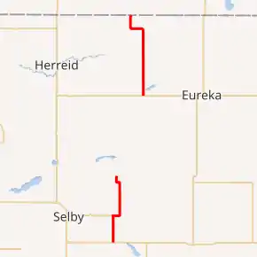
South Dakota Highway 271 (SD 271) is a 25.010-mile-long (40.250 km) state highway in the north-central part of the U.S. state of South Dakota. It connects portions of northeast Walworth County with the northeastern part of Campbell County.
| ||||
|---|---|---|---|---|
SD 271 highlighted in red | ||||
| Route information | ||||
| Maintained by SDDOT | ||||
| Length | 25.010 mi[1] (40.250 km) | |||
| Existed | c. 1975–present | |||
| Walworth County segment | ||||
| Length | 11.302 mi[1] (18.189 km) | |||
| South end | ||||
| Major junctions | ||||
| North end | 315th Avenue / 124th Street on the Walworth–Campbell county line northeast of Selby | |||
| Campbell County segment | ||||
| Length | 13.708 mi[1] (22.061 km) | |||
| South end | ||||
| North end | ||||
| Location | ||||
| Counties | Walworth, Campbell | |||
| Highway system | ||||
| ||||

It consists of two disconnected segments. The southern segment extends from U.S. Route 12 (US 12) south of Java to a rural intersection at the Walworth–Campbell county line, northeast of Selby. The northern segment begins at an intersection with SD 10 west of Eureka and ends at an intersection with 102nd Street at the North Dakota state line. Here, the roadway continues as 26th Avenue SE.
The northern segment was previously SD 105 prior to the mid-1970s.
Route description
Walworth County
SD 271's southern segment begins at an intersection with US 12 (134th Street) south of Java. Here, the roadway continues to the south as 314th Avenue. SD 271 heads due north on 314th Avenue and skirts along the western edge of Java. At an intersection with the eastern terminus of SD 130 (130th Street), SD 271 turns right onto 130th Street and travels to the east, while 314th Avenue continues to the north. SD 271 skirts along the northern edge of the town. At the northeastern edge of Java, it curves to the north, onto 315th Avenue, and continues to the north. Almost immediately, it crosses over some railroad tracks of BNSF Railway. The highway curves to the west, onto 125th Street, and then almost immediately back to the north on 315th Avenue. The highway continues to the north until it reaches the Campbell County. Here, this segment ends, the roadway intersects 124th Street, and continues to the north as 315th Avenue.
Campbell County
SD 271 resumes at an intersection with SD 10 (112th Street) west of Eureka. Here, the roadway continues as 319th Avenue to the south. SD 271 travels north on 319th Avenue and then crosses over Spring Creek just before traveling just to the east of Artas. It curves to the west onto 102nd Street and then back to the north on 317th Avenue. After a slight eastward bend, SD 271 reaches its northern terminus, an intersection with 102nd Street at the North Dakota state line. Here, the roadway continues to the north as 26th Avenue SE.
Major intersections
| County | Location | mi[1] | km | Destinations | Notes | ||
|---|---|---|---|---|---|---|---|
| Walworth | | 0.000 | 0.000 | Southern terminus; roadway continues as 314th Avenue | |||
| Java | 4.289 | 6.902 | Eastern terminus of SD 130; roadway continues as 314th Avenue | ||||
| Walworth–Campbell county line | | 11.302 | 18.189 | 124th Street / 315th Avenue north | Roadway continues as 315th Avenue | ||
| Gap in route | |||||||
| Campbell | | 15.307 | 24.634 | Roadway continues as 319th Avenue | |||
| | 25.010 | 40.250 | Northern terminus; continuation into North Dakota; roadway continues as 26th Avenue SE. | ||||
| 1.000 mi = 1.609 km; 1.000 km = 0.621 mi | |||||||
See also
 U.S. Roads portal
References
- "State Highway Log – Pierre Region" (PDF). South Dakota Department of Transportation. January 2017. p. 114. Retrieved January 18, 2018.