South Dakota Highway 407
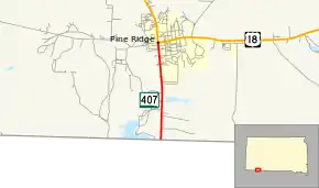
South Dakota Highway 407 (SD 407) is a 1.786-mile (2.874 km) state highway on the southern edge of Oglala Lakota County,[Note 1] South Dakota, United States. Along with Nebraska Highway 87 (N‑87), SD 407 serves as a connector route between U.S. Route 20 (US 20) in Rushville, Nebraska and U.S. Route 18 (US 18) in Pine Ridge.
| ||||
|---|---|---|---|---|
 | ||||
| Route information | ||||
| Maintained by SDDOT | ||||
| Length | 1.786 mi[1] (2.874 km) | |||
| Existed | 1975–present | |||
| Major junctions | ||||
| South end | ||||
| North end | ||||
| Location | ||||
| Counties | Oglala Lakota[Note 1] | |||
| Highway system | ||||
| ||||

Route description
SD 407 begins at the northern terminus of N‑87 (at 790 Road) on the Nebraska–South Dakota border, south of the community of Pine Ridge (a census-designated place [CDP]), and is entirely within the Pine Ridge Indian Reservation. (N‑87 continues southerly in Nebraska, through the CDP of White Clay, and on toward its southern terminus at US 20 in Rushville.)
From its southern terminus SD 407 heads north along the eastern edge of, and then into, Pine Ridge. A few blocks after entering the main part of the community SD 407 reaches its northern terminus at an intersection with US 18 and BIA Route 32 (BIA Rd. 32). From the northern terminus of SD 407, US 18 heads easterly to Martin and Mission and northerly to Oglala and Hot Springs. BIA Rd. 32 heads westerly to terminate at BIA Route 41.[3][4] On average, SD 407 is driven by over 4,200 vehicles per day.[1]
Major intersections
The entire route is in Oglala Lakota County. [4][Note 1]
| Location[4][Note 1] | mi[1] | km | Destinations | Notes | |
|---|---|---|---|---|---|
| White Clay | 0.000 | 0.000 | Continuation south into Nebraska from southern terminus | ||
| | Southern terminus of SD 407 | ||||
| Pine Ridge | 1.786 | 2.874 | Northern terminus of SD 407; eastern terminus of BIA Rd. 32 | ||
| Continuation north beyond northern terminus | |||||
| 1.000 mi = 1.609 km; 1.000 km = 0.621 mi | |||||
Notes
- Prior to 2015, Oglala Lakota County was known as Shannon County.[2]
References
- "Rapid City Region Highway Log" (PDF). dot.sd.gov. South Dakota Department of Transportation. 27 Feb 2019. p. 148. Retrieved 21 Oct 2019.
- "Oglala Lakota County, South Dakota". oglalalakota.sdcounties.org. Oglala Lakota County]]. Retrieved 22 Oct 2019.
- General Highway Map (Map). South Half Shannon County. South Dakota Department of Transportation. 2010. Retrieved 20 Dec 2011.
- Google (21 Oct 2019). "SD-407, West Oglala Lakota, SD 57770" (Map). Google Maps. Google. Retrieved 21 Oct 2019.
External links
| Wikimedia Commons has media related to South Dakota Highway 407. |