Martin, South Dakota
Martin (Lakota: pažóla otȟúŋwahe;[7] "Knoll City") is a city in Bennett County, South Dakota, United States. The population was 1,071 at the 2010 census. It is the county seat of Bennett County.[8]
Martin, South Dakota
pažóla otȟúŋwah | |
|---|---|
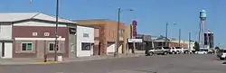 Downtown Martin: Main Street, looking northeast from 4th Avenue | |
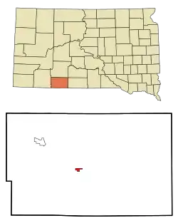 Location in Bennett County and the state of South Dakota | |
| Coordinates: 43°10′30″N 101°44′3″W | |
| Country | United States |
| State | South Dakota |
| County | Bennett |
| Founded | 1912[1] |
| Area | |
| • Total | 0.56 sq mi (1.45 km2) |
| • Land | 0.56 sq mi (1.45 km2) |
| • Water | 0.00 sq mi (0.00 km2) |
| Elevation | 3,310 ft (1,009 m) |
| Population | |
| • Total | 1,071 |
| • Estimate (2019)[4] | 1,045 |
| • Density | 1,862.75/sq mi (719.31/km2) |
| Time zone | UTC−7 (Mountain (MST)) |
| • Summer (DST) | UTC−6 (MDT) |
| ZIP code | 57551 |
| Area code(s) | 605 |
| FIPS code | 46-41100[5] |
| GNIS feature ID | 1256336[6] |
| Website | http://www.martinsd.net/ |
History
Martin was laid out in 1911.[9] The city was named for Eben Martin, a U.S. Representative from South Dakota.[10]
Geography
Martin is located at 43°10′30″N 101°44′3″W (43.174923, -101.734287).[11]
According to the United States Census Bureau, the city has a total area of 0.53 square miles (1.37 km2), all land.[12]
Martin has been assigned the ZIP code 57551 and the FIPS place code 41100.
Infrastructure
One of the highways that passes through Martin is U.S. Route 18, in an east–west direction. South Dakota Highway 73 runs north into the town and makes a T-intersection with U.S. 18. State Highway 73 turns into Hisle Road after the T-intersection.
Demographics
| Historical population | |||
|---|---|---|---|
| Census | Pop. | %± | |
| 1930 | 720 | — | |
| 1940 | 1,013 | 40.7% | |
| 1950 | 989 | −2.4% | |
| 1960 | 1,184 | 19.7% | |
| 1970 | 1,248 | 5.4% | |
| 1980 | 1,018 | −18.4% | |
| 1990 | 1,151 | 13.1% | |
| 2000 | 1,106 | −3.9% | |
| 2010 | 1,071 | −3.2% | |
| 2019 (est.) | 1,045 | [4] | −2.4% |
| U.S. Decennial Census[13] 2018 Estimate[14] | |||
2010 census
As of the census[3] of 2010, there were 1,071 people, 401 households, and 246 families living in the city. The population density was 2,020.8 inhabitants per square mile (780.2/km2). There were 467 housing units at an average density of 881.1 per square mile (340.2/km2). The racial makeup of the city was 41.6% White, 0.1% African American, 48.3% Native American, 1.2% Asian, 0.5% from other races, and 8.3% from two or more races. Hispanic or Latino of any race were 4.1% of the population.
There were 401 households, of which 37.9% had children under the age of 18 living with them, 34.7% were married couples living together, 19.2% had a female householder with no husband present, 7.5% had a male householder with no wife present, and 38.7% were non-families. 32.7% of all households were made up of individuals, and 15.7% had someone living alone who was 65 years of age or older. The average household size was 2.58 and the average family size was 3.26.
The median age in the city was 31.7 years. 30.4% of residents were under the age of 18; 11.4% were between the ages of 18 and 24; 20.8% were from 25 to 44; 21.6% were from 45 to 64; and 15.8% were 65 years of age or older. The gender makeup of the city was 46.8% male and 53.2% female.
2000 census
As of the census[5] of 2000, there were 1,106 people, 421 households, and 253 families living in the city. The population density was 1,210.5 people per square mile (469.3/km2). There were 480 housing units at an average density of 525.3 per square mile (203.7/km2). The racial makeup of the city was 53.98% White, 0.63% African American, 37.61% Native American, 0.09% Asian, 0.36% from other races, and 7.32% from two or more races. Hispanic or Latino of any race were 3.44% of the population.
There were 421 households, out of which 33.0% had children under the age of 18 living with them, 41.8% were married couples living together, 14.5% had a female householder with no husband present, and 39.7% were non-families. 35.6% of all households were made up of individuals, and 17.6% had someone living alone who was 65 years of age or older. The average household size was 2.51 and the average family size was 3.28.
In the city, the population was spread out, with 31.6% under the age of 18, 7.6% from 18 to 24, 23.1% from 25 to 44, 19.0% from 45 to 64, and 18.7% who were 65 years of age or older. The median age was 36 years. For every 100 females, there were 90.4 males. For every 100 females age 18 and over, there were 85.1 males.
As of 2000 the median income for a household in the city was $26,779, and the median income for a family was $32,500. Males had a median income of $26,964 versus $19,632 for females. The per capita income for the city was $13,752. About 19.0% of families and 24.9% of the population were below the poverty line, including 32.5% of those under age 18 and 14.2% of those age 65 or over.
Transportation
The only transportation for Martin is by road (U.S. 18, State Highway 73), or by air (Martin Municipal Airport).
References
- "SD Towns" (PDF). South Dakota State Historical Society. Archived from the original (PDF) on 2010-02-10. Retrieved 2010-02-14.
- "2019 U.S. Gazetteer Files". United States Census Bureau. Retrieved July 30, 2020.
- "U.S. Census website". United States Census Bureau. Retrieved 2012-06-21.
- "Population and Housing Unit Estimates". United States Census Bureau. May 24, 2020. Retrieved May 27, 2020.
- "U.S. Census website". United States Census Bureau. Retrieved 2008-01-31.
- "US Board on Geographic Names". United States Geological Survey. 2007-10-25. Retrieved 2008-01-31.
- Ullrich, Jan F. (2014). New Lakota Dictionary (2nd ed.). Bloomington, IN: Lakota Language Consortium. ISBN 978-0-9761082-9-0. Archived from the original on 2016-10-18. Retrieved 2014-02-13.
- "Find a County". National Association of Counties. Retrieved 2011-06-07.
- Federal Writers' Project (1940). South Dakota place-names, v.1-3. University of South Dakota. p. 50.
- "Profile for Martin, South Dakota". ePodunk. Archived from the original on 4 August 2016. Retrieved 4 June 2014.
- "US Gazetteer files: 2010, 2000, and 1990". United States Census Bureau. 2011-02-12. Retrieved 2011-04-23.
- "US Gazetteer files 2010". United States Census Bureau. Archived from the original on 2012-07-02. Retrieved 2012-06-21.
- United States Census Bureau. "Census of Population and Housing". Retrieved June 7, 2016.
Municipalities and communities of Bennett County, South Dakota, United States | ||
|---|---|---|
| City |  | |
| CDP | ||
| Unorganized territories |
| |
| Unincorporated communities | ||
| Indian reservation | ||
| Footnotes | ‡This populated place also has portions in an adjacent county or counties | |
| ||
| Authority control |
|
|---|