St. John's Group
The St John's Group is a fossiliferous shale-dominated Ediacaran geologic group in Newfoundland and Labrador, younger than 565 ± 3 million years ago.[1]
| St John's Group Stratigraphic range: Ediacaran [1] (post-565 Ma) | |
|---|---|
| Type | Group |
| Sub-units | [2]
|
| Underlies | Signal Hill Group[3] |
| Overlies | Conception Group[3] |
| Lithology | |
| Primary | Shale[4] |
| Location | |
| Region | Newfoundland and Labrador |
| Country | Canada |
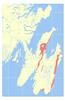
 Occurrence of St. John's Group in the bedrock of Newfoundland | |
It corresponds to the upper portion of the Connecting Point Group [5]
References
- Various Contributors to the Paleobiology Database. "Fossilworks: Gateway to the Paleobiology Database". Archived from the original on 31 July 2014. Retrieved 8 July 2014.
- Myrow, P (1995). "Neoproterozoic rocks of the Newfoundland Avalon Zone". Precambrian Research. 73 (1–4): 123–136. Bibcode:1995PreR...73..123M. doi:10.1016/0301-9268(94)00074-2.
- (PDF) http://www.nr.gov.nl.ca/nr/mines/geoscience/publications/currentresearch/2005/obrien.pdf. Cite journal requires
|journal=(help); Missing or empty|title=(help) - A.G. Liu; D. McIlroy (September 2014). "Horizontal Surface Traces from the Fermeuse Formation, Ferryland (Newfoundland, Canada), and their Place within the Late Ediacaran Ichnological Revolution" (PDF). Geological Association of Canada - Special Paper (9).
- http://www.flr.gov.nl.ca/publications/parks/fortune_head_ecological_reserve.pdf
- Geology compiled by A. F. King Map series edited by S. P. Colman-Sadd and J. P. Hayes, GEOLOGY OF THE AVALON PENINSULA, NEWFOUNDLAND (parts of 1K, 1L, 1M, 1N and 2C) Map 88-01 (Digital reproduction) (PDF)
This article is issued from Wikipedia. The text is licensed under Creative Commons - Attribution - Sharealike. Additional terms may apply for the media files.