St. Paul, Arkansas
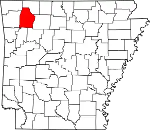
St. Paul is a town in southern Madison County, Arkansas, United States. The population was 113 at the 2010 census. It is on the edge of the Northwest Arkansas region.
St. Paul, Arkansas | |
|---|---|
 St. Paul post office | |
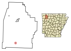
 Location of St. Paul in Madison County, Arkansas. | |
| Coordinates: 35°49′27″N 93°45′51″W | |
| Country | United States |
| State | Arkansas |
| County | Madison |
| Government | |
| • Mayor | Nina Selz[1] |
| Area | |
| • Total | 0.46 sq mi (1.18 km2) |
| • Land | 0.45 sq mi (1.18 km2) |
| • Water | 0.00 sq mi (0.00 km2) |
| Elevation | 1,516 ft (462 m) |
| Population (2010) | |
| • Total | 113 |
| • Estimate (2019)[3] | 113 |
| • Density | 248.90/sq mi (96.08/km2) |
| Time zone | UTC-6 (Central (CST)) |
| • Summer (DST) | UTC-5 (CDT) |
| FIPS code | 05-62060 |
| GNIS feature ID | 0073457 |
St. Paul was platted in 1887 when the railroad was extended to that point.[4]
Geography
St. Paul is located at 35°49′27″N 93°45′51″W (35.8242459, -93.7640813).[5] According to the United States Census Bureau, the town has a total area of 0.7 km2 (0.3 mi2), all land.[6]
The community is located along the Highway 23 and Highway 16 concurrency on the upper White River. The north boundary of the Ozark-St. Francis National Forest is adjacent to the south side of the community.[7]
Ecoregion
The city is located in the Upper Boston Mountain ecoregion. The Upper Boston Mountains ecoregion is generally higher and moister than the Lower Boston Mountains; elevations vary from 1,900 to 2,800 feet. Potential natural vegetation is oak–hickory forest. Characteristically, the forests of the Upper Boston Mountains are more closed and contain far less pine than those of the Lower Boston Mountains. North-facing slopes support mesic forests. The region is underlain by Pennsylvanian sandstone, shale and siltstone that contrasts with the limestone and dolomite that dominates the Ozark Highlands. Water quality in streams reflects geology, soils, and land use, and is typically exceptional; mineral, nutrient, and solid concentrations as well as turbidity all tend to be very low. During the summer, many streams do not flow.[8]
Demographics
| Historical population | |||
|---|---|---|---|
| Census | Pop. | %± | |
| 1890 | 417 | — | |
| 1900 | 345 | −17.3% | |
| 1910 | 430 | 24.6% | |
| 1920 | 284 | −34.0% | |
| 1930 | 198 | −30.3% | |
| 1940 | 211 | 6.6% | |
| 1950 | 136 | −35.5% | |
| 1960 | 118 | −13.2% | |
| 1970 | 145 | 22.9% | |
| 1980 | 198 | 36.6% | |
| 1990 | 88 | −55.6% | |
| 2000 | 163 | 85.2% | |
| 2010 | 113 | −30.7% | |
| 2019 (est.) | 113 | [3] | 0.0% |
| U.S. Decennial Census[9] | |||
As of the census[10] of 2000, there were 163 people, 70 households, and 44 families residing in the town. The population density was 242.1/km2 (623.1/mi2). There were 79 housing units at an average density of 117.3/km2 (302.0/mi2). The racial makeup of the town was 100.00% White. 4.29% of the population were Hispanic or Latino of any race.
There were 70 households, out of which 25.7% had children under the age of 18 living with them, 50.0% were married couples living together, 10.0% had a female householder with no husband present, and 37.1% were non-families. 28.6% of all households were made up of individuals, and 18.6% had someone living alone who was 65 years of age or older. The average household size was 2.33 and the average family size was 2.95.
In the town, the population was spread out, with 22.1% under the age of 18, 7.4% from 18 to 24, 27.0% from 25 to 44, 26.4% from 45 to 64, and 17.2% who were 65 years of age or older. The median age was 40 years. For every 100 females, there were 94.0 males. For every 100 females age 18 and over, there were 104.8 males.
The median income for a household in the town was $25,625, and the median income for a family was $26,250. Males had a median income of $18,958 versus $15,500 for females. The per capita income for the town was $11,865. About 12.5% of families and 16.9% of the population were below the poverty line, including 32.4% of those under the age of eighteen and 12.5% of those 65 or over.
Education
Public education for students in kindergarten through grade 12 is provided by the Huntsville School District, which leads to graduation at St. Paul High School.
On July 1, 2004, the St. Paul School District was merged into the Huntsville School District.[11]
References
- https://local.arkansas.gov/local.php?agency=St.%20Paul
- "2019 U.S. Gazetteer Files". United States Census Bureau. Retrieved June 30, 2020.
- "Population and Housing Unit Estimates". United States Census Bureau. May 24, 2020. Retrieved May 27, 2020.
- History of Benton, Washington, Carroll, Madison, Crawford, Franklin, and Sebastian Counties, Arkansas. Higginson Book Company. 1889. p. 460.
- U.S. Geological Survey Geographic Names Information System: St. Paul, Arkansas
- "2017 U.S. Gazetteer Files". United States Census Bureau. Retrieved Aug 22, 2018.
- Arkansas Atlas and Gazetteer (Map) (Second ed.). DeLorme. 2002. p. 31. ISBN 0-89933-345-1.
-
 This article incorporates public domain material from the United States Geological Survey document: Woods, AJ; Foti, TL; Chapman, SS; Omernik, JM; et al. "Ecoregions of Arkansas" (PDF). (color poster with map, descriptive text, summary tables, and photographs)
 - "Census of Population and Housing". Census.gov. Retrieved June 4, 2015.
- "U.S. Census website". United States Census Bureau. Retrieved 2008-01-31.
- "Consolidation/Annexations of LEA's (1983-2010)." () Arkansas Department of Education. Retrieved on March 6, 2011.

