State Line, Franklin County, Pennsylvania
State Line is an unincorporated community and census-designated place (CDP) in Antrim Township, Franklin County, Pennsylvania, United States. It is next to the Maryland state line along Interstate 81 and U.S. Route 11 between Hagerstown, Maryland, and Greencastle, Pennsylvania. As of the 2010 census the population was 2,709.[1]
State Line, Franklin County, Pennsylvania | |
|---|---|
 State Line  State Line | |
| Coordinates: 39°43′21″N 77°43′27″W | |
| Country | United States |
| State | Pennsylvania |
| County | Franklin |
| Township | Antrim |
| Elevation | 710 ft (220 m) |
| Population (2010) | |
| • Total | 2,709 |
| • Density | 989/sq mi (382.0/km2) |
| Time zone | UTC-5 (Eastern (EST)) |
| • Summer (DST) | UTC-4 (EDT) |
| ZIP code | 17263 |
| Area code(s) | 717 |
| FIPS code | 42-73848 |
| GNIS feature ID | 1217375 |
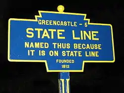
State Line was originally called Middleburg, and under the latter name laid out in 1812, and named for its location between Greencastle and Hagerstown, Maryland.[2] The present name comes from the fact the community is located on the Maryland-Pennsylvania state line.[2] A post office called State Line was established in 1830.[3]
References
- "Geographic Identifiers: 2010 Census Summary File 1 (G001), State Line CDP, Pennsylvania". American FactFinder. U.S. Census Bureau. Archived from the original on February 13, 2020. Retrieved August 12, 2016.
- M'Cauley, I. H. (1878). Historical Sketch of Franklin County, Pennsylvania. Patriot. p. 214.
- "Franklin County". Jim Forte Postal History. Retrieved 19 June 2017.
External links
| Wikimedia Commons has media related to State Line, Franklin County, Pennsylvania. |
Municipalities and communities of Franklin County, Pennsylvania, United States | ||
|---|---|---|
| Boroughs | 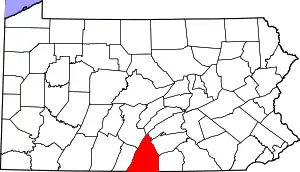 | |
| Townships | ||
| CDPs | ||
| Unincorporated communities |
| |
| Footnotes | ‡This populated place also has portions in an adjacent county or counties | |
| ||
This article is issued from Wikipedia. The text is licensed under Creative Commons - Attribution - Sharealike. Additional terms may apply for the media files.
