Stockhorn
The Stockhorn is a mountain of the Bernese Alps, overlooking the region of Lake Thun in the Bernese Oberland. It is located north of the town of Erlenbach im Simmental.
| Stockhorn | |
|---|---|
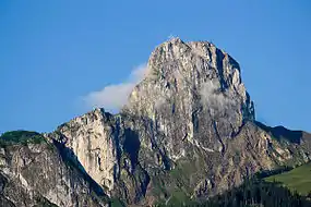 North side | |
| Highest point | |
| Elevation | 2,190 m (7,190 ft) |
| Prominence | 399 m (1,309 ft) [1] |
| Parent peak | Schafberg |
| Isolation | 9.1 km (5.7 mi) [2] |
| Coordinates | 46°41′38″N 7°32′15″E |
| Geography | |
 Stockhorn Location in Switzerland | |
| Location | Bern, Switzerland |
| Parent range | Bernese Alps |
| Climbing | |
| Easiest route | Cable car |
The Stockhorn is 2,190 m (7,190 ft) high and is accessible via cable car from Erlenbach. It has a restaurant at the top and is a good starting point for many hikes. There is good fishing in the two lakes right below the Stockhorn, the Oberstockensee (around 1,650 m [5,410 ft] high) and the Hinterstockensee (around 1,550 m [5,090 ft] high). There is a subterranean water connection between the two lakes.
From the top the view includes many of the surrounding Alps; the Eiger, Mönch, Jungfrau, Schreckhorn, along with the valley of the Aare river, Thun and Lake Thun, Interlaken and the Jura Mountains.
References
- Retrieved from the Swisstopo topographic maps. The key col is the Chänelpass (1,791 m).
- Retrieved from Google Earth. The nearest point of higher elevation is northwest of the Drunengalm.
