Stogursey
Stogursey is the name of a small village and civil parish in the Quantock Hills in Somerset, England. It is situated 3 miles (4.8 km) from Nether Stowey, and 8 miles (12.9 km) west of Bridgwater. The village is situated near the Bristol Channel, which bounds the parish on the north.
| Stogursey | |
|---|---|
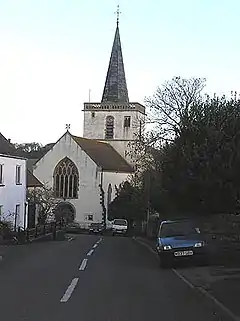
 Church of St Andrew | |
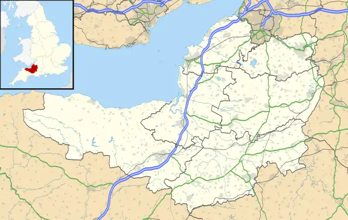
 Stogursey Location within Somerset | |
| Population | 1,385 (2011)[1] |
| OS grid reference | ST203430 |
| District | |
| Shire county | |
| Region | |
| Country | England |
| Sovereign state | United Kingdom |
| Post town | Bridgwater |
| Postcode district | TA5 |
| Dialling code | 01278 |
| Police | Avon and Somerset |
| Fire | Devon and Somerset |
| Ambulance | South Western |
| UK Parliament | |
The parish includes the village of Stolford, which is believed to mean 'The stile ford' from the Old English stigol and ford,[2] and the hamlets of Burton, Knighton, Shurton, Stoford, Week, and Fairfield.
History
On the beach near Stogursey are the remains of a submerged forest dated to 2500 B.C.[3]
A Romano-British coin hoard was discovered in 1999. It contained 1,097 base silver radiates, the remains of a pottery vessel and 50 copper alloy coins.[4][5]
It takes its name from the manor of Stoke. Medieval Stoche was in the possession of William de Falaise by 1086,[6] who had recently married Geva, daughter of Serlo de Burci, and widow of Martin "de Wallis". Early in the 12th century, William and Geva's daughter, Emma, was betrothed to William de Courcy, and the couple received the manor of Stoke upon their wedding. The manor was renamed Stoke Courcy, and is now known as Stogursey. Stogursey Castle was probably built in the 12th century.[7]
The best-known member of the family was John de Courcy, who made himself virtual Prince of Ulster after conquering it in 1177. He died about 1219, his descendants (all illegitimate) today being the Baron Kingsale of Ireland.
During the reign of King John of England (1199–1216) it became the property of one of his favourites and closest advisors, Fulke de Breauté of Gascony. Fulke's sister, Avice de Breauté, was mother of Sir Nicholas FitzMartin (c. 1210–82), who, like the de Courcys, was a descendant of Geva de Burci, the wife of William de Falaise, via her son Robert FitzMartin. Said to be tyrannical, Fulke made the castle and village a stronghold and den of robbers; he was eventually expelled in the reign of Henry III, and is said to have died in poverty in Normandy after 1224.
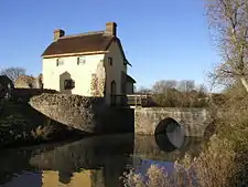
Part of a curtain wall from the castle remains incorporated into a cottage. It is a Grade II* listed building and Scheduled Ancient Monument.[8]
The remains of a Ham stone village cross on the High Street is from the Middle Ages. Approximately 1 metre (3 ft 3 in) of the original shaft is still in the socket stone.[9][10]
In the Middle Ages Stogursey was an important place. It became a borough by 1225, and retained that status until at least 1833.[7] Stogursey was part of the hundred of Cannington.[11]
The ancient parish of Stogursey was large. It included the north foreshore of the Steart Peninsula, including Stert Island which broke from the mainland in about 1798. In 1885 Stert Island was transferred to the parish of Huntspill, and in 1933 the north side of the Steart Peninsula was transferred to the parish of Otterhampton.[7]
Wick Barrow, near Stogursey, is associated with pixies. It is said that a ploughman working nearby once mended a pixie's broken peel, and the pixie baked a cake to reward him.[12]
Governance
The parish council has responsibility for local issues, including setting an annual precept (local rate) to cover the council's operating costs and producing annual accounts for public scrutiny. The parish council evaluates local planning applications and works with the local police, district council officers, and neighbourhood watch groups on matters of crime, security, and traffic. The parish council's role also includes initiating projects for the maintenance and repair of parish facilities, as well as consulting with the district council on the maintenance, repair, and improvement of highways, drainage, footpaths, public transport, and street cleaning. Conservation matters (including trees and listed buildings) and environmental issues are also the responsibility of the council.
The village falls within the non-metropolitan district of Somerset West and Taunton, which was established on 1 April 2019. It was previously in the district of West Somerset, which was formed on 1 April 1974 under the Local Government Act 1972, and part of Williton Rural District before that.[13] The district council is responsible for local planning and building control, local roads, council housing, environmental health, markets and fairs, refuse collection and recycling, cemeteries and crematoria, leisure services, parks, and tourism.
Somerset County Council is responsible for running the largest and most expensive local services such as education, social services, libraries, main roads, public transport, policing and fire services, trading standards, waste disposal and strategic planning.
The appropriate electoral ward is called 'Quantock Vale'. The ward stretches along the Bristol Channel from Kilve via Stogursey to Stolford. The total ward population at the 2011 Census is 2,121.[14]
It is also part of the Bridgwater and West Somerset county constituency represented in the House of Commons of the Parliament of the United Kingdom. It elects one Member of Parliament (MP) by the first past the post system of election.
Religious sites
Within the village, at the bottom of the street, stands the church of St Andrew, built early in the 12th century by William de Falaise, though believed to incorporate earlier features.[15] However, some of this may be due to the workers being English, not Norman; and the fact that in the 1940s Reverend Basil Tucker removed much of the Victorian era work, giving the church its original, sparse yet pleasing shape.
Less than a quarter of a mile to the south are the restored remains of Stogursey Castle.[16]
A priory in the village was built by the Falaise family. To preserve the family's association with Normandy the priory was donated as a cell to the Benedictine Abbey of St Mary at Lonlay. This dwindled over the years and when all alien priories were appropriated by the crown in the 15th century Henry VI presented the endowments of Stogursey to "the College of the Blessed Mary of Eton beside Windsor" (Eton College), which he had founded a few years earlier.[17]
Notable residents
In 1863 Neville Howse was born in the village. He went on to join the Australian army and was the first Australian to be awarded the Victoria Cross.
Haile Selassie, the emperor of Abyssinia, visited Stogursey in 1938.
References
- "Statistics for Wards, LSOAs and Parishes — SUMMARY Profiles" (Excel). Somerset Intelligence. Retrieved 4 January 2014.
- Robinson, Stephen (1992). Somerset Place Names. Dovecote Press. ISBN 1-874336-03-2.
- "Stogursey". Victoria County History. British History Online. Retrieved 14 November 2008.
- Bland, Roger, ed. (2000). Treasure Annual Report 1998 - 1999 (PDF). Department for Culture, Media and Sport. Archived from the original (PDF) on 1 March 2012.CS1 maint: ref=harv (link)
- Bland, Roger; Voden-Decker, Lisa, eds. (2002). Treasure Annual Report 2000 (PDF). Department for Culture, Media and Sport. Archived from the original (PDF) on 1 March 2012.CS1 maint: ref=harv (link)
- Open Domesday Online: Stogursey
- A P Baggs and M C Siraut (1992). "Stogursey". A History of the County of Somerset: Volume 6. Victoria County History. pp. 130–136. Retrieved 25 January 2015.CS1 maint: uses authors parameter (link)
- "Stogursey Castle". Listed Buildings Online. English Heritage. Retrieved 2 January 2011.
- Historic England. "Village cross 75m north of St Andrew's Well (1019034)". National Heritage List for England. Retrieved 23 January 2015.
- Historic England. "Remains of Village cross (1345701)". National Heritage List for England. Retrieved 23 January 2015.
- "Cannington Hundred". British History Online. Retrieved 23 September 2011.
- Ash, Russell (1973). Folklore, Myths and Legends of Britain. Reader's Digest Association Limited. p. 165. ISBN 9780340165973.
- "Williton RD". A vision of Britain Through Time. University of Portsmouth. Retrieved 5 January 2014.
- "Quantock Vale ward 2011". Retrieved 2 March 2015.
- Historic England. "Church of St Andrew (1057404)". National Heritage List for England. Retrieved 11 March 2008.
- Historic England. "Stogursey Castle (1057403)". National Heritage List for England. Retrieved 11 March 2008.
- Waite, Vincent (1964). Portrait of the Quantocks. London: Robert Hale. ISBN 0-7091-1158-4.
External links
| Wikimedia Commons has media related to Stogursey. |


