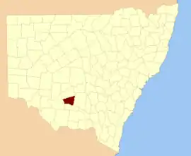
Sturt County

Sturt County is one of the 141 Cadastral divisions of New South Wales. It contains the locality of Carrathool. The Murrumbidgee River is the southern boundary.

Sturt
New South Wales
Location in New South Wales
Lands administrative divisions around Sturt:
Nicholson Nicholson Cooper
Waradgery Sturt Cooper
Waradgery Boyd Boyd
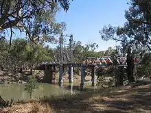
The Carathool Bridge over the Murrumbidgee between Sturt and Boyd
Sturt County NSW as shown on John Sands 1886 map)[1]

Sturt County was named in honour of the explorer, soldier and public servant Charles Sturt (1795-1869).[2]

Parishes within this county

A full list of parishes found within this county; their current LGA and mapping coordinates to the approximate centre of each location is as follows:

ParishLGACoordinates
AlleyneCarrathool Shire Council34°18′54″S 145°28′04″E
BaillieCity of Griffith34°22′54″S 145°55′04″E
BallingallCity of Griffith34°13′54″S 146°00′04″E
BeabulaHay Shire Council34°13′54″S 145°11′04″E
BendigoCity of Griffith34°21′54″S 145°47′04″E
BenerembahCarrathool Shire Council34°28′54″S 145°55′04″E
BringageeCarrathool Shire Council34°25′54″S 145°45′04″E
BuckleyCarrathool Shire Council34°09′54″S 145°29′04″E
CajalduraCarrathool Shire Council34°23′54″S 145°34′04″E
CarrathoolCarrathool Shire Council34°22′54″S 145°30′04″E
CarregoCarrathool Shire Council34°05′54″S 145°28′04″E
CockburnCarrathool Shire Council34°08′54″S 145°44′04″E
DennyCarrathool Shire Council34°02′54″S 145°51′04″E
DjallahCity of Griffith34°23′54″S 145°51′04″E
DowneyHay Shire Council34°11′54″S 145°09′04″E
ErcildouneCarrathool Shire Council34°18′54″S 145°35′04″E
HerveyCarrathool Shire Council34°10′54″S 145°42′04″E
HoulongCarrathool Shire Council34°21′54″S 145°23′04″E
Hyde ParkCarrathool Shire Council34°18′54″S 145°41′04″E
KoobaCarrathool Shire Council34°04′54″S 146°00′04″E
KooroongalCarrathool Shire Council34°23′54″S 145°40′04″E
LearmonthCity of Griffith34°15′54″S 145°48′04″E
LethingtonCarrathool Shire Council34°11′54″S 145°26′04″E
LivingstoneCarrathool Shire Council34°05′54″S 145°37′04″E
MaidenCarrathool Shire Council34°02′54″S 145°43′04″E
MairCarrathool Shire Council34°10′54″S 145°37′04″E
MillsCarrathool Shire Council34°07′54″S 145°19′04″E
MirroolCity of Griffith34°08′54″S 146°02′04″E
MunroCarrathool Shire Council34°02′54″S 145°55′04″E
North BringageeCity of Griffith34°09′54″S 145°49′04″E
North UardryCarrathool Shire Council34°12′54″S 145°19′04″E
O'BrienCity of Griffith33°59′54″S 145°53′04″E
QuambatookCarrathool Shire Council34°14′54″S 145°36′04″E
TabbitaCarrathool Shire Council33°54′54″S 146°02′04″E
TabbitaCarrathool Shire Council33°56′54″S 145°57′04″E
TerrapeeCarrathool Shire Council34°13′54″S 145°31′04″E
Toms PointCarrathool Shire Council34°29′54″S 145°14′04″E
UardryCarrathool Shire Council34°20′54″S 145°18′04″E
WarburnCity of Griffith34°16′54″S 145°53′04″E
WiveonCarrathool Shire Council34°14′54″S 145°42′04″E
WowongCarrathool Shire Council34°28′54″S 145°50′04″E
WycheproofCarrathool Shire Council34°04′54″S 145°32′04″E
YannawayCarrathool Shire Council34°13′54″S 145°25′04″E

References

  1. The New atlas of Australia (John Sands 1886) map 21.
  2. "Sturt County". Geographical Names Register (GNR) of NSW. Geographical Names Board of New South Wales.
This article is issued from Wikipedia. The text is licensed under Creative Commons - Attribution - Sharealike. Additional terms may apply for the media files.