Sulphur River
The Sulphur River is a 175-mile-long (282 km)[1] river in northeast Texas and southwest Arkansas in the United States.
| Sulphur River | |
|---|---|
| Location | |
| Country | United States |
| States | Texas, Arkansas |
| Physical characteristics | |
| Source | |
| • location | Confluence of north and south forks at |
| • coordinates | 33°23′27″N 95°21′23″W |
| • elevation | 333 feet (101 m) |
| Mouth | |
• location | Red River at |
• coordinates | 33°05′23″N 93°51′33″W |
• elevation | 175 feet (53 m) |
| Length | 175 miles (282 km) |
Geography
The Sulphur River begins at the confluence of its north and south forks along the Delta–Lamar county line. This merger is about 4.7 miles (7.6 km) northeast of the town of Sulphur Bluff, 95 miles (153 km) northeast of Dallas, and 16 miles (26 km) downstream from the Cooper Lake dam.
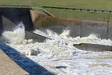
The river flows generally eastward through several Texas counties and provides most of the water for Wright Patman Lake, on the border between Bowie and Cass counties. Below Wright Patman Dam, the river continues its generally eastward flow to the Arkansas state line. The river flows southeastward through Miller County in southwestern Arkansas for 15 miles (24 km) until it joins the southbound Red River east of Doddridge, a few miles above the Louisiana border.

Recreation
The Sulphur River provides numerous opportunities for fishing, boating, and other activities.
Above Wright Patman Lake, the river has enough water for recreation most of the time. The flow is slow, and the river is murky, largely due to channelization upstream. Below Wright Patman Dam, the river flow depends on the amount of water being released from the dam; however, water quality is usually good.
Wright Patman Lake provides additional opportunities for camping, boating, swimming, and fishing.
See also
References
- "The National Map". U.S. Geological Survey. Retrieved March 8, 2011.
External links
- Sulphur River Basin Authority
- Texas Parks and Wildlife Department: An Analysis of Texas Waterways
- Sulphur River from the Handbook of Texas Online
| Authority control |
|---|