Suntar-Khayata Range
Suntar-Khayata Range (Russian: Сунтар-Хаята, Yakut: Сунтаар Хайата) is a granite mountain range rising along border of Sakha Republic in the north with Amur Oblast and Khabarovsk Krai in the south.
| Suntar-Khayata Range | |
|---|---|
| Сунтар-Хаята | |
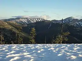 View of the range in June | |
| Highest point | |
| Peak | Mus-Khaya |
| Elevation | 2,959 m (9,708 ft) |
| Geography | |
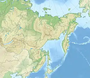 Location in the Far Eastern Federal District, Russia | |
| Country | Russia |
| Region | Sakha/Khabarovsk Krai |
| Range coordinates | 62°36′00″N 140°53′00″E |
| Parent range | East Siberian System |
| Geology | |
| Orogeny | Alpine orogeny |
| Age of rock | Late Jurassic |
| Type of rock | Volcanic rocks, granite |
The R504 Kolyma Highway passes through the northern part of the range by Kyubeme.[1]
Geography
The Suntar-Khayata Range is a watershed divide between the Aldan River, which eventually flows into the Lena River and the Arctic Ocean, and the Sea of Okhotsk. It contains the southernmost glaciers in the Russian Far East outside of Kamchatka,[2] though its status is not known. The range is approximately 450–550 km long and 60 km wide.[3][4] 2,959 metres (9,708 ft) high Mus-Khaya Mountain, located in the Sakha Republic, is the highest point of the range.[3] Berill Mountain, at 2,933 metres (9,623 ft) is the highest summit in Khabarovsk Krai. Hakandya is an ultra-prominent peak that is 2,615 metres (8,579 ft) high.[5]
The Suntar-Khayata Range is geographically a southeastern prolongation of the Verkhoyansk Range. Until mid 20th century it was treated as a separate range, together with the Skalisty Range, highest point 2,017 metres (6,617 ft), and the Sette Daban, highest point 2,017 metres (6,617 ft), to the southwest. The Yudoma-Maya Highlands are located to the south of the range.[6]
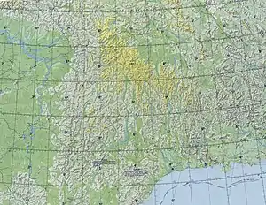 Sette-Daban and Suntar-Khayata map section. |
Subranges
The Suntar-Khayata system comprises a number of subranges,[7] including:
- Chelat Range
- Net-Taga Range
- Yudom Range
- Kukhtur Range
Geology
The strata of this geological formation date back to the Late Jurassic. Dinosaur remains are among the fossils that have been recovered from the formation.[8]
Flora and fauna
The higher slopes of the range are sparsely wooded, with mainly larch forests and tundra.
A small population of Brown Dippers (Cinclus pallasi) winters at a hot spring in the Suntar-Khayata Range. The birds feed underwater when air temperatures drop below −55 °C (−67 °F).[9]
Vertebrate paleofauna
Indeterminate Carnosauria remains, possible indeterminate Coelurosaur remains, indeterminate Sauropoda remains that had been previously referred to Camarasauridae indet, and indeterminate Theropoda remains have all been recovered from Suntar outcrops in Sakha Republic, Russia.[8]
| Dinosaurs of the Suntar Series | ||||
|---|---|---|---|---|
| Genus | Species | Presence | Notes | Images |
|
cf. Stegosaurus sp.[8] |
Sakha Republic, Russia.[8] |
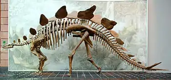 A specimen of Stegosaurus. | ||
See also
Notes
- ТРРС 3 / 104А. Описание местности (in Russian)
- DMGN. Suntar-Khayata
- Сунтар-Хаята, Great Soviet Encyclopedia
- Siberia, 26 Mountain Summits with Prominence of 1,500 meters or greater
- Verkhoyansk Range // Great Soviet Encyclopedia: [in 30 vols.] / Ch. ed. A.M. Prokhorov. - 3rd ed. - M. Soviet Encyclopedia, 1969-1978.
- Oleg Leonidovič Kryžanovskij, A Checklist of the Ground-beetles of Russia and Adjacent Lands. p. 16
- Weishampel, David B; et al. (2004). "Dinosaur distribution (Late Jurassic, Asia)." In: Weishampel, David B.; Dodson, Peter; and Osmólska, Halszka (eds.): The Dinosauria, 2nd, Berkeley: University of California Press. Pp. 550–552. ISBN 0-520-24209-2.
- Dinets, V.; Sanchez, M. (2017). "Brown Dippers (Cinclus pallasi) overwintering at −65°C in Northeastern Siberia". Wilson Journal of Ornithology. 129 (2): 397–400. doi:10.1676/16-071.1. S2CID 91058122.