Surgana
Surgana is a census town and taluka in Nashik District in the Indian state of Maharashtra.
Surgana | |
|---|---|
census town | |
 Surgana Location in Maharashtra, India | |
| Coordinates: 20.57°N 73.62°E | |
| Country | |
| State | Maharashtra |
| District | Nashik |
| Elevation | 533 m (1,749 ft) |
| Population (2001) | |
| • Total | 6,144 |
| Languages | |
| • Official | Marathi |
| Time zone | UTC+5:30 (IST) |
| ISO 3166 code | IN-MH |
| Website | maharashtra |
History
During the British Raj era, Surgana State was one of several princely states governed by the Pawar dynasty of Kolis. It was the only state of the Nasik Agency.[1][2][3]
Geography
Surgana is located at 20.57°N 73.62°E.[4] It has an average elevation of 533 metres (1748 feet). It is about 90 km from Nashik.
Demographics
In the 2001 India census, Surgana had a population of 6,147.[5] Males constituted 54% of the population and females 46%. Surgana had an average literacy rate of 70%, higher than the national average of 59.5%: male literacy was 75%, and female literacy was 64%. In 2001 in Surgana, 13% of the population was under 6 years of age.[6]
References
- "GAZETTEERs OF BOMBAY PRESIDENCY - KHANDESH". Maharashtra.gov.in. Maharashtra Government Gazetteers Department. Retrieved 5 February 2018.
- Great Britain. India Office. "Great Britain. India Office. Imperial gazetteer of India .. (Volume 23) online. (page 20 of 52)". Retrieved 5 February 2018 – via ebooksread.com.
- Gazetteer of the Bombay Presidency: Khándesh. Government Central Press. 1880. p. 612. Retrieved 5 February 2018.
- "Surgana, India Page". FallingRain.com. 27 August 2016. Retrieved 5 February 2018.
- "Census 2001 Population Finder: Maharashtra: Town: Surgana (C.T.)". Office of The Registrar General & Census Commissioner, Ministry of Home Affairs, Government of India.
- "Census of India 2001: Data from the 2001 Census, including cities, villages and towns (Provisional)". Census Commission of India. Archived from the original on 16 June 2004. Retrieved 1 November 2008.
Nashik district topics | ||
|---|---|---|
| Rivers and lakes | 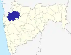 | |
| Cities and towns | ||
| Monuments |
| |
| Education | ||
| Lok Sabha constituencies | ||
| Vidhan Sabha constituencies | ||
| Major Highways | ||
This article is issued from Wikipedia. The text is licensed under Creative Commons - Attribution - Sharealike. Additional terms may apply for the media files.