Sutjeska (river)
The Sutjeska (Serbian Cyrillic: Сутјеска; pronounced [sûtjɛska]) is a 35 km-long river in eastern Bosnia and Herzegovina. It is a tributary of the Drina river, which it meets south of Foča. The literal meaning of "sutjeska" is "gorge, canyon".
| Sutjeska | |
|---|---|
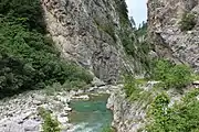 Sutjeska River - before entering Sutjeska River canyon | |
| Location | |
| Country | Bosnia and Herzegovina |
| Physical characteristics | |
| Mouth | |
• location | Drina |
• coordinates | 43.3736°N 18.7944°E |
| Basin features | |
| Progression | Drina→ Sava→ Danube→ Black Sea |
Geography
The Sutjeska River could be considered main river basin largely located within Sutjeska National Park itself. The Sutjeska divides Zelengora Mountain from Maglić, Volujak and Bioč mountains, and has carved impressive canyon 3,936 feet (1,200 m) deep, and Tjentište valley through the middle of the park.[1][2]
Tributaries
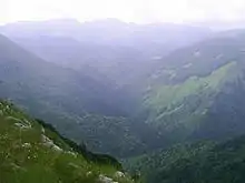
Hrčavka River valley, tributary of the Sutjeska within Sutjeska National Park
Tributaries of the Sutjeska are:
- left tributaries are Klobučarica Creek, Jabučnica Creek, and Hrčavka River;
- right tributaries are Suški Creek (also called Suha River or Creek Sušica), Prijevor Creek and Perućica Creek.
Historical significance
It is famous for having been the site of the World War II Battle of the Sutjeska.
See also
References
- "Maglic". Encyclopædia Britannica. Retrieved 17 July 2011.
- "2012 'Summit for Danny' Bosnia & Herzegovina Climb Mount Maglic, Bosnia's Highest Peak, in Support of the Daniel Bryant Youth & Family Treatment Center" (PDF). Day 5, 7 September ~ Sutjeska National Park. Cadasb.org. pp. 7–9. Retrieved 16 July 2011.
| Wikimedia Commons has media related to Sutjeska River. |
This article is issued from Wikipedia. The text is licensed under Creative Commons - Attribution - Sharealike. Additional terms may apply for the media files.