Swanport, South Australia
Swanport, also formerly known as Thompson's Crossing and Thomson's Landing, is a suburban satellite locality of Murray Bridge in South Australia on the west (right) bank of the Murray River adjacent to Swanport Bridge.[1] Its boundaries were formalised in March 2000 to cover a portion of semi-urban land immediately south of the South Eastern Freeway adjacent to the Swanport Bridge, which is the main road freight route over the Murray.[1] It is named for the docking place on the west bank of the Murray which was home to "numerous swans"[1] and also known as Thomson's Landing.[2]
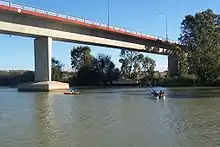
Swanport Bridge at the northern edge of the locality
| Swanport South Australia | |||||||||||||||
|---|---|---|---|---|---|---|---|---|---|---|---|---|---|---|---|
 Swanport | |||||||||||||||
| Coordinates | 35.153°S 139.312°E | ||||||||||||||
| Postcode(s) | 5253 | ||||||||||||||
| LGA(s) | Rural City of Murray Bridge | ||||||||||||||
| State electorate(s) | Hammond | ||||||||||||||
| Federal Division(s) | Barker | ||||||||||||||
| |||||||||||||||
| Footnotes | Coordinates[1] | ||||||||||||||
References
- "Placename Details: Swanport (Locality Bounded)". Property Location Browser. Government of South Australia. 11 July 2006. SA0040330. Retrieved 20 September 2017.
Previous Name: Thompsons Crossing; Derivation of Name: Numerous Swans In The Locality
- "Placename Details: Thomsons Landing Locality Unbounded)". Property Location Browser. Government of South Australia. 11 July 2006. SA0003966. Retrieved 20 September 2017.
This article is issued from Wikipedia. The text is licensed under Creative Commons - Attribution - Sharealike. Additional terms may apply for the media files.