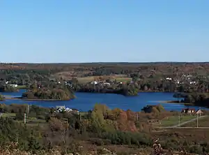
Sydney River
The Sydney River is a short river located in Cape Breton County, Nova Scotia, Canada.[1] Historically, it was also referred to as the Spanish River[3] from the 18th century French name for its estuary, Baie d’Espagnols.[4] It separates the communities of Coxheath and Westmount, on the north bank of the river, from Howie Centre, Sydney River, and Sydney on the south and east banks.
| Sydney River Spanish River | |
|---|---|
 Sydney River, with Coxheath in the foreground and Howie Centre on the opposite bank | |
| Etymology | From the city of Sydney on its estuary. |
| Location | |
| Country | Canada |
| Province | Nova Scotia |
| County | Cape Breton |
| District | Cape Breton Regional Municipality |
| City | Sydney |
| Physical characteristics | |
| Source | Blacketts Lake |
| Mouth | South Arm of Sydney Harbour |
• location | between the Westmount shore near Amelia Point and Battery Point on the Sydney shore[1] |
• coordinates | 46°8′49.4″N 60°13′36.3″W |
• elevation | 0 m (0 ft) |
| Length | 12.5 km (7.8 mi) |
| Basin size | 140 km2 (54 sq mi) |
| Basin features | |
| Tributaries | |
| • left | Crawleys Creek, Barachois Creek |
| • right | Meadows Brook,[2] Tobins Brook, Howies Brook, Gillis Brook, Prime Brook, Wentworth Creek, Muggah Creek |
| Bridges | 125 Highway, Route 305 |
| Inland ports | Port of Sydney |
Sydney River rises in Blacketts Lake and runs 12.5 km (7.8 mi) to its mouth, between the Westmount shore near Amelia Point and Battery Point on the Sydney shore,[1] at the South Arm of Sydney Harbour, draining a watershed of 140 km2 [5]:6 south of the crest of the Coxheath Hills. The river is an estuary for the last 7 km (4.3 mi) below the "Sysco Dam" in the community of Sydney River. The dam was constructed in 1902, converting the stretch of river immediately above the dam from a tidal estuary to a freshwater reservoir lake.[5]:6 Its watershed contains more than 2000 homes.[2]
The Sydney River valley is glacial with thick deposits, kames, eskers and outwash gravels creating a series of shallow lakes connected by narrow channels. This low valley was a traditional canoe portage used by the Mi'kmaq for travelling between Sydney Harbour and the East Bay of Bras d'Or Lake.[6] The river is one of only two Canadian watersheds with a known population of the yellow lampmussel.[2] The lampmussel is found above the dam constructed in 1902,[5]:6 which increased the area of freshwater habitat suitable for lampmussel in the watershed.[5]:8
See also
References
- "Sydney River". Geographical names in Canada. Natural Resources Canada. Retrieved 5 February 2020.
- ACAP Cape Breton. "Warning: Species at Risk! Yellow Lampmussel". Retrieved July 15, 2012.
- Andrews, Edmund (January 1899). Coxheath, or A Century of Civilization (Speech). Archived from the original on 2015-09-22. Retrieved July 15, 2012.
- McKenzie, Charlene (August 3, 2008). "Baie-des-Espagnois". ancestry.com. Retrieved July 16, 2012.
- Fisheries and Oceans Canada (2010), "Management Plan for the Yellow Lampmussel (Lampsilis cariosa) in Canada [Final]", Species at Risk Act Management Plan Series (PDF), Ottawa: Fisheries and Oceans Canada
- "Sydney River (sub-Unit 585b) - The Natural History of Nova Scotia - theme regions". Archived from the original on 2009-11-17. Retrieved 2010-03-09.