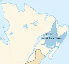
Gulf of Saint Lawrence
The Gulf of Saint Lawrence (French: Golfe du Saint-Laurent) is the outlet of the North American Great Lakes via the Saint Lawrence River into the Atlantic Ocean. The gulf is a semi-enclosed sea, covering an area of about 226,000 square kilometres (87,000 sq mi) and containing about 34,500 cubic kilometres (8,300 cu mi) of water, which results in an average depth of 152 metres (499 ft).[1]
| Gulf of Saint Lawrence | |
|---|---|
| French: Golfe du Saint-Laurent | |
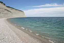 Gulf of Saint Lawrence from Anticosti National Park, Quebec | |
 | |
| Coordinates | 48°36′N 61°24′W |
| Type | Gulf |
| Basin countries | Canada Saint Pierre and Miquelon (France) |
| Surface area | 226,000 km2 (87,000 sq mi)[1] |
| Average depth | 152 m (499 ft)[1] |
| Water volume | 34,500 km3 (8,300 cu mi)[1] |
Geography
.jpg.webp)
The Gulf of Saint Lawrence is bounded on the north by the Labrador Peninsula and Quebec, to the east by Saint-Pierre and Newfoundland, to the south by the Nova Scotia peninsula and Cape Breton Island, and to the west by the Gaspe Peninsula, New Brunswick, and Quebec. As for significant islands the Gulf of Saint Lawrence contains Anticosti Island, Prince Edward Island, Îles-de-la-Madeleine, Cape Breton Island, Saint Pierre Island, and Miquelon-Langlade.
Half of the ten provinces of Canada adjoin the Gulf: New Brunswick, Nova Scotia, Prince Edward Island, Newfoundland and Labrador, and Quebec.
Besides the Saint Lawrence River itself, significant streams emptying into the Gulf of Saint Lawrence include the Miramichi River, Natashquan River, Romaine River, Restigouche River, Margaree River, and Humber River.
Branches of the Gulf include the Chaleur Bay, Fortune Bay, Miramichi Bay, St. George's Bay, Bay St. George, Bay of Islands, and Northumberland Strait.
Outlets
The gulf flows into the Atlantic Ocean through the following outlets:
- The Strait of Belle Isle between Labrador and Newfoundland: between 15 kilometres (9.3 miles) and 60 kilometres (37 miles) wide and 60 metres (200 feet) deep at its deepest.
- The Cabot Strait between Newfoundland and Saint-Pierre and Cape Breton Island: 104 km (65 mi) wide and 480 m (1,570 ft) deep at its deepest.
- The Strait of Canso between Cape Breton Island and the Nova Scotia peninsula: 1.0 km (0.6 mi) wide and 60 m (200 ft) deep at its deepest. Due to the construction of the Canso Causeway across the strait in 1955, it no longer permits exchange of water between the Gulf of Saint Lawrence and the Atlantic Ocean.
Extent
The limits of the Gulf of Saint Lawrence vary between sources.
The International Hydrographic Organization defines the limits of the Gulf of Saint Lawrence as follows:[2]
On the Northeast.
A line running from Cape Bauld (North point of Kirpon Island, 51°40′N 55°25′W) to the East extreme of Belle Isle and on to the Northeast Ledge (52°02′N 55°15′W). Thence a line joining this ledge with the East extreme of Cape St. Charles (52°13'N) in Labrador.
On the Southeast.
A line from Cape Canso (45°20′N 61°0′W) to Red Point (45°35′N 60°45′W) in Cape Breton Island, through this Island to Cape Breton [45°57′N 59°47′W] and on to Pointe Blanche (46°45′N 56°11′W) in the Island of St. Pierre, and thence to the Southwest point of Morgan Island (46°51′N 55°49′W).
On the West.
The meridian of 64°30'W from Pointe-Jaune (49°04′N 64°30′W) to Magpie (50°19′N 64°30′W), but the whole of Anticosti Island is included in the Gulf.
Fisheries and Oceans Canada places the western limit at Pointe-des-Monts, approximately 138 km (85.8 mi) west of the 64°30'W meridian.[3]
Protected areas
St. Paul Island, Nova Scotia, off the northeastern tip of Cape Breton Island, is referred to as the "Graveyard of the Gulf" because of its many shipwrecks. Access to this island is controlled by the Canadian Coast Guard.
Bonaventure Island on the eastern tip of the Gaspe Peninsula, Île Brion and Rochers-aux-Oiseaux (Bird Rock) northeast of the Magdalen Islands[4] are important migratory bird sanctuaries administered by the Canadian Wildlife Service.
The Federal Government of Canada has national parks along the Gulf of Saint Lawrence at Forillon National Park on the eastern tip of the Gaspe Peninsula, Prince Edward Island National Park on the northern shore of the island, Kouchibouguac National Park on the northeastern coast of New Brunswick, Cape Breton Highlands National Park on the northern tip of Cape Breton Island, Gros Morne National Park on the west coast of Newfoundland, and a National Park Reserve in the Mingan Archipelago on the Côte-Nord of Quebec.
The five provinces bordering the Gulf of Saint Lawrence also have several provincial parks apiece, some of which preserve coastal features.
Undersea features
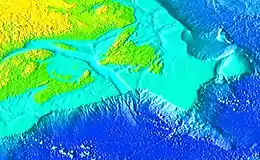
The Laurentian Channel is a feature of the floor of the Gulf that was formed during previous ice ages, when the Continental Shelf was eroded by the Saint Lawrence River during the periods when the sea level plunged. The Laurentian Channel is about 290 m (950 ft) deep and about 1,250 km (780 mi) long from the Continental Shelf to the mouth of the Saint Lawrence River. Deep waters with temperatures between 2 and 6.5 °C (36 and 44 °F) enter the Gulf at the continental slope and are slowly advected up the channel by estuariane circulation.[5] Over the 20th century, the bottom waters of the end of the channel (i.e. in the Saint Lawrence estuary) have become hypoxic.[6]
History
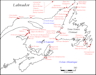
The gulf has provided a historically important marine fishery for various First Nations that have lived on its shores for millennia and used its waters for transportation.
The first documented voyage by a European in its waters was by the French explorer Jacques Cartier in the year 1534. Cartier named the shores of the Saint Lawrence River "The Country of Canadas", after an indigenous word meaning "village" or "settlement", thus naming the world's second largest country.[7]
At just about the same period, Basques came to frequent the area for whale-hunting and trade with the First Nations people of the modern Canadian Atlantic and Quebec provinces. They left vestiges of their presence in many locations of the area—docks, furnaces, graveyards, etc. See History of Basque whaling, section Newfoundland and Labrador.
See also
References
- "Atlantic region, Government of Canada, page 86" (PDF). publications.gc.ca. Retrieved 14 March 2018.
- "Limits of Oceans and Seas, 3rd edition" (PDF). International Hydrographic Organization. 1953. Archived from the original (PDF) on 8 October 2011. Retrieved 28 December 2020.
- "Fisheries and Oceans Canada - Quebec Region - Estuary and Gulf of St. Lawrence". www.qc.dfo-mpo.gc.ca. Retrieved 14 March 2018.
- "Parks Reserves and Natural Sites". Tourisme Îles de la Madeleine.
- Galbraith, P.S., Pettipas, R.G., Chassé, J., Gilbert, D., Larouche, P., Pettigrew, B., Gosselin, A., Devine, L. and Lafleur, C. 2009. Physical Oceanographic Conditions in the Gulf of St. Lawrence in 2008. DFO Can. Sci. Advis. Sec. Res. Doc. 2009/014. iv + 69 p.
- Gilbert, D., B. Sundby, C. Gobeil, A. Mucci and G.-H. Tremblay. 2005. A seventy-two-year record of diminishing deep-water oxygen in the St. Lawrence estuary: The northwest Atlantic connection. Limnol. Oceanogr., 50(5): 1654–1666.
- Document "Discovers Gulf of Saint Lawrence" http://www.csmonitor.com/The-Culture/Family/2013/0812/1912-eighth-grade-exam-Could-you-make-it-to-high-school-in-1912/Discoverers-Gulf-of-Saint-Lawrence/ Document "Discovers Gulf of Saint Lawrence" Check
|url=value (help). Missing or empty|title=(help)
External links
| Wikimedia Commons has media related to Gulf of Saint Lawrence. |
- St. Lawrence Global Observatory
- The Gulf of St. Lawrence - A Unique Ecosystem, Department of Fisheries and Oceans
- Timing and position of late Wisconsinan ice-margins on the upper slope seaward of Laurentian Channel
| Authority control |
|---|