Tótkomlós
Tótkomlós (Slovak: Slovenský Komlóš) is a town in Békés County, Hungary.
Tótkomlós
Slovenský Komlóš (in Slovak) | |
|---|---|
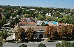 View from the Protestant church tower | |
 Flag  Coat of arms | |
 Tótkomlós | |
| Coordinates: 46.417°N 20.733°E | |
| Country | |
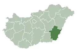
| County | Békés |
| District | Orosháza |
| Area | |
| • Total | 125.05 km2 (48.28 sq mi) |
| Population (2012) | |
| • Total | 5,780 |
| • Density | 46.22/km2 (119.7/sq mi) |
| Time zone | UTC+1 (CET) |
| • Summer (DST) | UTC+2 (CEST) |
| Postal code | 5940 |
| Area code | (+36) 68 |
| Website | www |
Name
Komlós means "(place) with hops" in Hungarian, while prefix Tót is the word for Slovaks in old Hungarian. Hops also can be found in the coat of arms of the town.
Geography
Tótkomlós is located in the Great Hungarian Plain 225 kilometres (140 miles) southeast from Budapest. Mezőtúr-Orosháza-Mezőhegyes railway line crosses the town.[1]
History
The Medieval village was ruined due to the Ottoman wars, native Hungarian population fled from the area. It was rebuilt after 1715 with Slovak settlers. Hungarians became the majority after the Czechoslovak-Hungarian population exchange.[2]
People
- János Jankó (1833–1896), Hungarian painter
- Pál Závada (1954), Hungarian writer
International relations
References
- Magyarország autóatlasz, Dimap-Szarvas, Budapest, 2004, ISBN 963-03-7576-1
- Károly Kocsis (DSc, University of Miskolc) – Zsolt Bottlik (PhD, Budapest University) – Patrik Tátrai: Etnikai térfolyamatok a Kárpát-medence határon túli régióiban, Magyar Tudományos Akadémia (Hungarian Academy of Sciences) – Földrajtudományi Kutatóintézet (Academy of Geographical Studies); Budapest; 2006.; ISBN 963-9545-10-4, CD Atlas
External links
| Wikimedia Commons has media related to Tótkomlós. |
- Official website in Hungarian and Slovak
| Towns (2) | ||
|---|---|---|
| Large villages (2) | ||
| Villages (4) | ||
| City with county rights |
|   |
|---|---|---|
| Towns | ||
| Large villages | ||
| Villages |
| |
| Other topics |
| |
| Authority control |
|---|
This article is issued from Wikipedia. The text is licensed under Creative Commons - Attribution - Sharealike. Additional terms may apply for the media files.