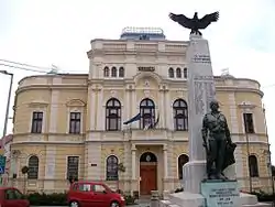
Mezőberény
Mezőberény (Hungarian pronunciation: [ˈmɛzøːbɛreːɲ]; German: Maisbrünn; Slovak: Poľný Berinčok) is a town in Békés county, Hungary.
Mezőberény | |
|---|---|
 | |
 Flag  Coat of arms | |
 Mezőberény | |
| Coordinates: 46.4932°N 21.144°E | |
| Country | |
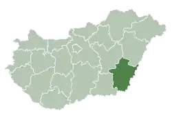
| County | Békés |
| District | Békés (district) |
| Area | |
| • Total | 118.53 km2 (45.76 sq mi) |
| Population (2009) | |
| • Total | 11,241 |
| • Density | 97.79/km2 (253.3/sq mi) |
| Time zone | UTC+1 (CET) |
| • Summer (DST) | UTC+2 (CEST) |
| Postal code | 5650 |
| Area code | (+36) 66 |
| Website | www |
Location
Mezőberény is located in the Great Hungarian Plain, 200 km southeast from Budapest. Highway 46, 47 and Budapest-Szolnok-Békéscsaba-Lökösháza high speed (120–160 km/h (75–99 mph)) railway line also cross the town.[1]
History
The Medieval village of Berény was ruined due to the Ottoman wars, native Hungarian population fled from the area. It was rebuilt in the 18th century with German, Hungarian and Slovak settlers and was a multiethnic town until the late 19th century, when Germans and Slovaks adopted the Hungarian language.[2]
Notable people
- Soma Orlai Petrich (1822–1880), Hungarian painter
Twin towns — sister cities
References
- Magyarország autóatlasz, Dimap-Szarvas, Budapest, 2004, ISBN 963-03-7576-1
- Károly Kocsis (DSc, University of Miskolc) – Zsolt Bottlik (PhD, Budapest University) – Patrik Tátrai: Etnikai térfolyamatok a Kárpát-medence határon túli régióiban, Magyar Tudományos Akadémia (Hungarian Academy of Sciences) – Földrajtudományi Kutatóintézet (Academy of Geographical Studies); Budapest; 2006.; ISBN 963-9545-10-4, CD Atlas
External links
- Official website of Mezőberény (Hungarian)
- Guide Mezőberény (Hungarian)
External links
| Wikimedia Commons has media related to Mezőberény. |
- Official website in Hungarian
| Towns (2) |
| |
|---|---|---|
| Villages (5) | ||
| City with county rights |
|   |
|---|---|---|
| Towns | ||
| Large villages | ||
| Villages |
| |
| Other topics |
| |
| Authority control |
|---|
This article is issued from Wikipedia. The text is licensed under Creative Commons - Attribution - Sharealike. Additional terms may apply for the media files.