Tabuenca
Tabuenca is a municipality located in the province of Zaragoza, Aragon, Spain. According to the 2010 census the municipality has a population of 412 inhabitants.[2] Its postal code is 50547.
Tabuenca | |
|---|---|
 Flag  Seal | |
| Country | Spain |
| Autonomous community | Aragon |
| Province | Zaragoza |
| Comarca | Campo de Borja |
| Area | |
| • Total | 85 km2 (33 sq mi) |
| Elevation | 779 m (2,556 ft) |
| Population (2018)[1] | |
| • Total | 323 |
| • Density | 3.8/km2 (9.8/sq mi) |
| Time zone | UTC+1 (CET) |
| • Summer (DST) | UTC+2 (CEST) |
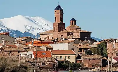
The town is located in a mountainous area west of the Moncayo Massif, close to the Sierra de Tabuenca, also known as Sierra del Bollón', after its highest peak, El Bollón (1036 m).[3]
References
- Municipal Register of Spain 2018. National Statistics Institute.
- Instituto Nacional de Estadística (Spain)
- Ascensión a el Bollón
External links
| Wikimedia Commons has media related to Tabuenca. |
| Authority control |
|
|---|
This article is issued from Wikipedia. The text is licensed under Creative Commons - Attribution - Sharealike. Additional terms may apply for the media files.
