Tadten
Tadten (Hungarian: Mosontétény) is a village in the district of Neusiedl am See in Burgenland in Austria.
Tadten | |
|---|---|
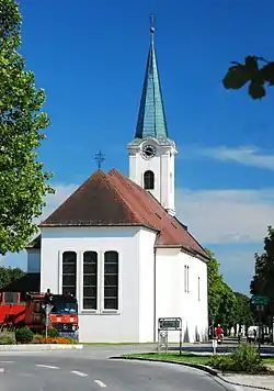 Saint Michael Church | |
 Coat of arms | |
 Tadten Location within Austria | |
| Coordinates: 47°46′N 16°59′E | |
| Country | Austria |
| State | Burgenland |
| District | Neusiedl am See |
| Government | |
| • Mayor | Willibald Goldenits (ÖVP) |
| Area | |
| • Total | 36.06 km2 (13.92 sq mi) |
| Population (2018-01-01)[2] | |
| • Total | 1,186 |
| • Density | 33/km2 (85/sq mi) |
| Time zone | UTC+1 (CET) |
| • Summer (DST) | UTC+2 (CEST) |
| Postal code | 7162 |
Tadten is a wine growing village with 1,234 inhabitants and lies at the transition from the Seewinkel region to the Hungarian puszta. In 1357 Tadten, then called "Tetun", was mentioned in a conflict of possession by the Raab chapter. The first settlement dates back to the 2nd century BC. The village has been destroyed several times by the Turks and Kurruzzen. In the 17th century Tadten came into the possession of the Esterhazy family. A Roman Catholic church was built in 1804 under Count Esterhazy. The church was enlargened in 1954 to its present size.
120 m Elevation 1355 Inhabitants
Tadten national park village
The area south of the village up to the state border at the artificial channel Einserkanal is covered by marshy meadows of the Hanság landscape.
References
- "Dauersiedlungsraum der Gemeinden Politischen Bezirke und Bundesländer - Gebietsstand 1.1.2018". Statistics Austria. Retrieved 10 March 2019.
- "Einwohnerzahl 1.1.2018 nach Gemeinden mit Status, Gebietsstand 1.1.2018". Statistics Austria. Retrieved 9 March 2019.
| Authority control |
|---|
