Tamarindo, Costa Rica
Tamarindo is a district of the Santa Cruz canton, in the Guanacaste province of Costa Rica, located on the Nicoya Peninsula.[1][2] The town of Tamarindo is the largest developed beach town in Guanacaste. Main attractions in the area are surfing and eco-tourism.
Tamarindo | |
|---|---|
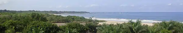
 The coastline in Tamarindo | |
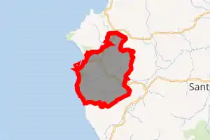
Tamarindo district | |
 Tamarindo Tamarindo district location in Costa Rica | |
| Coordinates: 10.2923417°N 85.798175°W | |
| Country | |
| Province | Guanacaste |
| Canton | Santa Cruz |
| Creation | 27 November 1995 |
| Area | |
| • Total | 125.86 km2 (48.59 sq mi) |
| Elevation | 27 m (89 ft) |
| Population (2011) | |
| • Total | 6,375 |
| • Density | 51/km2 (130/sq mi) |
| Time zone | UTC−06:00 |
| Postal code | 50309 |

History
Tamarindo was created on 27 November 1995 by Decreto Ejecutivo 24820-G.[2]
Settlements
Towns belonging to the district besides Tamarindo include Villarreal, Santa Rosa, Garita Nueva, Hernández and San José de Pinilla.[4]
Villareal
The nearby town of Villareal has a both a public Elementary school and a public High-school, two full size soccer fields, multiple restaurants, two large stores, multiple hardware stores, a police station, a church, several car repair shops and a fuel station.
Langosta
Just east of the centre of Tamarindo, there is a 3-way intersection. To the left is the road that leads to the Banco Nacional de Costa Rica, and also a secondary exit from Tamarindo. To the right is the road that leads to Langosta.
Tourism
Beaches
Playa Tamarindo is a long, rocky beach with excellent waves near the mouth of the estuary. Currents can be strong, especially on a falling tide. Tamarindo has two main breaks for advanced surfers: Pico Pequeño a rocky point to the right of the Hotel Tamarindo Diriá and the excellent river mouth break across from Cabinas Tsunami called El Estero. The biggest waves can reach a height of up to 12 feet, although this is a rare occurrence and is only seen during June, July and August.
The beaches in the area are generally clean and recent efforts by the government and local business organizations are proving themselves. While the beach has not regained its Blue Flag Status,[5] in September 2008 it did get a clean bill of health from the Costa Rican Government. The town is trying to regain its Blue Flag Status.[6]
Demographics
| Historical population | |||
|---|---|---|---|
| Census | Pop. | %± | |
| 2000 | 3,525 | — | |
| 2011 | 6,375 | 80.9% | |
|
Instituto Nacional de Estadística y Censos[7] |
|||
For the 2011 census, Tamarindo had a population of 6,375 inhabitants. [9]
Transportation
Road transportation
The district is covered by the following road routes:
Airport
Tamarindo is the most accessible location along the northern Pacific coast of Costa Rica with an airstrip.
Liberia International Airport is the closest international airport to Tamarindo, about an hour away.
Public transportation
There is a scheduled daily bus service to and from San José, and a paved highway from San José with an average driving time of 3.5 to 6 hours depending on traffic.
Gallery
See also
References
- "Declara oficial para efectos administrativos, la aprobación de la División Territorial Administrativa de la República N°41548-MGP". Sistema Costarricense de Información Jurídica (in Spanish). 19 March 2019. Retrieved 26 September 2020.
- División Territorial Administrativa de la República de Costa Rica (PDF) (in Spanish). Editorial Digital de la Imprenta Nacional. 8 March 2017. ISBN 978-9977-58-477-5.
- "Área en kilómetros cuadrados, según provincia, cantón y distrito administrativo". Instituto Nacional de Estadística y Censos (in Spanish). Retrieved 26 September 2020.
- "Tamarindo". Retrieved 2015-03-28.
- http://www.blueflag.org/
- Tamarindo News
- "Instituto Nacional de Estadística y Censos" (in Spanish).
- "Sistema de Consulta de a Bases de Datos Estadísticas". Centro Centroamericano de Población (in Spanish).
- "Censo. 2011. Población total por zona y sexo, según provincia, cantón y distrito". Instituto Nacional de Estadística y Censos (in Spanish). Retrieved 26 September 2020.
| Liberia |
|
|---|---|
| Nicoya | |
| Santa Cruz | |
| Bagaces | |
| Carrillo | |
| Cañas | |
| Abangares | |
| Tilarán | |
| Nandayure | |
| La Cruz | |
| Hojancha | |
External links
| Wikimedia Commons has media related to Tamarindo. |