Louhajang River
Louhajang River (Bengali: লৌহজং নদী [lowɦɔdʒɔŋ nɔdi]) is located in central Bangladesh. It branches out from the Jamuna near Gabsain at Bhuapur, Tangail District.[1] Thereafter it splits into two parts before the parts meet up again. It flows past Tangail city, Karotia and Jamurki before joining the Bangshi.[2] The Louhajang is linked with the Dhaleshwari.[3]
| Louhajang River | |
|---|---|
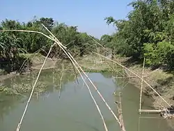 Louhajang River in Tangail District | |
| Location | |
| Country | Bangladesh |
| Division | Dhaka |
| District | Tangail |
| Physical characteristics | |
| Source | Jamuna River |
| • location | Gabsa Ain, Tangail |
| Mouth | Dhaleshwari River |
| Discharge | |
| • location | Bangshi River |
The average depth is 1 metre (3 ft) and maximum depth is 3 metres (9 ft).
Until around the 1980s, launches and big boats carrying merchandise anchored at Tangail. A road at College Para in the town was named "Amghat" as mangoes from Rajshahi were unloaded there. Besides, the river linked shoals in the western part with rest of the district. The river started dying after the Water Development Board constructed a sluice gate near the confluence of Louhajang and Dhaleshwari rivers in 1992 under its Flood Action Plan-20. Boats stopped plying the route since then as the river lost navigability. In the subsequent years, encroachment of its banks and shore areas increased.[4]
References
- "খাল বিল নদী". টাঙ্গাইল জেলা. Archived from the original on 12 December 2013. Retrieved 11 December 2014.
- Mazumdar, Kedarnath, Moymonshingher Itihash O Moymonsingher Biboron, 2005, (in Bengali), p. 152, Anandadhara, 34/8 Banglabazar, Dhaka.
- Map of Rivers of Bangladesh produced by Graphosman, 55/1 Purana Paltan, Dhaka 1000.
- "No step yet to free Louhajang, Bairan rivers from grabbers". The Daily Star. 23 April 2007. Retrieved 2007-12-01.
External links
| Wikimedia Commons has media related to Louhajang River. |
- Islam, Nazrul (2012). "Tangail Sadar Upazila". In Islam, Sirajul; Jamal, Ahmed A. (eds.). Banglapedia: National Encyclopedia of Bangladesh (Second ed.). Asiatic Society of Bangladesh. Includes a map of the river.
