Tanqwa
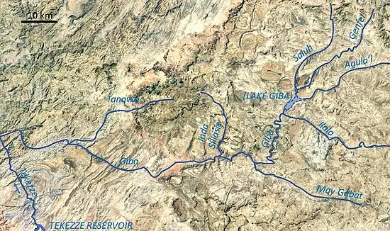
Tanqwa is a river of northern Ethiopia. Rising in the mountains of Dogu’a Tembien (2510 metres above sea level), it flows westward to Giba River which empties finally in the Tekezé River.[2]
| Tanqwa | |
|---|---|
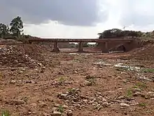
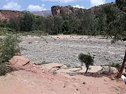 The Tanqwa River near Abiy Addi | |
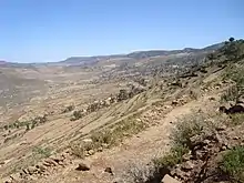
 Tanqwa River in Tigray Region | |
| Location | |
| Country | Ethiopia |
| Region | Tigray Region |
| Districts (woreda) | Dogu’a Tembien, Kola Tembien, Abergele |
| Physical characteristics | |
| Source | Addi Selam |
| • location | Hagere Selam municipality |
| • elevation | 2,510 m (8,230 ft) |
| Mouth | Giba River |
• location | Barashuwa in Abergele (woreda) |
• coordinates | 13.528°N 39.878°E |
• elevation | 1,266 m (4,154 ft) |
| Length | 50 km (31 mi) |
| Basin size | 216 km2 (83 sq mi) |
| Width | |
| • average | 40 m (130 ft) |
| Discharge | |
| • location | Abiy Addi bridge[1] |
| • maximum | 270 m3/s (9,500 cu ft/s) |
| Discharge | |
| • location | Confluence with Giba[1] |
| • maximum | 543 m3/s (19,200 cu ft/s) |
| Basin features | |
| River system | Permanent river |
| Landmarks | Abiy Addi |
| Tributaries | |
| • left | Adawro River, Arwadito, May Qoqah, Tsech'i River |
| Waterbodies | Chini (reservoir) |
| Waterfalls | Rapids |
| Bridges | Abiy Addi |
| Topography | Mountains and deep gorges |
Hydrography
It is a confined river, locally meandering in its narrow alluvial plain, with a slope gradient of 25 metres per kilometre. With its tributaries, the river has cut a deep gorge.[3]
Tributaries
Hydrology
Hydrological characteristics
The runoff footprint or annual total runoff volume is 41 million m³ at the bridge in Abiy Addi and 79 million m³ at the confluence with Giba River at Barashuwa. Peak discharges up to 543 m³ per second occur in the second part of the rainy season (month of August) when there are strong rains and the soils are saturated with water in many places. The percentage of total rainfall that directly leaves the catchment as storm runoff (also called runoff coefficient) is 23%.[1] This is high, in comparison to other rivers of the Giba River basin, and has been explained by the fact that the larger part of the Tanqwa basin is composed of impervious rocks, particularly Ashangi Basalts, Alaji Basalts and Precambrian basement rocks.[3] The total amount of sediment that is transported by this river amounts to 596,000 tonnes per year. Median sediment concentration in the river water is 3.95 grammes per litre, but may go up to 68 g/L. The highest sediment concentrations occur at the beginning of the rainy season, when loose soil and dust is washed away by overland flow and ends up in the river.[4] As such water contains many nutrients (locally it is called “aygi”), farmers estimate that it strengthens their cattle, which they will bring to the river.[3] All in all, average sediment yield is 3627 tonnes per km² and per year. All measurements were done at purposively installed stations, in the years 2006-2007.[4]
Flash floods
Runoff mostly occurs in the form of high runoff discharge events that occur in a very short period (called flash floods). These are related to the steep topography, often little vegetation cover and intense convective rainfall. The peaks of such flash floods have often a 50 to 100 times larger discharge than the preceding baseflow. These flash floods mostly occur during the evening or night, because the convective rain showers occur in the afternoon.[3]
Changes over time
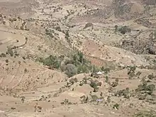
Evidence given by Italian aerial photographs of the catchment, taken in the 1930s show that 63% of the catchment was covered with woody vegetation (against 32% in 2014). This vegetation could slow down runoff and the runoff coefficient was smaller (13% in 1935 against 23% in 2014). As a consequence, discharges in the river were less and the river was narrower than today.[5] Up to the 1980s, there was strong pressure on the environment, and much vegetation disappeared.[6] This river had its greatest discharges and width in that period. The magnitude of floods in this river has however been decreased in recent years due to interventions in the catchment. On other steep slopes, exclosures have been established; the dense vegetation largely contributes to enhanced infiltration, less flooding and better baseflow.[7] Physical conservation structures such as stone bunds[8][9] and check dams also intercept runoff.[10][11]

Transhumance towards the river gorge
The valley bottoms in the gorges of this river have been identified as a transhumance destination zone. Transhumance takes place in the summer rainy season, when the lands near the villages are occupied by crops. Young shepherds will take the village cattle down to the gorge and overnight in small caves. The gorges are particularly attractive as a transhumance destination zone, because there is water and good growth of semi-natural vegetation.[12]
Boulders and pebbles in the river bed
Boulders and pebbles encountered in the river bed can originate from any location higher up in the catchment. In the uppermost stretches of the river, only rock fragments of the upper lithological units will be present in the river bed, whereas more downstream one may find a more comprehensive mix of all lithologies crossed by the river. From upstream to downstream, the following lithological units occur in the catchment.[13]
Natural boundary
During its course, this river passes through nine municipalities and three woredas and constitutes six different borders.[14] From upstream to downstream:
- Border between Hagere Selam and Melfa, both in Dogu’a Tembien
- Border between Lim'at and Melfa, both in Dogu’a Tembien
- Border between Aregen and Melfa, both in Dogu’a Tembien
- Border between Aregen and Degol Woyane, both in Dogu’a Tembien
- Border between Aregen (Dogu’a Tembien) and Geramba (Kola Tembien)
- Crosses the town of Abiy Addi
- Border between Kola Tembien and Abergele (woreda)
Trekking along the river
Trekking routes have been established across and along this river.[15] The tracks are not marked on the ground but can be followed using downloaded .GPX files.[16]
- Trek 6, along the middle Tanqwa course
- Trek 20, along the upper Tanqwa course
In the rainy season, flash floods may occur and it is advised not to follow the river bed. Frequently, it is then also impossible to wade across the river.[17]
See also
- List of Ethiopian rivers
References
- Amanuel Zenebe, and colleagues (2013). "Spatial and temporal variability of river flows in the degraded semi-arid tropical mountains of northern Ethiopia". Zeitschrift für Geomorphologie. 57 (2): 143–169. doi:10.1127/0372-8854/2012/0080.
- Jacob, M. and colleagues (2019). Geo-trekking map of Dogu'a Tembien (1:50,000). In: Geo-trekking in Ethiopia's Tropical Mountains - The Dogu'a Tembien District. SpringerNature. ISBN 978-3-030-04954-6.
- Amanuel Zenebe, and colleagues (2019). The Giba, Tanqwa and Tsaliet rivers in the headwaters of the Tekezze basin. In: Geo-trekking in Ethiopia's Tropical Mountains - The Dogu'a Tembien District. SpringerNature. doi:10.1007/978-3-030-04955-3_14. ISBN 978-3-030-04954-6.
- Vanmaercke, M. and colleagues (2010). "Sediment dynamics and the role of flash floods in sediment export from medium-sized catchments: a case study from the semi-arid tropical highlands in northern Ethiopia". Journal of Soils and Sediments. 10 (4): 611–627. doi:10.1007/s11368-010-0203-9. S2CID 53365853.
- Etefa Guyassa, 2017. PhD thesis. Hydrological response to land cover and management (1935-2014) in a semi-arid mountainous catchment of northern Ethiopia
- Frankl, A., Nyssen, J., De Dapper, M., Mitiku Haile, Billi, P., Munro, R.N., Deckers, J. Poesen, J. 2011. Linking long-term gully and river channel dynamics to environmental change using repeat photography (North Ethiopia). Geomorphology, 129 (3-4): 238-251.
- Descheemaeker, K. and colleagues (2006). "Runoff on slopes with restoring vegetation: A case study from the Tigray highlands, Ethiopia". Journal of Hydrology. 331 (1–2): 219–241. doi:10.1016/j.still.2006.07.011.
- Nyssen, Jan; Poesen, Jean; Gebremichael, Desta; Vancampenhout, Karen; d'Aes, Margo; Yihdego, Gebremedhin; Govers, Gerard; Leirs, Herwig; Moeyersons, Jan; Naudts, Jozef; Haregeweyn, Nigussie; Haile, Mitiku; Deckers, Jozef (2007). "Interdisciplinary on-site evaluation of stone bunds to control soil erosion on cropland in Northern Ethiopia". Soil and Tillage Research. 94 (1): 151–163. doi:10.1016/j.still.2006.07.011. hdl:1854/LU-378900.
- Gebeyehu Taye and colleagues (2015). "Evolution of the effectiveness of stone bunds and trenches in reducing runoff and soil loss in the semi-arid Ethiopian highlands". Zeitschrift für Geomorphologie. 59 (4): 477–493. doi:10.1127/zfg/2015/0166.
- Nyssen, J.; Veyret-Picot, M.; Poesen, J.; Moeyersons, J.; Haile, Mitiku; Deckers, J.; Govers, G. (2004). "The effectiveness of loose rock check dams for gully control in Tigray, Northern Ethiopia". Soil Use and Management. 20: 55–64. doi:10.1111/j.1475-2743.2004.tb00337.x.
- Etefa Guyassa and colleagues (2017). "Effects of check dams on runoff characteristics along gully reaches, the case of Northern Ethiopia". Journal of Hydrology. 545 (1): 299–309. doi:10.1016/j.jhydrol.2016.12.019. hdl:1854/LU-8518957.
- Nyssen, Jan; Descheemaeker, Katrien; Zenebe, Amanuel; Poesen, Jean; Deckers, Jozef; Haile, Mitiku (2009). "Transhumance in the Tigray highlands (Ethiopia)". Mountain Research and Development. 29 (3): 255–264. doi:10.1659/mrd.00033.
- Sembroni, A.; Molin, P.; Dramis, F. (2019). Regional geology of the Dogu'a Tembien massif. In: Geo-trekking in Ethiopia's Tropical Mountains — The Dogu'a Tembien District. SpringerNature. ISBN 978-3-030-04954-6.
- Jacob, M. and colleagues (2019). Geo-trekking map of Dogu'a Tembien (1:50,000). In: Geo-trekking in Ethiopia's Tropical Mountains - The Dogu'a Tembien District. SpringerNature. ISBN 978-3-030-04954-6.
- Description of trekking routes in Dogu'a Tembien. In: Geo-trekking in Ethiopia's Tropical Mountains - The Dogu'a Tembien District. SpringerNature. 2019. ISBN 978-3-030-04954-6.
- https://www.openstreetmap.org/traces/tag/nyssen-jacob-frankl
- Nyssen, Jan (2019). "Logistics for the Trekker in a Rural Mountain District of Northern Ethiopia". Geo-trekking in Ethiopia's Tropical Mountains. GeoGuide. Springer-Nature. pp. 537–556. doi:10.1007/978-3-030-04955-3_37. ISBN 978-3-030-04954-6.