Tata, Hungary
Tata (German: Totis), (Latin: Dotis) is a town in Komárom-Esztergom county, northwestern Hungary, 9 km (6 mi) northwest of the county town Tatabánya.
Tata
Dotis (in Latin) Totis (in German) | |
|---|---|
  _2.jpg.webp)  .jpg.webp) 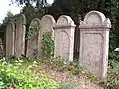 | |
Flag  Coat of arms | |
 Tata Location of Tata in Hungary | |
| Coordinates: 47.6526°N 18.3238°E | |
| Country | |
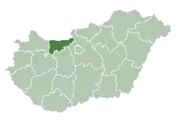
| County | Komárom-Esztergom |
| District | Tata |
| Government | |
| • Mayor | József Michl (Fidesz-KDNP) |
| Area | |
| • Total | 78.17 km2 (30.18 sq mi) |
| Population (2017) | |
| • Total | 23,217[1] |
| • Demonym | tatai |
| Population by ethnicity | |
| • Hungarians | 85.3% |
| • Germans | 2.7% |
| • Gypsies | 0.8% |
| • Slovaks | 0.3% |
| • Romanians | 0.2% |
| • Croats | 0.1% |
| • Others | 1.3% |
| Population by religion | |
| • Roman Catholic | 31.5% |
| • Greek Catholic | 0.4% |
| • Calvinists | 13.7% |
| • Lutherans | 1.4% |
| • Jews | 0.1% |
| • Other | 1.1% |
| • Non-religious | 21.0% |
| • Unknown | 30.7% |
| Time zone | UTC+1 (CET) |
| • Summer (DST) | UTC+2 (CEST) |
| Postal code | 2890 |
| Area code | (+36) 34 |
| Motorways | M1 |
| Distance from Budapest | 68.2 km (42.4 mi) East |
| Website | www |
Location
Tata is located in the valley between the Gerecse Mountains and Vértes Mountains, some 70 km (43 mi) from Budapest, the Hungarian capital city. By virtue of its location, it is a railway and road junction. Motorway M1 (E60, E75) from Vienna to Budapest passes through the outer city limits, and the railway line Budapest–Vienna goes through the city.
Demographics
According to the 2001 census, the town has 23,937 inhabitants: 93.3% Hungarians, 1.6% Germans, 0.6% Roma, 0.2% Slovaks and 6.5% other.[4]
History
The area has been inhabited since prehistoric times; archaeological findings date back to 50,000 BCE. Later it was a Roman settlement.
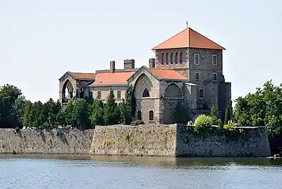
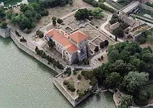
The first known mention of Tata is from 1221. Its castle was built by the Lackfi family and had its prime under Matthias Corvinus, who had it rebuilt in a Renaissance style.
In 1526 when the disastrous battle with the Turks happened and Louis II died in the battlefield, Count György Cseszneky was the castellan of the Castle Tata. The plundering Ottoman army ransacked the area, but Cseszneky successfully defended the castle.
During the Ottoman occupation, the castle of Tata was an important fortress. It was captured in 1543 by the Turks. During this period the castle had many different owners until it was burned down by the Habsburgs in retaliation for the Rákóczi's War of Independence.
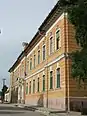
In 1727, Count József Esterházy bought Tata and the surrounding villages. The town prospered, in 1765 it already had a secondary school.
According to the article in the Pallas Lexicon about Tata in 1851, the town was a "pretty and developing village in the Tata district of Komárom comitatus; 895 buildings, 6925 mostly Hungarian residents (3633 Roman Catholics, 2518 Lutherans and 673 Israelites), centre of the district, with secondary school, railway station, post office. Tata and the adjoining village Tóváros (4257 residents) are built around a large lake, Tata on the hillside, Tóváros on the plain. Between them there is the Esterházy mansion and an old castle with archive and gallery including a painting of Leonardo da Vinci. The theatre was built in 1889. The mansion is surrounded by the beautiful English garden (140 hectares)."[5]
In 1938, the village of Tóváros was annexed to Tata, which was renamed Tatatóváros for a short while; one year later it was named Tata again.
During World War II, Tata was captured by Soviet troops of the 2nd Ukrainian Front on 19 March 1945 in the course of the Vienna Offensive.
Tata was granted town status in 1954.
Main sights
- Castle next to the Öreg-tó (Old Lake)
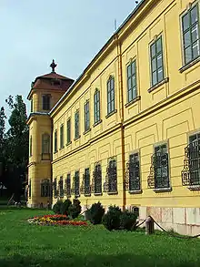
- The Esterházy Palace
- Heroes' Square with World War I monument and synagogue
- Kossuth Square with town hall
- The parish church of Tata
- The Capuchin church
- Calvary Hill
- Lookout tower
- Water mills
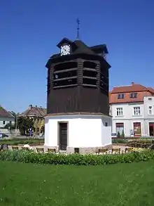
- Belfry
- The English Park
- False ruins
- Fényes Bath
- Turkish Mescid
Notable people
- Móric Fischer de Farkasházy (1799–1880), porcelain-manufacturer, one of the founders of the Herend Porcelain manufactory in 1839
- Csilla Földi (born 1968), retired weightlifter
- Lívia Járóka (born 1974), politician (Fidesz), first Romani woman to be elected to the European Parliament
- Dávid Korányi, political adviser
- Dóra Lőwy (born 1977), former team handball player and Olympic medalist
- Joci Pápai (born 1981), singer, representative for Hungary at the Eurovision Song Contest 2017
- Zsófia Tóth (born 1989), triathlete
- Slavko Wolf (1862–1936), Croatian lawyer, chess player and writer.
- Zoltan Bathory (Born 1978), founder and rhythm guitarist of Five Finger Death Punch.
Twin towns — sister cities
Tata, Hungary is twinned with:
 Alkmaar, Netherlands, since 1985
 Gerlingen, Germany, since 1987
 Dammarie-lès-Lys, France, since 1993
 Arenzano, Italy, since 1994
 Svodín, Slovakia, since 1997
- Montebelluna, Italy, since 2000
 Sovata, Romania, since 2002
 Pińczów, Poland, since 2004
References
- Tata, KSH
- KSH - Tata, 2011
- KSH - Tata, 2011
- "4.1.11 Population by ethnicity".
- Pallas Lexicon
Notes
- Neal Bedford and Lisa Dunford. Lonely Planet, 2009, p. 159-162.
External links
| Wikimedia Commons has media related to Tata. |
- Official website in Hungarian
- Tata photo gallery
- Tata at funiq.hu
| Town (1) |
| |
|---|---|---|
| Villages (9) | ||
| City with county rights |
|   |
|---|---|---|
| Towns | ||
| Large villages | ||
| Villages |
| |
| Other topics |
| |
| Authority control |
|---|