Tatsuno, Hyōgo
Tatsuno (たつの市, Tatsuno-shi) is a city located in Hyōgo Prefecture, Japan. The city was founded on April 1, 1951.
Tatsuno
たつの市 | |||||||||||
|---|---|---|---|---|---|---|---|---|---|---|---|
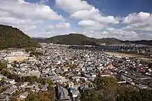
 Top left:Tatsuno Castle, Top right:Tatsuno Park, Middle left:Port of Murotsu, Middle right:iinonimasu Amaterasu Shrine, Bottom left:Ibo River, Bottom right:Panorama view of downtown Tatsuno | |||||||||||
 Flag  Seal | |||||||||||
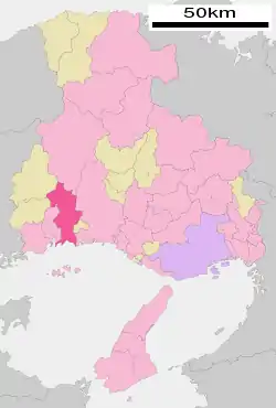 Location of Tatsuno in Hyōgo Prefecture | |||||||||||
 Tatsuno Location in Japan | |||||||||||
| Coordinates: 34°51′03″N 134°32′43″E | |||||||||||
| Country | Japan | ||||||||||
| Region | Kansai | ||||||||||
| Prefecture | Hyōgo Prefecture | ||||||||||
| Government | |||||||||||
| • Mayor | Masanori Nishida (since November 2005) | ||||||||||
| Area | |||||||||||
| • Total | 210.93 km2 (81.44 sq mi) | ||||||||||
| Population (April 1, 2017) | |||||||||||
| • Total | 77,968 | ||||||||||
| • Density | 370/km2 (960/sq mi) | ||||||||||
| Time zone | UTC+09:00 (JST) | ||||||||||
| City hall address | Tatsuno Tominaga 1005-1, Tatsuno City, Hyogo Prefecture (兵庫県たつの市龍野町富永1005-1) 679-4192 | ||||||||||
| Website | www | ||||||||||
| |||||||||||
As of April 1, 2017, the city has an estimated population of 77,968, with 30,300 households,[1] and a population density of 370 persons per km². The total area is 210.93 km².
 Murotsu Port |
 Bourg in Tatsuno Castle (Old city) |
Overview
On October 1, 2005, the towns of Ibogawa, Mitsu and Shingū (all from Ibo District) were merged into Tatsuno. To reflect the new character of the city, the kanji characters in the city's name were changed from 龍野市 to たつの市.
Samurai residences and white-plastered earthen storehouses, remnants of Tatsuno Domain's castle town (assessed at 53,000 koku), still stand in the heart of the city in Tatsuno-chō. Therefore, the city is known as "Little Kyoto of Harima". [2]
The city's name is spelled "たつの," using hiragana, but the name of Tatsuno Station uses the kanji characters "竜野," while the historic name for the place uses the characters "龍野." According to the Harima no Kuni Fudoki, the origin of the name "Tatsuno" was that upon the death of Nomi no Sukune in Ibo District (now in the city of Tatsuno), many came from Izumo and used rock from the Ibo River to make a grave, standing stones in a row on the plain. Thus, it was called "立野," with characters meaning "stand" and "plain," from which it is thought to have changed to "龍野".[3][4] Nomi no Sukune Shrine is located at the place said to be his grave.
Geography
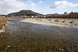
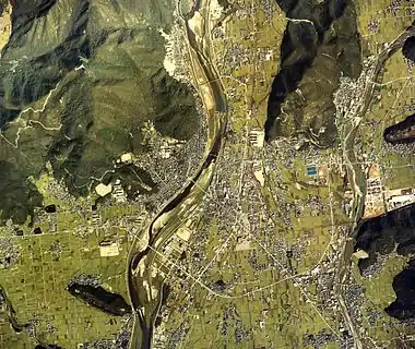
The city lies in southwestern Hyōgo Prefecture extending largely south to north. The city's northern region is mountainous, the southern region faces the Seto Inland Sea, and the Ibo River runs through from north to south.
- Mountains: Mt. Ayabe (in Mitsu-chō)
- Rivers: Ibo River, Kurisu River
- Passes and Hills: Aisaka Pass (Japan National Route 179), Futagi Pass (Prefectural Route 5), Azawara Pass, Iwami Pass
 Mt. Ayabe
 Ibo River
Taken at Hashisaki, Shingū-chō Iwami Hill
Neighboring Municipalities
25.0% of those commuting to work go to Himeji (2010 National Census).
- North: Shisō; Sayō, Sayō District
- West: Aioi; Kamigōri, Akō District
- East: Himeji; Taishi, Ibo District
- South: Himeji (Ieshima Islands)
Population
According to the 2010 national census, the population was 80,541, a decrease of 1.25% compared to the previous census. The rate of change was ranked 17th among the prefecture’s 41 cities and towns, and 23rd among all 49 administrative districts. The population was 81,500 people at the time of the city merger, but there has been a slight decrease to about 79,500 people.
History
Before Tatsuno's Formation
The Tatsuno area was an important location for traffic on the Izumo Highway running along the Ibo River, and was the location of Kinoyama Castle, the headquarters for the Akamatsu clan in medieval times. After Oda Nobunaga gained supremacy during the Warring States period, the area became the territory of the Ikeda clan in the Himeji Domain in the early Edo period. Following Ikeda Toshitaka's death, the land was taken over by Honda Masatomo, the Tatsuno Domain was established, and the castle town took shape. Thereafter, the land passed through various rulers and was part of various ''tenryō'' (a shogunal demesne), ultimately coming under the rule of the Wakisaka clan beginning in 1672, lasting 200 years and 10 generations, after which came the Meiji Restoration. The castle town’s area from the early modern period is extant today in what is now the "old Tatsuno town area.”
As part of the Meiji Restoration, feudal domains were abolished and replaced with prefectures, including Tatsuno Prefecture, which later merged with Himeji Prefecture (later renamed Shikama Prefecture). In August 1876, Shikama Prefecture was added to Hyōgo Prefecture, to which Tatsuno has belonged since that time.
- 1889 August 11 - San'yō Railway (now West Japan Railway Company's San'yō Main Line) begins service at Tatsuno Station.
- 1909 January 1 - Tatsuno Electric Railway (later Banden Railway) begins service.
- 1915 July 21 - Shingū Light Railway (later Banden Railway) begins service.
- 1931 December 23 - Japanese National Railways' Himetsu Line (now the West Japan Railway Company's Kishin Line) expands operations into the current city area.
- 1934 December 15 - Banden Railway ends service on all lines.
- 2003 April 18 - The (former) city of Tatsuno and the four towns of Shingū, Ibogawa, Mitsu, and Taishi establish a merger committee (Taishi later withdraws).
- 2005 October 1 - The former city of Tatsuno and the towns of Shingū, Ibogawa, and Mitsu merge to become the new city of Tatsuno. At the same time, the city emblem, flower, and tree are established.[6][7][8][9]
- 2006 February 26 - Tatsuno issues a proclamation as a "Respect for Human Rights" city.[10]
- 2009 September 4 - Tatsuno issues a proclamation as an "Anti-Nuclear Peace" city.[11]
- 2015 September 25 - Tatsuno announces the "Plan for a Metropolitan Area for a Permanent Residency Self-Sufficiency Zone." [12]
- 2016 March 30 - With Tatsuno serving as the core, it along with the city of Shisō and the two towns of Kamigōri and Sayō sign the "Plan for a Permanent Residency Self-Sufficiency Zone Agreement."[13]
Famous people
Rofū Miki, composer of the folk melody "Akatombo" (The red dragonfly) and Fumito Ueda, director of Ico and Shadow of the Colossus were born in Tatsuno.
References
- "Official website of Tatsuno Town" (in Japanese). Japan: Tatsuno Town. Retrieved 12 May 2017.
- 地名 歴史 p. 238
- "たつの市/たつの市のあゆみ(歴史) たつののあけぼの(原始・古代)2". www.city.tatsuno.lg.jp. Retrieved 2020-11-23.
- "○はりま風土記紀行○ - 古の播磨を訪ねて~たつの市 編 その2". www.harima-united.jp (in Japanese). Retrieved 2020-11-23.
- "地図・空中写真閲覧サービス ("Maps and Aerial Photographs Browsing Service")" (in Japanese). Geospatial Information Authority of Japan.
- 図典 日本の市町村章 p160
- "たつの市章". たつの市例規集. Retrieved 2012-10-06.
- "市花の制定について". たつの市例規集. Retrieved 2012-10-06.
- "市木の制定について". たつの市例規集. Retrieved 2012-10-06.
- "人権尊重都市宣言". たつの市例規集. Retrieved 2012-10-06.
- "非核平和都市宣言". たつの市例規集. Retrieved 2012-10-06.
- "定住自立圏構想 中心市宣言書" (PDF). Tatsuno City. 2015-09-25.
- "定住自立圏形成に向け協定 たつの市中心に4市町". Retrieved 2016-12-07.
External links
 Media related to Tatsuno, Hyōgo at Wikimedia Commons
- Tatsuno City official website (in Japanese)
| Kobe |
| |||
|---|---|---|---|---|
| Core cities | ||||
| Special cities | ||||
| Cities | ||||
| Districts | ||||
| Authority control |
|---|