Taylor Mill, Kentucky
Taylor Mill is a home rule-class city in Kenton County, Kentucky, in the United States. The population was 6,604 at the 2010 census,[4] down from 6,913 at the 2000 census.
Taylor Mill, Kentucky | |
|---|---|
 Flag | |
| Motto(s): "Taylored with Pride" | |
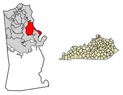 Location in Kenton County, Kentucky | |
| Coordinates: 39°0′47″N 84°29′39″W | |
| Country | United States |
| State | Kentucky |
| County | Kenton |
| Incorporated | 1956[1] |
| Government | |
| • Type | Commission |
| • Mayor | Daniel L. Bell |
| • City Administrator | Brian Haney |
| Area | |
| • Total | 6.21 sq mi (16.07 km2) |
| • Land | 6.11 sq mi (15.83 km2) |
| • Water | 0.09 sq mi (0.24 km2) |
| Elevation | 863 ft (263 m) |
| Population (2010) | |
| • Total | 6,604 |
| • Estimate (2019)[3] | 6,802 |
| • Density | 1,112.71/sq mi (429.64/km2) |
| Time zone | UTC-5 (Eastern (EST)) |
| • Summer (DST) | UTC-4 (EDT) |
| ZIP code | 41015 |
| Area code(s) | 859 |
| FIPS code | 21-75738 |
| GNIS feature ID | 0505030 |
| Website | www |
History
The city was named for a local mill operated during the early 19th century by James Taylor Jr.,[5] the founder of Newport. In 1810 Taylor purchased the land from Jacob Fowler, and the road from what is now Covington to the mill was named Taylor's Mill Road. Others then moved onto the land, felling trees for lumber and clearing land for farming, which began the settling of the city of Taylor Mill.[6]
In 1959 Taylor Mill annexed the former city of Sunny Acres, because its name confused newcomers who associated it with the fictional setting of an episode ("Shady Deal at Sunny Acres") from the popular TV series Maverick. In 1972 the voters of Taylor Mill and Winston Park voted to merge the two cities.
Geography
Taylor Mill is located in northeastern Kenton County at 39°0′47″N 84°29′39″W (39.013062, -84.494192).[7] It is bordered to the north, west, and south by the city of Covington and to the southeast by Fairview and Ryland Heights. An eastern strip of the city runs along the west side of the Licking River, which forms the border of Kenton County. Across the river in Campbell County are the cities of Wilder and Cold Spring.
Interstate 275, the beltway around Cincinnati, passes through the northern part of Taylor Mill, with access from Exit 79 (Kentucky Route 16). KY 16 leads north 5 miles (8 km) to downtown Covington and southwest 14 miles (23 km) to Walton.
According to the United States Census Bureau, Taylor Mill has a total area of 6.3 square miles (16.3 km2), of which 6.1 square miles (15.9 km2) are land and 0.2 square miles (0.4 km2) are water.[4]
Demographics
In 2010 there were 6,604 people and 2,759 housing units in the city, of which 134 were unoccupied.
As of the census[8] of 2000, there were 6,913 people, 2,552 households, and 1,942 families residing in the city. The population density was 1,104.8 people per square mile (426.4/km2). There were 2,604 housing units at an average density of 416.2 per square mile (160.6/km2). The racial makeup of the city was 97.95% White, 0.42% African American, 0.17% Native American, 0.65% Asian, 0.03% Pacific Islander, 0.14% from other races, and 0.64% from two or more races. Hispanic or Latino of any race were 0.78% of the population.
There were 2,552 households, out of which 37.4% had children under the age of 18 living with them, 62.9% were married couples living together, 9.6% had a female householder with no husband present, and 23.9% were non-families. 19.0% of all households were made up of individuals, and 6.9% had someone living alone who was 65 years of age or older. The average household size was 2.71 and the average family size was 3.13.
| Historical population | |||
|---|---|---|---|
| Census | Pop. | %± | |
| 1960 | 710 | — | |
| 1970 | 3,146 | 343.1% | |
| 1980 | 4,509 | 43.3% | |
| 1990 | 5,530 | 22.6% | |
| 2000 | 6,913 | 25.0% | |
| 2010 | 6,604 | −4.5% | |
| 2019 (est.) | 6,802 | [3] | 3.0% |
| U.S. Decennial Census[9] | |||
In the city, the population was spread out, with 26.4% under the age of 18, 9.3% from 18 to 24, 32.3% from 25 to 44, 21.6% from 45 to 64, and 10.4% who were 65 years of age or older. The median age was 36 years. For every 100 females, there were 96.0 males. For every 100 females age 18 and over, there were 93.6 males.
The median income for a household in the city was $54,069, and the median income for a family was $60,000. Males had a median income of $41,430 versus $29,423 for females. The per capita income for the city was $22,906. About 3.1% of families and 4.8% of the population were below the poverty line, including 5.6% of those under age 18 and 5.7% of those age 65 or over.
Business district
The city has established a business district at the junction of I-275 and Taylor Mill Road. This area is termed The Districts of Taylor Mill and contains four development areas. According to the city's website, “The Districts will transform Taylor Mill with high-quality developments comprised of businesses and shops, alongside a synergistic mix of commercial and office buildings, creating a community for everyone to experience and enjoy.[10]
Schools
Taylor Mill Elementary is named after the city and is the school most kids in Taylor Mill attend, although it is technically located in Covington, Kentucky. It enrolls approximately 620 students from preschool to 5th grade.[11]
Woodland Middle School
Scott High School
https://en.wikipedia.org/wiki/Scott_High_School_(Kentucky)
St. Anthony School https://www.saintanthonytaylormill.org/school
References
- Commonwealth of Kentucky. Office of the Secretary of State. Land Office. "Taylor Mill, Kentucky". Accessed 18 February 2014.
- "2019 U.S. Gazetteer Files". United States Census Bureau. Retrieved July 24, 2020.
- "Population and Housing Unit Estimates". United States Census Bureau. May 24, 2020. Retrieved May 27, 2020.
- "Geographic Identifiers: 2010 Demographic Profile Data (G001): Taylor Mill city, Kentucky". American Factfinder. U.S. Census Bureau. Retrieved March 6, 2019.
- Rennick, Robert M. (1988). "Place Names". Kentucky Place Names. Lexington, Kentucky: The University Press of Kentucky. ISBN 0-8131-0179-4. Accessed 13 May 2010.
- Hammons, M., "The History of Taylor Mill", 1988
- "US Gazetteer files: 2010, 2000, and 1990". United States Census Bureau. 2011-02-12. Retrieved 2011-04-23.
- "U.S. Census website". United States Census Bureau. Retrieved 2008-01-31.
- "Census of Population and Housing". Census.gov. Retrieved June 4, 2015.
- "Welcome to the City of Taylor Mill".
- "Taylor Mill Elementary". Retrieved 2019-04-20.
External links
Municipalities and communities of Kenton County, Kentucky, United States | ||
|---|---|---|
| Cities | 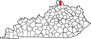 Location of Kenton County, Kentucky | |
| Unincorporated communities | ||
| Footnotes | ‡This populated place also has portions in an adjacent county or counties. | |
| ||
| Authority control |
|---|