Taza
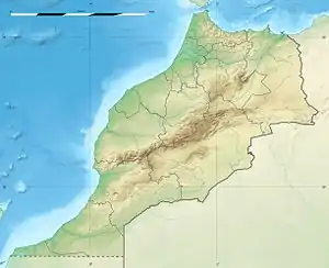
Taza (Berber languages: ⵜⴰⵣⴰ, Arabic: تازة) is a city in northorn Morocco occupying the corridor between the Rif mountains and Middle Atlas mountains, about 120 km east of Fez and 210 km west of Oujda. It recorded a population of 148,406 in the 2019 Moroccan census[2] and is the capital of Taza Province.
Taza
تازة ⵜⴰⵣⴰ | |
|---|---|
    | |
 Taza  Taza | |
| Coordinates: 34°13′N 4°1′W | |
| Country | |
| Region | Fès-Meknès |
| Province | Taza |
| Elevation | 510 m (1,670 ft) |
| Population (2019)[2] | |
| • Total | 148,406 |
| • Rank | 12th in Morocco |
| Time zone | UTC+1.0 (CET) |
History
Historically Taza was known first as 'Ribāt Taza رباط تازة' , a military camp belonging to the Fatimid state, was founded by the local governor Mussa ibn aby Alaâfiya موسى بن أبي العافية who was the leader of Miknassa tribe too.[3] Up to at least the early 20th century, Taza was a considerable trading centre on the route between Fez and the Algerian frontier.[4]
Taza was first settled by Miknasa tribesmen, who gave it its name: Miknasa Taza, similar to Miknasa al-Zeitoun (present-day Meknes, another Miknasa settlement). The Almoravid empire took over Taza in 1074. They were replaced by the Almohad empire in 1132. In 1248 the city was captured by the Marinids. Although Taza barred the route of Turks from Algiers seeking conquest in what is now Morocco,[5] it fell to the French in 1914. The old town has Berber monuments, mosques, and a 14th-century madrasa (Coranic school). Population in 1982 stood at 77,216.
Geography
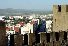
Taza is located in north-central Morocco, in the south of the Rif region right outside the mountain range on a narrow plain. The city is composed of two formerly separate towns built on separate terraces overlooking a mountain valley. The old-Taza town is at an elevation of 1,919 feet (585 m) above sea level and is surrounded by fortifications; the newer town, established by the French in 1920, is located in a fertile plain at an elevation of 1,460 feet (445 m). Fossil remains indicate that caves in the area were inhabited as early as the Paleolithic Period. One of the most important caves in Morocco, Rhar Chara, is close to Taza. This cave is over 7.6 kilometres long.[6]
The city is located in a mountain pass known as the "Taza Gap", where the Rif mountains and the Middle-Atlas range come together. Through this pass successive waves of invaders moved westward onto the Atlantic coastal plains of northwestern Africa.
Climate
Köppen-Geiger climate classification system classifies its climate as hot-summer Mediterranean (Csa).[7] Located along the Atlas Mountains, Taza has a seasonal climate, shifting from cool in winter to hot days in the summer months. Rainfall can reach up to 900 mm per year.
| Climate data for Taza, Morocco (1961-1990) | |||||||||||||
|---|---|---|---|---|---|---|---|---|---|---|---|---|---|
| Month | Jan | Feb | Mar | Apr | May | Jun | Jul | Aug | Sep | Oct | Nov | Dec | Year |
| Average high °C (°F) | 14.4 (57.9) |
16.0 (60.8) |
18.1 (64.6) |
19.9 (67.8) |
24.3 (75.7) |
29.4 (84.9) |
34.9 (94.8) |
34.7 (94.5) |
30.6 (87.1) |
24.2 (75.6) |
18.5 (65.3) |
14.7 (58.5) |
23.3 (73.9) |
| Daily mean °C (°F) | 9.9 (49.8) |
11.3 (52.3) |
13.0 (55.4) |
14.7 (58.5) |
18.4 (65.1) |
22.7 (72.9) |
27.2 (81.0) |
27.3 (81.1) |
24.1 (75.4) |
18.8 (65.8) |
13.8 (56.8) |
10.4 (50.7) |
17.6 (63.7) |
| Average low °C (°F) | 5.4 (41.7) |
6.6 (43.9) |
7.9 (46.2) |
9.6 (49.3) |
12.4 (54.3) |
16.1 (61.0) |
19.6 (67.3) |
19.9 (67.8) |
17.5 (63.5) |
13.4 (56.1) |
9.1 (48.4) |
6.1 (43.0) |
12.0 (53.6) |
| Average precipitation mm (inches) | 109.7 (4.32) |
137.3 (5.41) |
90.4 (3.56) |
94.2 (3.71) |
53.8 (2.12) |
18.6 (0.73) |
8.3 (0.33) |
2.6 (0.10) |
14.0 (0.55) |
48.0 (1.89) |
105.1 (4.14) |
118.7 (4.67) |
800.7 (31.52) |
| Average rainy days | 11.9 | 13.0 | 10.7 | 11.5 | 9.0 | 4.3 | 1.8 | 1.6 | 4.2 | 8.0 | 11.3 | 12.1 | 99.4 |
| Mean monthly sunshine hours | 192.0 | 186.3 | 230.2 | 244.1 | 292.2 | 307.7 | 346.9 | 318.6 | 270.6 | 233.7 | 188.3 | 185.0 | 2,995.6 |
| Source 1: NOAA[8] | |||||||||||||
| Source 2: Climate-Data.org[7] | |||||||||||||
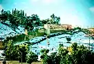
Sights
The old town's main thoroughfare is enlivened by the Grain Market and the Souks where wickerwork, tapestries, jewelry and other goods are sold. The road terminates at a square doubling as a parade ground which sports the Al-Andalous Mosque. The Mosque's minaret, constructed in the 14th century, is wider at the top than at its base.
Bab el-Qebbour Street crosses the Kissaria (covered marketplace), then leads on to the Market Mosque where it meets up with Bab Jamaa gate, the main point of entry of Taza. Somewhat further south, across from Bab el-Rih, the Wind Gate, a bastion dating from the 16th century closes the ring around the kasbah. Taza's city walls, raised in the 12th century and frequently enlarged on later occasions were equipped with a Borj or fortified tower 26 metres (85 ft) wide at the base by the Saadi Ahmed el-Mansour in the 16th century. The gate with an iron grate and the casemates with terraced roofs are clearly influenced by European military architecture of the time.
Topology
The topology of the area has imposed a pattern of urban spread. Viewed from above, the city takes the form of a "T". It has its root in Taza high and stretches north to reach the bed of the Oued Larbaâ. Since the urban stretches east and west along the N6 between Fez and Oujda.
At the dawn of independence, the city consisted of the Medina High Taza, the European district occupying a hill called "No Adrar Illouz. People usually pronounce Draâ louz. This area became the center of town, and finally the station area a few kilometers below.
During the following years (60s, 70s) districts have emerged, midway between downtown and the train station (Bit Goulem, Ourida, Bin-Jradi).
During the 80s, other districts make their appearance, especially north of the city (and Massira Al-Quds), extended and developed areas today. The goal of this extension was the slum clearance. It was a success, since 1986 the city was declared a city without slums. The craze is such that sections like (Massira II) are villa style.
The 90s marked the beginning of the urbanization of the axis center - Taza above. These are buildings with 6 or 7 floors occupying a strategic content between public facilities (municipality, space, civil protection, hospital ibn baja, high school and college ...) and on the other hand, it is down the high rock a hundred yards. This area is also adjacent to the uptown-Qessou meddah, Friouato and Hay Shuhada (developed throughout the last three decades).
More recently this area continues to morph and promises a beautiful view from the heights of the city. The planning now also spread on the road to Fez for several kilometers to reach the intermittently R508 (about Tainast).
The development plan provides a direct link between Taza West (at the "white bridge") and Taza high.
Notable people
- Achraf Bencharki – Moroccan footballer
See also
- Medina of Taza
- Great Mosque of Taza
- Bou Hamara - early 20th century pretender to the throne of Morocco, based in Taza
Notes
- "Climatological Information for Taza, Morocco", Hong Kong Observatory, 2003, web: HKO-Taza.
- "POPULATION LÉGALE DES RÉGIONS, PROVINCES, PRÉFECTURES, MUNICIPALITÉS, ARRONDISSEMENTS ET COMMUNES DU ROYAUME D'APRÈS LES RÉSULTATS DU RGPH 2014" (in Arabic and French). High Commission for Planning, Morocco. 8 April 2015. Retrieved 29 September 2017.
- History of the Arabs and the Berbers and Their Powerful Contemporaries by Ibn khaldūd تاريخ ابن خلدون.
- Meakin, James; Meakin, Kate (1911). . In Chisholm, Hugh (ed.). Encyclopædia Britannica. 18 (11th ed.). Cambridge University Press. p. 854.
- "Taza | Morocco". Encyclopedia Britannica. Retrieved 2017-05-05.
- Gunn, ed. by John (2003). Encyclopedia of caves and karst science. New York [u.a.]: Dearborn. p. 26. ISBN 1579583997.CS1 maint: extra text: authors list (link)
- "Climate: Taza تازة - Climate graph, Temperature graph, Climate table". Climate-Data.org. Retrieved 28 August 2013.
- "Taza Climate Normals 1961–1990". National Oceanic and Atmospheric Administration. Retrieved March 16, 2015.
External links
| Wikivoyage has a travel guide for Taza. |
- Taza online in French
- Parc national de Tazekka in French
Capital: Fes | ||
| Provinces and prefectures | 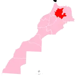 | |
| Cities |
| |